Seoul City Route 21
Seoul Metropolitan City Route 21 (Korean: 서울특별시도 제21호선) is an urban road located in Seoul, South Korea. With a total length of 24.2 km (15.0 mi), this road starts from the Siheung Intersection in Geumcheon District, Seoul to Yeonsinnae Station in Eunpyeong District. This route is a part of Asian Highway 1.
| |
|---|---|
| 서울특별시도 제21호선 | |
| Route information | |
| Length | 24.2 km (15.0 mi) |
| Major junctions | |
| From | Geumcheon District, Seoul |
| To | Eunpyeong District, Seoul |
| Highway system | |
| Asian Highway Network | |
Stopovers

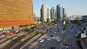
Hangang-daero (on the right corner, you can see Seoul Station entrance.
List of Facilities
IS: Intersection, IC: Interchange
21
| Road name | Name [1] | Hangul name | Connection | Location | Note | |
|---|---|---|---|---|---|---|
| Directly connected with National Route 1 (Gyeongsu-daero) | ||||||
| Siheung-daero | Siheung IS | 시흥사거리 | Seoul | Geumcheon District | ||
| Geumcheon District Office Entrance IS | 금천구청입구 교차로 | Siheung-daero 73-gil | ||||
| Malmi IS | 말미사거리 | Beoman-ro | ||||
| Geumcheon Post Office IS | 금천우체국 교차로 | Dusan-ro Siheung-daero 122-gil |
||||
| Doksan IS | 독산사거리 | Gasan-ro | ||||
| Siheung IC | 시흥 나들목 | Seoul City Route 92 (Nambu Beltway) | ||||
| West: Guro District East: Gwanak District | ||||||
| Digital Complex Entrance IS | 디지털단지입구 교차로 | Digital-ro 32-gil | ||||
| Guro Digital Complex Station IS (Guro Bridge) |
구로디지털단지역 교차로 (구로교) |
Dorimcheon-ro Sinsa-ro |
||||
| West: Yeongdeungpo District East: Dongjak District | ||||||
| Daerim IS | 대림사거리 | Daerim-ro | ||||
| Daerim IS | 대림삼거리 | Singil-ro | ||||
| Yeouidaebang-ro | ||||||
| Boramae Park Entrance IS (Korea Meteorological Administration) |
보라매공원입구 교차로 (기상청) |
Yeouidaebang-ro 20-gil | ||||
| Daebangcheon IS | 대방천사거리 | Daebangcheon-ro | ||||
| Boramae Station IS | 보라매역 교차로 | Seoul City Route 90 (Sinpung-ro, Sangdo-ro) | ||||
| Navy Hall IS | 해군해관앞 교차로 | Gamasan-ro Yeouidaebang-ro 36-gil |
||||
| Sungnam High School Entrance IS (Seoul Regional Military Manpower Administration) |
성남고교입구 교차로 (서울지방병무청) |
Yeouidaebang-ro 43-gil | ||||
| Daelim Apartment IS | 대림아파트 교차로 | Yeouidaebang-ro 44-gil Yeouidaebang-ro 47-gil |
||||
| Daebang Station IS | 대방역 교차로 | Yeongdeungpo-ro Yeouidaebang-ro |
||||
| Noryangjin-ro | Dongjak District | |||||
| Dongjak Telephone Office Entrance IS | 동작전화국입구 교차로 | Deungyong-ro | ||||
| Yuhan | 유한양행 | |||||
| Noryangjin IS (Noryangjin Station) |
노량진삼거리 (노량진역) |
Jangseungbaegi-ro | ||||
| No name | (이름 없음) | Manyang-ro | ||||
| Susan Market Entrance IS | 수산시장입구 교차로 | Noryangjin-ro 17-gil | ||||
| Noryangjin Drainage IS | 노량진배수지 교차로 | Maebong-ro Noryangjin-ro 23-gil |
||||
| Nodeul Station | 노들역 | Yangnyeong-ro | ||||
| Yangnyeong-ro | ||||||
| Hangang Br. IS | 한강대교남단 교차로 | Nodeul-ro Hyeonchung-ro |
||||
| Hangang Bridge | 한강대교 | |||||
| Yongsan District | ||||||
| Hangang Br. IS | 한강대교북단 교차로 | Ichon-ro Local Route 23 (Gangbyeonbuk-ro) Seoul City Route 70 (Gangbyeonbuk-ro) |
||||
| Hangang-daero | ||||||
| Yongsan Station IS | 용산역앞 교차로 | Seobinggo-ro Hangang-daero 21-gil |
||||
| Yongsan Electronics Market Entrance IS (Sinyongsan Station) |
전자상가입구 교차로 (신용산역) |
Saechang-ro | ||||
| Yongsan Post Office IS | 용산우체국 교차로 | Hangang-daero 38-gil | ||||
| Samgakji Station IS | 삼각지역 교차로 | Baekbeom-ro Itaewon-ro |
||||
| War Memorial of Korea | 전쟁기념관 | |||||
| Namyeong IS | 남영삼거리 | Hangang-daero 77-gil Wonhyo-ro |
||||
| Sookmyung Women's University Station IS | 숙대입구역 교차로 | Duteopbawi-ro Cheongpa-ro 47-gil |
||||
| Cheongpa-dong Entrance IS | 청파동입구 교차로 | Cheongpa-ro | ||||
| Seoul Station IS | 서울역 교차로 | Sejong-daero Toegye-ro Huam-ro |
||||
| Tongil-ro | Jung District | |||||
| Yeomcheon Bridge IS (Uiju-ro Underpass) |
염천교 교차로 (의주로지하차도) |
Chilpae-ro | ||||
| National Police Agency IS | 경찰청앞 교차로 | Seoul City Route 60 (Seosomun-ro) | ||||
| National Police Agency | 경찰청 | |||||
| Seodaemun Station IS | 서대문역 교차로 | |||||
| Seodaemun District | ||||||
| Dongnimmun Station IS (Independence Gate) |
독립문역 교차로 (독립문) |
Seoul City Route 50 (Sajik-ro) (Seongsan-ro) |
||||
| Dongnimmun Station | 독립문역 | |||||
| Seodaemun Independence Park IS | 독립공원 교차로 | Tongil-ro 18-gil | ||||
| Muakjae Station | 무악재역 | Tongil-ro 25-gil | ||||
| Inwang Apartment IS | 인왕아파트 교차로 | Tongil-ro 34-gil | ||||
| Hongje IS | 홍제삼거리 | Moraenae-ro | ||||
| Hongje Station | 홍제역 | |||||
| Hongeun IS | 홍은사거리 | Yeonhui-ro Segeomjeong-ro |
||||
| Nokbeon Station IS | 녹번역 교차로 | Eunpyeong-ro | Eunpyeong District | |||
| (Former Korea Centers for Disease Control and Prevention Headquarter) | (구 질병관리본부) | Seoul City Route 20 (Jinheung-ro) |
||||
| Bulgwang Station IS | 불광역 교차로 | Bulgwang-ro | ||||
| Dongmyung Girls' High School IS | 동명여고 교차로 | Yeongmal-ro | ||||
| Yeonsinnae Station IS | 연신내역 교차로 | |||||
| Connected with National Route 1 (Tongil-ro) | ||||||
References
- Intersection and interchange are also included , as well as buildings and facilities in the surrounding area
This article is issued from Wikipedia. The text is licensed under Creative Commons - Attribution - Sharealike. Additional terms may apply for the media files.
