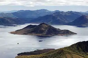
Scotts Peak
Scotts Peak is a mountain in South West Tasmania which is associated with the construction and flooding of the original Lake Pedder, as the lake now completely surrounds the peak.[1] It lies east of the Frankland Range.
Scotts Peak
There is a Scotts Peak Dam and a Scotts Peak Dam Road in the region.[2]
Scotts Peak is accessible by Scotts Peak Dam Road and the Lake Pedder boat ramp. Many people kayak across the reservoir to hike Scotts Peak. [3]
Further reading
- (1990) Draft recreation development plan : Strathgordon - Scotts Peak area. Hobart, Tas. : Department of Parks, Wildlife and Heritage.
References
- Burgess, Georgie (5 October 2019). "Why do environmentalists want to drain Tasmania's Lake Pedder?". ABC News. Retrieved 5 April 2020.
- "Hydro Tasmania" (PDF). September 2014.
- "Scotts Peak Dam Road". www.roamingdownunder.com. Retrieved 31 March 2020.
- Digital, Ionata. "Lake Pedder - Scotts Peak". MAST. Retrieved 5 April 2020.
- "Search for missing bushwalkers at Scotts Peak". Tasmania Police. Retrieved 5 April 2020.
This article is issued from Wikipedia. The text is licensed under Creative Commons - Attribution - Sharealike. Additional terms may apply for the media files.