Saloma, Kentucky
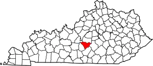
Saloma is an unincorporated community in Taylor County, Kentucky, United States. It lies along Routes 527 and 744 northwest of the city of Campbellsville, the county seat of Taylor County.[1] Its elevation is 906 feet (276 m).[2]
Saloma | |
|---|---|
 Saloma Baptist Church | |
 Saloma Location within the state of Kentucky  Saloma Saloma (the United States) | |
| Coordinates: 37°24′43″N 85°23′34″W | |
| Country | United States |
| State | Kentucky |
| County | Taylor |
| Elevation | 906 ft (276 m) |
| Time zone | UTC-5 (Eastern (EST)) |
| • Summer (DST) | UTC-4 (EDT) |
| GNIS feature ID | 502817 |
Saloma was established in 1838, and had its own post office during the 19th century. The origin of the name "Saloma" is unknown.[3]
References
- Rand McNally. The Road Atlas '06. Chicago: Rand McNally, 2006, p. 42.
- U.S. Geological Survey Geographic Names Information System: Saloma, Kentucky, Geographic Names Information System, 1979-09-20. Accessed 2007-12-31.
- Rennick, Robert M. (1987). Kentucky Place Names. University Press of Kentucky. p. 262. ISBN 0813126312. Retrieved 2017-07-17.
This article is issued from Wikipedia. The text is licensed under Creative Commons - Attribution - Sharealike. Additional terms may apply for the media files.
