Saint-Crépin, Charente-Maritime
Saint-Crépin is a commune in the Charente-Maritime department in the Nouvelle-Aquitaine region in southwestern France.
Saint-Crépin | |
|---|---|
.JPG.webp) The town hall in Saint-Crépin | |
Location of Saint-Crépin 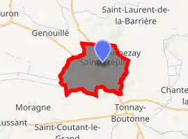
| |
 Saint-Crépin  Saint-Crépin | |
| Coordinates: 46°00′14″N 0°43′55″W | |
| Country | France |
| Region | Nouvelle-Aquitaine |
| Department | Charente-Maritime |
| Arrondissement | Rochefort |
| Canton | Saint-Jean-d'Angély |
| Government | |
| • Mayor (2020–2026) | Matthieu Cadot |
| Area 1 | 13.94 km2 (5.38 sq mi) |
| Population (2017-01-01)[1] | 347 |
| • Density | 25/km2 (64/sq mi) |
| Time zone | UTC+01:00 (CET) |
| • Summer (DST) | UTC+02:00 (CEST) |
| INSEE/Postal code | 17321 /17380 |
| Elevation | 1–65 m (3.3–213.3 ft) (avg. 40 m or 130 ft) |
| 1 French Land Register data, which excludes lakes, ponds, glaciers > 1 km2 (0.386 sq mi or 247 acres) and river estuaries. | |
Population
| Year | Pop. | ±% |
|---|---|---|
| 1962 | 216 | — |
| 1968 | 247 | +14.4% |
| 1975 | 235 | −4.9% |
| 1982 | 226 | −3.8% |
| 1990 | 237 | +4.9% |
| 1999 | 217 | −8.4% |
| 2008 | 252 | +16.1% |
References
- "Populations légales 2017". INSEE. Retrieved 6 January 2020.
| Wikimedia Commons has media related to Saint-Crépin (Charente-Maritime). |
| Authority control |
|---|
This article is issued from Wikipedia. The text is licensed under Creative Commons - Attribution - Sharealike. Additional terms may apply for the media files.