Rong Mueang
Rong Mueang (Thai: รองเมือง, pronounced [rɔ̄ːŋ mɯ̄a̯ŋ]) is a khwaeng (subdistrict) of Pathum Wan district, downtown Bangkok.
Rong Mueang
รองเมือง | |
|---|---|
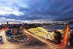
 Aerial view of Hua Lamphong railway station in evening, the road on the right and parallel to the station is Rong Mueang road. | |
| Country | |
| Province | Bangkok |
| Khet | Pathum Wan |
| Population (2018) | |
| • Total | 17,181 |
| • Density | 13,205.99/km2 (34,203.4/sq mi) |
| Time zone | UTC+7 (ICT) |
| Postal code | 10330 |
| TIS 1099 | 100701 |
History
Its name after Rong Mueang road, a short route that runs through the area. The road runs parallel to the Hua Lamphong railway station side as far as ending at Rama I road on the Kasat Suek bridge, with a distance of about 900 m. (2,952 ft.).
This road named in honour of Phraya Indra Dhibodee Siharat Rong Mueang (M.R. Lop Suthat), a nobleman during the King Rama V's reign. He was one of the nobles of those days who helped build manay roads in Bang Rak district for real estate investment such as Si Phraya, Decho, Surawong etc. Rong Mueang is regarded as a road in the south of Khlong Phadung Krung Kasem canal. It began construction in the year 1902 until it was completed and there was an official opening ceremony on March 29, 1904.[1]
Geography
Rong Mueang has an area of approximately 1.423 km2 (0.549 mi2), considered as an urban area and an economic center.
Neighbouring subdistricts are (from the north clockwise): Si Yaek Maha Nak in Dusit district, Thanon Phetchaburi in Ratchathewi district, Wang Mai in its district, Maha Phruettharam in Bang Rak district, Pom Prap, Wat Thep Sirin, and Khlong Maha Nak in Pom Prap Sattru Phai district.[2]
The area also consists of at least four communities, for example Trok Salak Hin, Wat Duang Khae, Flat Rot Fai, and Charat Mueang etc. Which in these communities, there are at least seven other interesting landmarks.[3]
Moreover, Rong Mueang is also home to many restaurants,[3] some of them was chosen to be Bib Gourmand from Michelin Guide as well.[4]
Places
Important places

.jpg.webp)

- Hua Lamphong railway station (Bangkok railway station) and State Railway of Thailand (SRT) with Railway Police Division headquarters
- Pathum Wan district office
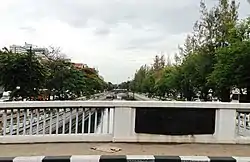
- Kasat Suek bridge (Yotse)
- Nopphawong bridge
- Department of Alternative Energy Development and Efficiency (DEDE) headquarters and Ban Bhibundhamma
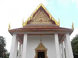
- Wat Boromniwat
- Wat Duang Khae
- Wat Sa Bua
- Wat Chamni Hatthakan (Sam Ngam)
- Wat Chai Mongkol (Chang Saeng)
- Srijulsup Tower (former Election Commission of Thailand (ECT) headquarters)
- Sitabutr Bamrung School
- Bobae market (shares with Khlong Maha Nak subdistrict, Pom Prap Sattru Phai district)
Transportation
Rong Mueang is served by Hua Lamphong MRT station, Bamrung Mueang road, and Khlong Phadung Krung Kasem boat service[2]
- Rama I road
- Banthat Thong road
- Rama IV road
- Liap Khlong Phadung Krung Kasem road
- Rong Mueang road
- Charat Mueang road
- Charu Mueang road
- Charoen Mueang road
- Rama VI road
- Sirat Expressway
References
- Kanthika Sriudom, 2006. “King Chulalongkorn’s Blessings for Modern Bangkok.” Journal of Muang Boran 32, 1 (Jan.-Mar. 2006): 36-49.
- "ข้อมูลแขวงรองเมือง เขตปทุมวัน กรุงเทพมหานคร" [Information of Rong Mueang subdistrict, Pathum Wan district, Bangkok]. ThaiTambon (in Thai).
- pimchanok (2016-02-01). "เช็คอิน "7 รองเมือง" ชมถิ่นวิถีสุข" [Check in "7 Rong Mueang" watch the places of happiness]. Thaihealth (in Thai). Retrieved 2019-09-03.
- Hsiao, Tina (2019-06-06). "Jay Oh: Enjoy Late Night Comfort Food with Good Friends". Michelin Guilde. Retrieved 2019-09-04.