Riffle
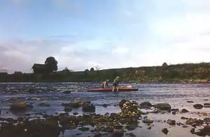
A riffle is a shallow landform in a flowing channel,[1] and it has specific topographic, sedimentary, and hydraulic indicators. These are almost always assessed at a very low discharge compared to the flow that fills the channel[2] (approximately 10–20%), and as a result the water moving over a riffle appears shallow and fast, with a wavy, disturbed water surface. The water's surface over a riffle at low flow also has a much steeper slope than that over other in-channel landforms. Channel sections with a mean water surface slope of roughly 0.1 to 0.5% exhibit riffles, though they can occur in steeper or gentler sloping channels with coarser or finer bed materials, respectively. Except in the period after a flood (when fresh material is deposited on a riffle), the sediment on the riverbed in a riffle is usually much coarser than on that in any other in-channel landform.

Terrestrial valleys normally consist of channels – geometric depressions in the valley floor carved by flowing water – and overbank regions that include floodplains and terraces. Some channels have shapes and sizes that hardly change along the river; these do not have riffles. However, many channels exhibit readily apparent changes in width, bed elevation, and slope. In these cases, scientists realized that the riverbed often tends to rise and fall with distance downstream relative to an average elevation of the river's slope. That led scientists to map the bed elevation down the deepest path in a channel, called the thalweg, to obtain a longitudinal profile. Then, the piecewise linear slope of the river is computed and removed to leave just the rise and fall of the elevation about the channel's trendline. According to the zero-crossing method,[3][4] riffles are all the locations along the channel whose residual elevation is greater than zero. Because of the prevalence of this method for identifying and mapping riffles, riffles are often thought of as part of a paired sequence, alternating with pools- the lows between the riffles. However, modern topographic maps of rivers with meter-scale resolution reveal that rivers exhibit a diversity of in-channel landforms.[5]
For a long time, scientists have observed that, all other things being equal, riffles tend to be substantially wider than other in-channel landforms,[6] but only recently has there been high enough quality of river maps to confirm that this is true.[7] The physics mechanism that explains why this happens is called flow convergence routing.[8][9] This mechanism may be used in river engineering to design self-sustainable riffles,[10][11] given a suitable sediment supply and flow regime. When an in-channel landform is shallow and narrow, instead of shallow and wide, it is called a nozzle.
Riffles are biologically very important, because many aquatic species rely on them in one way or another. Many benthic macroinvertebrates are present in riffles, so fish often locate just downstream of a riffle to wait for these small creatures to drift down to them. That draws fisherman to these natural fish feeding stations as well. Riffles also serve to aerate the water, increasing the amount of dissolved oxygen.[12]
Macroinvertebrates in riffles
Litter patches are a collection of leaves, coarse particulate organic matter, and small woody stems that can be found throughout riffles.[13] In riffles, these patches form at a velocity between 13 and 89 cm s^-1, which allows for certain types of litter to be more abundant in riffles because they can stand up to the flow.[13] Leaf litter is most commonly found in riffles, and thus influenced the type of macroinvertebrate functional group is found in riffles, like stoneflies being the dominant shredder species found in riffles.[13] Other macroinvertebrates found in riffles are mayflies (Ephemeroptera), but not flies (Diptera).[14] Midges (Chironomidae) and aquatic worms are also located in riffles.[15]
Riffles also create a safe habitat for macroinvertebrates because of the varying depth, velocity, and substrate type found in the riffle.[16] Densities of macroinvertebrates vary riffle to riffle because of seasonality or the habitat surrounding the riffle, but macroinvertebrate makeup is fairly consistent.[16] While it can only be assumed that riffles can host a higher level of densities because of higher dissolved oxygen levels, there is a proven positive association between phosphate levels and macroinvertebrates in riffles, indicating that phosphate is an important nutrient for them.[16] Seasonality is important for macroinvertebrate densities, and is characterized by temperature, like summer and winter, or it can be characterized by wetness, like wet and dry seasons. Macroinvertebrates are found in lower abundance during the rainy or wet season due to the high, constant amount of water into the riffle changing the system’s temperature, water velocity, and the aquatic community structure.[15] Also, food and shelter and low flow rates during the dry season make it a more habitable time for higher densities of macroinvertebrates.[15]
Anthropogenic threats
Riffles provide important habitat and food production for various aquatic organisms, but humans have altered aquatic ecosystems worldwide through infrastructure and land use changes.[17] Human interference of stream or river flow decreases sediment sizes, resulting in less riffles.[18]
Specifically, weirs and other dams have reduced existing riffles by flattening the channel with smaller substrate, resulting in habitat fragmentation.[18][19] Dam removal has increased in recent times and its effects on riffles vary and are complex, but generally, riffles may redevelop.[17] As these riffles develop, however, they often have a lower biodiversity than the pre-dam ecosystem but benefit aquatic biodiversity in the long term.[17] Following weir removal, riffle fish populations have increased in diversity and density, and these fish have moved upstream to inhabit new riffles that redevelop after dam removal.[17][20] The importance of riffles in supporting diverse assemblages of aquatic biota within streams and rivers may contribute to the increasing trend of dam removal.
Human land use change, specifically development of land, can indirectly affect riffles and riffle quality.[21] Terrestrial vegetation, such as tree branches and leaf litter, contribute to the formation of riffles and stabilization of the ecosystem's channel, and as development reduces this vegetation, riffles may be diminished.[22] Species richness and diversity within riffles are susceptible to anthropogenic land use changes, and management options for restoring these riffles to increase aquatic biodiversity include removing sand and sedimentation and enhancing water flow, to offset impacts from land use change.[19]
Aquaria
In the fishkeeping world, a "riffle tank" is one specializing in aquatic life that originates in places with powerful currents like riffles. These are usually emulated with very powerful pumps.[23]

Gold mining
The term is also applied to strips of wood, metal or plastic laid across the washing tables during gravity separation of gold in alluvial or placer mining.
References
- Leopold, Luna; Wolman, M. Gordon (1957). "River channel patterns: Braided, meandering, and straight". Professional Paper 282-B. United States Geological Survey: 50. Cite journal requires
|journal=(help) - Wyrick, J. R.; Senter, A. E.; Pasternack, G. B. (2014-04-01). "Revealing the natural complexity of fluvial morphology through 2D hydrodynamic delineation of river landforms". Geomorphology. 210: 14–22. Bibcode:2014Geomo.210...14W. doi:10.1016/j.geomorph.2013.12.013.
- Milne, J. A. (1982-04-01). "Bed-material size and the riffle-pool sequence". Sedimentology. 29 (2): 267–278. Bibcode:1982Sedim..29..267M. doi:10.1111/j.1365-3091.1982.tb01723.x. ISSN 1365-3091.
- Carling, Paul A.; Orr, Harriet G. (2000-04-01). "Morphology of riffle–pool sequences in the River Severn, England". Earth Surface Processes and Landforms. 25 (4): 369–384. doi:10.1002/(SICI)1096-9837(200004)25:4<353::AID-ESP59>3.0.CO;2-5. ISSN 1096-9837.
- Wyrick, J. R.; Pasternack, G. B. (2014-05-15). "Geospatial organization of fluvial landforms in a gravel–cobble river: Beyond the riffle–pool couplet". Geomorphology. 213: 48–65. Bibcode:2014Geomo.213...48W. doi:10.1016/j.geomorph.2013.12.040.
- Richards, K. S. (1976-06-01). "Channel width and the riffle-pool sequence". GSA Bulletin. 87 (6): 883–890. Bibcode:1976GSAB...87..883R. doi:10.1130/0016-7606(1976)87<883:CWATRS>2.0.CO;2. ISSN 0016-7606.
- Brown, Rocko A.; Pasternack, Gregory B. (2017-01-11). "Bed and width oscillations form coherent patterns in a partially confined, regulated gravel–cobble-bedded river adjusting to anthropogenic disturbances". Earth Surface Dynamics. 5 (1): 1–20. Bibcode:2017ESuD....5....1B. doi:10.5194/esurf-5-1-2017. ISSN 2196-6311.
- MacWilliams, Michael L.; Wheaton, Joseph M.; Pasternack, Gregory B.; Street, Robert L.; Kitanidis, Peter K. (2006-10-01). "Flow convergence routing hypothesis for pool-riffle maintenance in alluvial rivers" (PDF). Water Resources Research. 42 (10): W10427. Bibcode:2006WRR....4210427M. doi:10.1029/2005WR004391. ISSN 1944-7973.
- Sawyer, April M.; Pasternack, Gregory B.; Moir, Hamish J.; Fulton, Aaron A. (2010-01-15). "Riffle-pool maintenance and flow convergence routing observed on a large gravel-bed river". Geomorphology. 114 (3): 143–160. Bibcode:2010Geomo.114..143S. doi:10.1016/j.geomorph.2009.06.021.
- Wheaton, Joseph M.; Brasington, James; Darby, Stephen E.; Merz, Joseph; Pasternack, Gregory B.; Sear, David; Vericat, Damiá (2010-05-01). "Linking geomorphic changes to salmonid habitat at a scale relevant to fish". River Research and Applications. 26 (4): 469–486. doi:10.1002/rra.1305. ISSN 1535-1467.
- Brown, Rocko A.; Pasternack, Gregory B.; Lin, Tin (2016-04-01). "The Topographic Design of River Channels for Form-Process Linkages". Environmental Management. 57 (4): 929–942. Bibcode:2016EnMan..57..929B. doi:10.1007/s00267-015-0648-0. ISSN 0364-152X. PMID 26707499. S2CID 206946036.
- Gary Chapman (1986). Ambient Aquatic Life Water Quality Criteria for Dissolved Oxygen. U.S. Environmental Protection Agency, Office of Water Regulations and Standards. p. 3.
- Kobayashi, S.; Kagaya, T. (2002-04-01). "Differences in litter characteristics and macroinvertebrate assemblages between litter patches in pools and riffles in a headwater stream". Limnology. 3 (1): 37–42. doi:10.1007/s102010200004. ISSN 1439-8621. S2CID 23951148.
- Logan, P.; Brooker, M. P. (1983-01-01). "The macroinvertebrate faunas of riffles and pools". Water Research. 17 (3): 263–270. doi:10.1016/0043-1354(83)90179-3. ISSN 0043-1354.
- Righi-Cavallaro, Karina Ocampo; Roche, Kennedy Francis; Froehlich, Otávio; Cavallaro, Marcel Rodrigo (September 2010). "Structure of macroinvertebrate communities in riffles of a Neotropical karst stream in the wet and dry seasons". Acta Limnologica Brasiliensia. 22 (3): 306–316. doi:10.4322/actalb.02203007. ISSN 2179-975X.
- Cook, Danielle R.; Sullivan, S. Mažeika P. (2018). "Associations between riffle development and aquatic biota following lowhead dam removal". Environmental Monitoring and Assessment. 190 (6): 339. doi:10.1007/s10661-018-6716-1. ISSN 0167-6369. PMC 5945803. PMID 29748723.
- Cook, Danielle R.; Sullivan, S. Mažeika P. (2018). "Associations between riffle development and aquatic biota following lowhead dam removal". Environmental Monitoring and Assessment. 190 (6): 339. doi:10.1007/s10661-018-6716-1. ISSN 0167-6369. PMC 5945803. PMID 29748723.
- Salant, Nira L.; Schmidt, John C.; Budy, Phaedra; Wilcock, Peter R. (2012). "Unintended consequences of restoration: Loss of riffles and gravel substrates following weir installation". Journal of Environmental Management. 109: 154–163. doi:10.1016/j.jenvman.2012.05.013. ISSN 0301-4797. PMID 22728828.
- Faulks, Leanne K.; Gilligan, Dean M.; Beheregaray, Luciano B. (2011). "The role of anthropogenic vs. natural in-stream structures in determining connectivity and genetic diversity in an endangered freshwater fish, Macquarie perch (Macquaria australasica): Anthropogenic vs. natural in-stream structures in M. australasica". Evolutionary Applications. 4 (4): 589–601. doi:10.1111/j.1752-4571.2011.00183.x. PMC 3352423. PMID 25568007.
- Bushaw-Newton, Karen L.; Hart, David D.; Pizzuto, James E.; Thomson, James R.; Egan, Jennifer; Ashley, Jeffrey T.; Johnson, Thomas E.; Horwitz, Richard J.; Keeley, Melissa; Lawrence, Joy; Charles, Don (2002). "An Integrative Approach Towards Understanding Ecological Responses to Dam Removal: The Manatawny Creek Study". Journal of the American Water Resources Association. 38 (6): 1581–1599. Bibcode:2002JAWRA..38.1581B. doi:10.1111/j.1752-1688.2002.tb04366.x. ISSN 1093-474X.
- MALONEY, KELLY O.; WELLER, DONALD E. (2010). "Anthropogenic disturbance and streams: land use and land-use change affect stream ecosystems via multiple pathways". Freshwater Biology. 56 (3): 611–626. doi:10.1111/j.1365-2427.2010.02522.x. ISSN 0046-5070.
- Amaral, P. H. M. d.; Silveira, L. S. d.; Rosa, B. F. J. V.; Oliveira, V. C. d.; Alves, R. d. G. (2015). "Influence of Habitat and Land Use on the Assemblages of Ephemeroptera, Plecoptera, and Trichoptera in Neotropical Streams". Journal of Insect Science. 15 (1): 60. doi:10.1093/jisesa/iev042. ISSN 1536-2442. PMC 4535583. PMID 25989807.
- Setting up a Riffle Tank, by Cliff Zoller