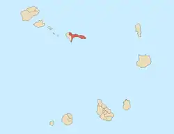
Ribeira Brava, Cape Verde (municipality)
Ribeira Brava is a concelho (municipality) of Cape Verde. Situated in the eastern part of the island of São Nicolau, it covers 65% of the island area (224.8 km2), and is home to 59% of its population (7,580 at the 2010 census).[2] Its seat is the city Ribeira Brava.
Ribeira Brava | |
|---|---|
Municipality | |
 Main square in Ribeira Brava | |
 Seal | |
 | |
| Coordinates: 16.62°N 24.23°W | |
| Country | Cape Verde |
| Island | São Nicolau |
| Seat | Ribeira Brava |
| Area | |
| • Total | 224.8 km2 (86.8 sq mi) |
| Population (2010)[1] | |
| • Total | 7,580 |
| • Density | 34/km2 (87/sq mi) |
| ID | 31 |
| Website | http://www.cmrb.cv/ |
Subdivisions
The municipality consists of two freguesias (civil parishes):
History
The municipality was created in 2005, when the older municipality of São Nicolau was split in two, the southwestern part becoming the Municipality of Tarrafal de São Nicolau and the northeastern part becoming the Municipality of Ribeira Brava.[3]
Demography
| Year | Population |
|---|---|
| 1980[4] | 11,465 |
| 1990[4] | 11,556 |
| 2000[4] | 11,794 |
| 2010[2] | 7,580 |
Politics
Since 2016, the local party GIRB is the ruling party of the municipality. The results of the latest elections, in 2016:[5]
| Party | Municipal Council | Municipal Assembly | ||
|---|---|---|---|---|
| Votes% | Seats | Votes% | Seats | |
| GIRB | 32.70 | 2 | 31.67 | 4 |
| MpD | 32.50 | 2 | 33.32 | 5 |
| PAICV | 29.95 | 1 | 30.11 | 4 |
Persons
- Amílcar Spencer Lopes (b. 1948), president of the National Assembly between 1991 and 1996
- João Lopes Filho (b. 1950), anthropologist and linguist
References
- "2010 Census results". Instituto Nacional de Estatística Cabo Verde (in Portuguese). 24 November 2016.
- 2010 Census Summary
- Lei nº 67/VI/2005, p. 61
- Ribeira Brava, opendataforafrica.org
- Official results local elections 2016, Boletim Oficial I Série, Número 53, 23 September 2016
External links
- Official website of the municipality (in Portuguese)
This article is issued from Wikipedia. The text is licensed under Creative Commons - Attribution - Sharealike. Additional terms may apply for the media files.
