Raposos
Raposos is a Brazilian municipality located in the state of Minas Gerais. The city belongs to the mesoregion Metropolitana de Belo Horizonte and to the microregion of Belo Horizonte.
Raposos | |
|---|---|
Municipality | |
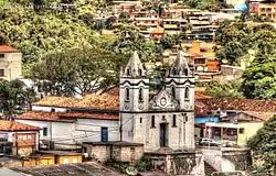
 Igreja de Nossa Senhora da Conceição | |
 Flag  Seal | |
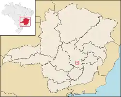
 Location of Raposos within Minas Gerais | |
| Coordinates: 19°58′01″S 43°48′14″W | |
| Country | Brazil |
| State | Minas Gerais |
| Population (2020 [1]) | |
| • Total | 16,429 |
Geography
The municipality contains the Raposos gold mines opened by the Saint John d'El Rey Mining Company around 1910. As of 1955 the main lodes were the Espiritu Santo, Mina Grande and Espiritu West, which were connected by underground workings and had reached a depth of about 640 metres (2,100 ft).[2] At the end of 1955 the Raposos mines had total reserves of 1,694,080 metric tons of ore with an average of 9.5 grams of gold per ton.[3]
The municipality contains about 10% of the 31,270 hectares (77,300 acres) Serra do Gandarela National Park, created in 2014.[4]
References
- IBGE 2020
- Jacob E. Gair 1949, p. A-59.
- Jacob E. Gair 1949, p. A-60.
- PARNA de Serra do Gandarela – ISA.
| Wikimedia Commons has media related to Raposos. |
Sources
- Jacob E. Gair (1949), "Geology and ore deposits of the Nova Lima and Rio Acima quadrangles, Minas Gerais, Brazil", Geological Survey Professional Paper, U.S. Government Printing Office, retrieved 2016-08-12
- PARNA de Serra do Gandarela (in Portuguese), ISA: Instituto Socioambiental, retrieved 2016-06-12
Capital: Belo Horizonte | |||||||||||||||||||||||||
|  | ||||||||||||||||||||||||
|
| |||||||||||||||||||||||||
| |||||||||||||||||||||||||
| |||||||||||||||||||||||||
| |||||||||||||||||||||||||
| |||||||||||||||||||||||||
| |||||||||||||||||||||||||
| |||||||||||||||||||||||||
| |||||||||||||||||||||||||
| |||||||||||||||||||||||||
| |||||||||||||||||||||||||
This article is issued from Wikipedia. The text is licensed under Creative Commons - Attribution - Sharealike. Additional terms may apply for the media files.