Parry Channel
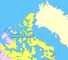
The Parry Channel is a natural waterway through the central Canadian Arctic Archipelago. Its eastern two-thirds lies in the territory of Nunavut, while its western third (west of 110° West) lies in the Northwest Territories. It runs east to west, connecting Baffin Bay in the east with the Beaufort Sea in the west. Its eastern end is the only practical entrance to the Northwest Passage. Its western end would be a natural exit from the archipelago were it not filled with ice. The channel separates the Queen Elizabeth Islands to the north from the rest of Nunavut.[1]

Named parts of the Channel are, from east to west, Lancaster Sound, Barrow Strait, Viscount Melville Sound and McClure Strait. On the south are Baffin Island, Admiralty Inlet (Nunavut) and the Brodeur Peninsula of Baffin Island, Prince Regent Inlet which leads to the large Gulf of Boothia, Somerset Island (Nunavut), Peel Sound which is the main route south, Prince of Wales Island (Nunavut), the ice-choked M'Clintock Channel, Victoria Island (Canada), the narrow Prince of Wales Strait and Banks Island. On the north are Devon Island, Wellington Channel, Cornwallis Island (Nunavut), McDougall Sound, Bathurst Island (Nunavut), Melville Island (Arctic) and Prince Patrick Island.
Parry Channel is named after Arctic explorer William Edward Parry who in 1819 got as far as Melville Island before being blocked by ice at McClure Strait. The next ship to get this far west was part of the Edward Belcher expedition in 1850.
References
- "Nunavut: Our newest territory". thecanadapage.org. Archived from the original on 2008-05-13. Retrieved 2008-06-02.