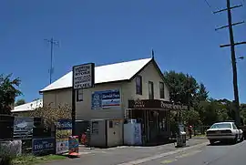
Panmure, Victoria
Panmure /pənˈmjuːə/ is a small town in the south west of Victoria, Australia. At the 2006 census, Panmure and the surrounding area had a population of 421.[1] Situated on the Princes Highway, the town is half way between Terang and Warrnambool.
| Panmure Victoria | |
|---|---|
 General store and post office | |
 Panmure | |
| Coordinates | 38°20′0″S 142°44′0″E |
| Population | 424 (2016 census)[1] |
| Postcode(s) | 3265 |
| Location |
|
| LGA(s) | Shire of Moyne |
| State electorate(s) | South-West Coast |
| Federal Division(s) | Wannon |
The township was established in the 1850s. Timbercutters came to the area to harvest the River Red gum, stringybark and messmate trees, which were transported by bullock teams to nearby sawmills. The clearing of the native forest and relatively high rainfall gave rise to a thriving dairy industry, which persists today. Panmure Post Office opened on 1 January 1867.[2]
At its peak in the late nineteenth Century, Panmure consisted of a police station and courthouse, two sawmills, a blacksmith, a butcher, three churches, a pub, two stores, a bakery, and a school. The railway though the town was opened in 1890,[3] and the town once had its own local railway station.
The town hit international headlines, in 1883, when a ten-year-old girl, Margaret Nolan, was brutally murdered and sexually assaulted by a man called Henry Morgan. Margaret Nolan was the eldest daughter of local grazier John Nolan, and his wife Bridget (née Curtis). The girl's body was found by her father, at the intersection of the Ellerslie-Panmure Road and the Princes highway. [4] Morgan was executed for the crime in 1884, at Ararat.[5]
On 16 February 1983, the "Ash Wednesday" bushfires swept through the district destroying many homes, farm buildings and livestock. Today, the town has a pub, a general store/post office, a primary school and sporting facilities that host cricket, netball clubs and an Australian Rules football team competing in the Warrnambool & District Football League.
The Mount Emu Creek runs through the town, and forms a nice swimming hole known as the "hole" or the "big hole". Adjacent to the swimming hole in the Recreation Reserve is a natural spring that is of cultural significance to the local Indigenous community.
Mount Warrnambool, a prominent landmark, is nearby.
Traditional ownership
The formally recognised traditional owners for the area in which Panmure sits are the Eastern Maar people,[6] who are represented by the Eastern Maar Aboriginal Corporation.[7]
References
| Wikimedia Commons has media related to Panmure, Victoria. |
- Australian Bureau of Statistics (25 October 2007). "Panmure (State Suburb)". 2006 Census QuickStats. Retrieved 27 June 2010.
- Premier Postal History. "Post Office List". Retrieved 11 April 2008.
- Sid Brown (March 1990). "Tracks Across the State". Newsrail. Australian Railway Historical Society (Victorian Division). pp. 71–76.
- https://trove.nla.gov.au/newspaper/article/6049105?searchTerm=margaret%20nolan%20panmure
- https://trove.nla.gov.au/newspaper/article/237136470?searchTerm=panmure%20murderer
- "Map of formally recognised traditional owners". Aboriginal Victoria. Retrieved 2 June 2020.
- "Eastern Maar Aboriginal Corporation". Eastern Maar Aboriginal Corporation. Retrieved 2 June 2020.