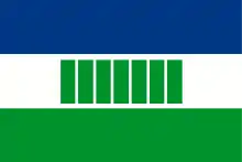
Ovamboland
Ovamboland (also: Owamboland) was a Bantustan in South West Africa (present-day Namibia), intended by the apartheid government to be a self-governing homeland for the Ovambo people.
Ovamboland | |||||||||
|---|---|---|---|---|---|---|---|---|---|
| 1968–1989 | |||||||||
 Flag | |||||||||
 Map of the bantustan. | |||||||||
| Status | Bantustan | ||||||||
| Capital | Ondangua | ||||||||
| History | |||||||||
| 1968 | |||||||||
• Re-integrated into Namibia | May 1989 | ||||||||
| Currency | South African rand | ||||||||
| |||||||||

The term originally referred to the parts of northern Namibia inhabited by the Ovambo ethnic group, namely the area controlled by the traditional Ovambo kingdoms in pre-colonial and early colonial times, such as Ondonga, Ongandjera, and Oukwanyama.[1] Its endonym is Ovambo ~ Owambo.
Background
In the 1960s South Africa, which was administering South West Africa under a League of Nations mandate, came under increased international pressure regarding its minority White rule over the majority of Blacks. The solution envisaged by South Africa—the Odendaal Plan—was to separate the white and the non-white population, grant self-government to the isolated black territories, and thus make Whites the majority population in the vast remainder of the country. Moreover it was envisaged that by separating each ethnic group and confining people by law to their restricted areas, discrimination by race would automatically disappear.[2]
The demarcated territories were called the bantustans, and the remainder of the land was called the Police Zone. Forthwith, all non-white people employed in the Police Zone became migrant workers, and pass laws were established to police movement in and out of the bantustans.[2]
The combined territory of all bantustans was roughly equal in size to the Police Zone. However, all bantustans were predominantly rural and excluded major towns. All harbours, most of the railway network and the tarred road infrastructure, all larger airports, the profitable diamond areas and the national parks were situated in the Police Zone.[2] An exception to this was Rehoboth, the bantustan status of which was similar to the autonomy it had enjoyed under German rule.
Establishment
Ovamboland, set up in 1968, was the first fully functional Bantustan in South West Africa. As the Ovambo people already resided here, resettlement was not necessary. Furthermore, the area already had an existing structure of governance in the form of traditional authorities. The population was, however, split into those who farmed near their homes, and those who worked in mines, factories, on farms and in households outside the Bantustan.[3] Self-government was granted in 1973.
Ovamboland was the setting of a protracted insurgency waged by the People's Liberation Army of Namibia (PLAN) during the South African Border War.[4]
Since independence of Namibia
Owambo, like other homelands in South West Africa, was abolished in May 1989 at the start of the transition to independence. The region is now commonly referred to as The North but the term Ovamboland is still in use. More than half of the entire population lives here on just 6% of the Namibian territory.
References
- Hayes, Patricia (2000). Hall, Catherine (ed.). Cultures of Empire: A Reader: Colonizers in Britain and the Empire in the Nineteenth and Twentieth Centuries. New York: Routledge Books. pp. 329–330. ISBN 978-0415929073.
- D'Amato, Anthony A (October 1966). "The Bantustan Proposals for South-West Africa". The Journal of Modern African Studies. Cambridge University Press. 4 (2): 177–192. doi:10.1017/S0022278X00013239. JSTOR 158943.
- Leser, Hartmut (October 1970). "Wandlungen der Bevölkerungs- und wirtschafts-geographischen Verhältnisse in Südwestafrika im Lichte der historischen und politischen Entwicklung im südlichen Afrika". Geographische Zeitschrift. Franz Steiner Verlag. 58 (3): 198–213. JSTOR 27817146.
- Stapleton, Timothy (2015). Warfare and Tracking in Africa, 1952–1990. Abingdon-on-Thames: Routledge Books. pp. 111–129. ISBN 978-1848935587.