Oreilla
Oreilla (Catalan: Orellà) is a commune in the Pyrénées-Orientales department in southern France.
Oreilla | |
|---|---|
 The upper village of Oreilla | |
Location of Oreilla 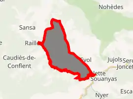
| |
 Oreilla  Oreilla | |
| Coordinates: 42°33′37″N 2°15′16″E | |
| Country | France |
| Region | Occitanie |
| Department | Pyrénées-Orientales |
| Arrondissement | Prades |
| Canton | Les Pyrénées catalanes |
| Government | |
| • Mayor (2008–2014) | Sauveur Cristofol |
| Area 1 | 16.03 km2 (6.19 sq mi) |
| Population (2017-01-01)[1] | 23 |
| • Density | 1.4/km2 (3.7/sq mi) |
| Time zone | UTC+01:00 (CET) |
| • Summer (DST) | UTC+02:00 (CEST) |
| INSEE/Postal code | 66128 /66360 |
| Elevation | 620–2,089 m (2,034–6,854 ft) (avg. 873 m or 2,864 ft) |
| 1 French Land Register data, which excludes lakes, ponds, glaciers > 1 km2 (0.386 sq mi or 247 acres) and river estuaries. | |
Geography
Oreilla is located in the canton of Les Pyrénées catalanes and in the arrondissement of Prades.
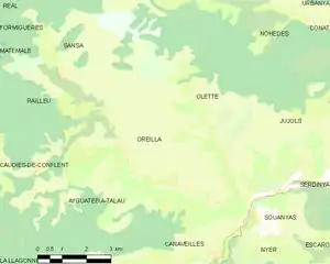
Map of Oreilla and its surrounding communes
History
Oreilla is the commune of France which suffered the highest ratio of losses during the First World War: 20 men were drafted, 18 were killed in action, which represented 13% of the whole population of the village (the national average was 3.53%)[2]
Population
| Year | Pop. | ±% p.a. |
|---|---|---|
| 1968 | 39 | — |
| 1975 | 30 | −3.68% |
| 1982 | 25 | −2.57% |
| 1990 | 27 | +0.97% |
| 1999 | 15 | −6.32% |
| 2007 | 15 | +0.00% |
| 2012 | 13 | −2.82% |
| 2017 | 23 | +12.09% |
| Source: INSEE[3] | ||
References
- "Populations légales 2017". INSEE. Retrieved 6 January 2020.
- "Man dressed as a French soldier of the World war I". www.gettyimages.ca. Retrieved 6 February 2019.
- Population en historique depuis 1968, INSEE
| Wikimedia Commons has media related to Oreilla. |
| Authority control |
|---|
This article is issued from Wikipedia. The text is licensed under Creative Commons - Attribution - Sharealike. Additional terms may apply for the media files.