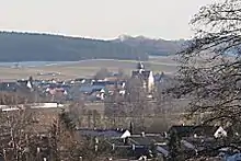
Niederraunau
Niederraunau is a quarter of the town Krumbach in Günzburg (district), Swabia, Bavaria, Germany.

Niederraunau from northwest
Geography
Niederraunau (Elevation 518 m) is in the valley of the little river Kammel two kilometres south of Krumbach in the natural region Lower Iller-Lech Gravel Plateau. The hills between the valleys of Kammel and the neighboring valleys of Günz and Mindel are covered with forest. Niederraunau has a station at the Mittelschwaben Railway and it is at the Bundesstraße 16.
History
- Between 1100 and 1200: Niederraunau was founded
- Between 1494 and 1495: the village got the right to hold a market
- 1613: the village was given a coat of arms
- After World War II: Niederraunau was the site of a post World War II American sector displaced person camp.[1]
- 1978: Niederraunau became a quarter of the town Krumbach; before this time the village was its own municipality.
Sights and attractions
Sights and attractions found in Niederraunau include:
- The castle of Schloss Niederraunau
- The church Hlgst. Dreifaltigkeit (mentioned in the year 1067; was at the beginning romanesque; between 1617 and 1629 the church got its current look)
- A penitence cross from the medieval era at the Bundesstraße 16
- The Ecce Homo Chapel
Companies and organizations
Companies and organizations based in Niederraunau include:
- FAIST Anlagenbau GmbH, a manufacturer of noise control facilities and aero-acoustic wind tunnel treatments
- Scheppach, a manufacturer of building machinery
References
| Wikimedia Commons has media related to Niederraunau. |
This article is issued from Wikipedia. The text is licensed under Creative Commons - Attribution - Sharealike. Additional terms may apply for the media files.