National Weather Service Caribou, Maine
The National Weather Service Caribou, Maine is a local office of the National Weather Service responsible for monitoring weather conditions in northern Maine. It is co-located with an upper air sounding facility but the NEXRAD radar KCBW is near Houlton, Maine, further south.[1]
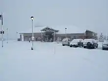
 The office in winter 2011. | |
| Types | branch |
|---|---|
| Location | Caribou |
| Country | United States |
| Coordinates | 46°52′06″N 68°00′49″W |
| Website | www |
Mission
The National Weather Service in Caribou provides weather, hydrologic, and climate forecasts and warnings for northeastern Maine, and adjacent waters for the protection of life and property and the enhancement of the national economy.[2][3]
NOAA Weather Radio
National Weather Service Caribou, Maine forecast office provides programming for eight NOAA Weather Radio stations in Maine.[4]
| City of license | Call sign | Frequency (MHz) | Power |
|---|---|---|---|
| Ellsworth | KEC93 | 162.400 MHz | 1,000 watts |
| Milo | KHB54 | 162.550 MHz | 1,000 watts |
| Frenchville | KHB55 | 162.475 MHz | 300 watts |
| Meddybemps | KHC47 | 162.425 MHz | 300 watts |
| Greenville | WNG542 | 162.425 MHz | 300 watts |
| Jonesboro | WNG543 | 162.450 MHz | 1,000 watts |
| Caribou | WXM77 | 162.525 MHz | 200 watts |
| Springfield | WXN28 | 162.500 MHz | 1,000 watts |
References
- Global Hydrology Resource Center. "GPM Ground Validation NEXRAD GCPEx (KAPX, KBOX, KBUF, KCBW, KCXX, KGYX, KTYX)". NASA.
- "About: Mission". National Weather Service. Retrieved July 2, 2018.
- National Weather Service Forecast Office in Caribou, Me. "Mission". Facebook. Retrieved July 2, 2018.
- NWR Station Listing for Maine, NOAA. Retrieved July 31, 2018.
External links
This article is issued from Wikipedia. The text is licensed under Creative Commons - Attribution - Sharealike. Additional terms may apply for the media files.
