National Register of Historic Places listings in Spencer County, Kentucky
This is a list of the National Register of Historic Places listings in Spencer County, Kentucky.

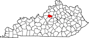
Location of Spencer County in Kentucky
This is intended to be a complete list of the properties and districts on the National Register of Historic Places in Spencer County, Kentucky, United States. The locations of National Register properties and districts for which the latitude and longitude coordinates are included below, may be seen in a Google map.[1]
There are 14 properties and districts listed on the National Register in the county.
- This National Park Service list is complete through NPS recent listings posted February 5, 2021.[2]
Current listings
| [3] | Name on the Register | Image | Date listed[4] | Location | City or town | Description |
|---|---|---|---|---|---|---|
| 1 | All Saints Church |  All Saints Church |
April 2, 1992 (#92000302) |
Eastern side of Main Cross St. between Park Alley and Back Alley 38°02′00″N 85°20′40″W |
Taylorsville | |
| 2 | Beechland |  Beechland |
November 7, 1976 (#76000945) |
2.5 miles north of Taylorsville 38°03′39″N 85°20′23″W |
Taylorsville | |
| 3 | Bourne-Anderson House |  Bourne-Anderson House |
December 2, 1977 (#77000648) |
0.5 miles north of Taylorsville on Kentucky Route 55 38°02′15″N 85°21′04″W |
Taylorsville | |
| 4 | Camp Branch Historic District | February 1, 1994 (#93001594) |
Southwestern side of Kentucky Route 55, 0.2. miles northwest of County Road 1392 37°59′00″N 85°19′27″W |
Taylorsville | ||
| 5 | Isaac Miller Farm | February 1, 1994 (#93001596) |
Northern side of Kentucky Route 48, 0.9 west of Fairfield 37°56′57″N 85°24′05″W |
Fairfield | ||
| 6 | Minor Chapel A.M.E. Church |  Minor Chapel A.M.E. Church |
April 2, 1992 (#92000300) |
Eastern side of Jefferson St. between Red Row Alley and Reasor St. 38°01′59″N 85°20′34″W |
Taylorsville | |
| 7 | Riverview School |  Riverview School |
February 1, 1994 (#93001595) |
Northeastern side of U.S. Route 31E, 1.2 miles north of High Grove 37°59′57″N 85°29′18″W |
High Grove | |
| 8 | L.W. Ross House |  L.W. Ross House |
April 2, 1992 (#92000299) |
Northern side of Kentucky Route 44 east of Taylorsville 38°01′58″N 85°20′17″W |
Taylorsville | |
| 9 | Perry Shelburne House |  Perry Shelburne House |
April 2, 1992 (#92000297) |
Western side of Railroad St., north of Red Row Alley 38°01′58″N 85°20′31″W |
Taylorsville | |
| 10 | Shelburne-Cox House |  Shelburne-Cox House |
April 2, 1992 (#92000298) |
501 Main St. 38°01′55″N 85°20′34″W |
Taylorsville | |
| 11 | Felix Grundy Stidger House |  Felix Grundy Stidger House |
February 12, 2016 (#16000014) |
102 Garrard St. 38°01′47″N 85°20′57″W |
Taylorsville | |
| 12 | Stone House on Plum Creek | January 8, 1987 (#87000213) |
Intersection of Kentucky Routes 1060 and 1319 38°06′07″N 85°26′11″W |
Whitfield | ||
| 13 | Taylorsville Historic District |  Taylorsville Historic District |
April 2, 1992 (#92000296) |
Roughly the 200 and 300 blocks of Main and Garrand Sts. 38°01′50″N 85°20′46″W |
Taylorsville | |
| 14 | Van Dyke House | January 8, 1987 (#87000181) |
Buck Henry Foster Ln. 38°06′11″N 85°18′02″W |
Rivals |
See also
| Wikimedia Commons has media related to National Register of Historic Places in Spencer County, Kentucky. |
References
- The latitude and longitude information provided in this table was derived originally from the National Register Information System, which has been found to be fairly accurate for about 99% of listings. Some locations in this table may have been corrected to current GPS standards.
- "National Register of Historic Places: Weekly List Actions". National Park Service, United States Department of the Interior. Retrieved on February 5, 2021.
- Numbers represent an alphabetical ordering by significant words. Various colorings, defined here, differentiate National Historic Landmarks and historic districts from other NRHP buildings, structures, sites or objects.
- The eight-digit number below each date is the number assigned to each location in the National Register Information System database, which can be viewed by clicking the number.
This article is issued from Wikipedia. The text is licensed under Creative Commons - Attribution - Sharealike. Additional terms may apply for the media files.