National Register of Historic Places listings in Somerset County, Maryland
This is a list of the National Register of Historic Places listings in Somerset County, Maryland.
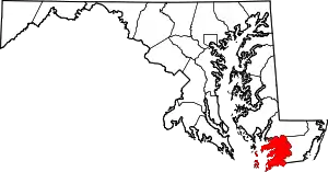
Location of Somerset County in Maryland
This is intended to be a complete list of the properties and districts on the National Register of Historic Places in Somerset County, Maryland, United States. Latitude and longitude coordinates are provided for many National Register properties and districts; these locations may be seen together in a map.[1]
There are 73 properties and districts listed on the National Register in the county.
| Allegany - Anne Arundel - Baltimore (city) - Baltimore County - Calvert - Caroline - Carroll - Cecil - Charles - Dorchester - Frederick - Garrett - Harford - Howard - Kent - Montgomery - Prince George's - Queen Anne's - Somerset - St. Mary's - Talbot - Washington - Wicomico - Worcester |
- This National Park Service list is complete through NPS recent listings posted January 29, 2021.[2]
Current listings
| [3] | Name on the Register[4] | Image | Date listed[5] | Location | City or town | Description |
|---|---|---|---|---|---|---|
| 1 | Academy Grove Historic District | .jpg.webp) Academy Grove Historic District |
May 3, 1984 (#84001863) |
Maryland Route 361 38°05′58″N 75°48′32″W |
Upper Fairmount | |
| 2 | Adams Farm | November 10, 1988 (#88002140) |
Princess Anne-Westover Rd. 38°11′35″N 76°01′48″W |
Princess Anne | ||
| 3 | All Saints Church at Monie | 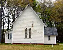 All Saints Church at Monie |
August 3, 1990 (#90001167) |
Venton Rd. northwest of its junction with Deal Island Rd. 38°11′37″N 75°45′55″W |
Venton | |
| 4 | Arlington | May 21, 1992 (#92000588) |
Maryland Route 361 38°07′42″N 75°44′04″W |
Westover | ||
| 5 | Beauchamp House | August 9, 1984 (#84003855) |
Old Westover-Marion Rd. 38°05′26″N 75°42′23″W |
Westover | ||
| 6 | Beckford | 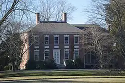 Beckford |
August 13, 1974 (#74000963) |
Beckford Ave. 38°12′02″N 75°41′56″W |
Princess Anne | |
| 7 | Beverly | 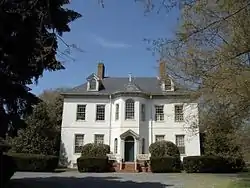 Beverly |
March 30, 1973 (#73000937) |
South of Princess Anne on U.S. Route 13 38°09′27″N 75°41′22″W |
Princess Anne | |
| 8 | Brentwood Farm | September 4, 1986 (#86002174) |
Allen Rd. 38°15′58″N 75°41′22″W |
Westover | ||
| 9 | Caldicott | 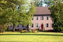 Caldicott |
December 22, 1983 (#83003796) |
Southwest of U.S. Route 13 38°03′13″N 75°39′02″W |
Rehobeth | |
| 10 | Burton Cannon House | April 3, 1975 (#75000916) |
1 mile north of Cokesbury on Dublin Rd. 38°09′04″N 75°35′40″W |
Cokesbury | ||
| 11 | Catalpa Farm | 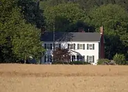 Catalpa Farm |
November 10, 1988 (#88002049) |
Old Princess Anne-Westover Rd. 38°11′09″N 75°40′46″W |
Princess Anne | |
| 12 | Cedar Hill | 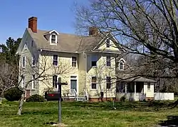 Cedar Hill |
March 14, 1991 (#91000255) |
Eastern side of Sign Post Rd. at Back Creek 38°07′55″N 75°42′42″W |
Westover | |
| 13 | CLARENCE CROCKETT | May 16, 1985 (#85001079) |
Lower Thorofare 38°07′41″N 75°56′54″W |
Wenona | ||
| 14 | Coventry Parish Ruins | 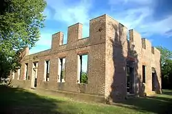 Coventry Parish Ruins |
August 9, 1984 (#84001869) |
Off Maryland Route 667 38°02′18″N 75°39′59″W |
Rehobeth | |
| 15 | Crisfield Armory |  Crisfield Armory |
September 25, 1985 (#85002669) |
Main St. Extended 38°00′29″N 75°50′34″W |
Crisfield | |
| 16 | Crisfield Historic District | 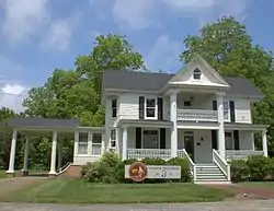 Crisfield Historic District |
July 9, 1990 (#90001018) |
Roughly bounded by Chesapeake Ave., Maryland Ave., 4th and Cove Sts., including area between Asbury Ave. and E. Main St. 37°58′53″N 75°50′57″W |
Crisfield | |
| 17 | Cullen Homestead Historic District |  Cullen Homestead Historic District |
November 18, 2009 (#09000932) |
4533, 27049, and 27067 Lawson Barnes Rd. 38°00′27″N 75°49′07″W |
Crisfield | |
| 18 | Deal Island Historic District | September 6, 2006 (#06000780) |
Deal Island Rd. from Upper Thorofare to Ballard Rd. and intersecting Sts. 38°09′38″N 75°56′49″W |
Deal Island | ||
| 19 | F.C. LEWIS, JR | May 16, 1985 (#85001080) |
Lower Thorofare 38°07′41″N 75°56′54″W |
Wenona | ||
| 20 | FANNIE L. DAUGHERTY |  FANNIE L. DAUGHERTY |
May 16, 1985 (#85001081) |
Lower Thorofare 38°07′41″N 75°56′54″W |
Wenona | |
| 21 | Glebe House | November 18, 2009 (#09000933) |
10950 Market Lane 38°10′51″N 75°41′25″W |
Princess Anne | ||
| 22 | Grace Episcopal Church | 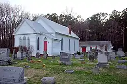 Grace Episcopal Church |
November 1, 1990 (#90001565) |
Mt. Vernon Rd. north of its junction with Ridge Rd. 38°14′36″N 75°46′09″W |
Mt. Vernon | |
| 23 | Harrington | September 11, 1975 (#75000918) |
Northwest of Princess Anne off Maryland Route 362 38°15′41″N 75°45′33″W |
Princess Anne | ||
| 24 | Jeptha Hayman House |  Jeptha Hayman House |
December 27, 1990 (#90001939) |
Westover-Marion Rd. south of its junction with Charles Barnes Rd. 38°04′08″N 75°42′26″W |
Kingston | |
| 25 | Hayward's Lott | 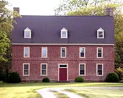 Hayward's Lott |
May 13, 1976 (#76001009) |
1.75 miles northwest of Pocomoke City on Hayward Rd. 38°05′35″N 75°35′21″W |
Pocomoke City | |
| 26 | HOWARD (Skipjack) | May 16, 1985 (#85001082) |
Lower Thorofare 38°07′41″N 75°56′54″W |
Wenona | ||
| 27 | IDA MAY |  IDA MAY |
May 16, 1985 (#85001077) |
Upper Thorofare 38°10′10″N 75°56′49″W |
Chance | |
| 28 | ISLAND BELLE | March 16, 1979 (#79001141) |
Ewell 37°59′47″N 76°01′44″W |
Smith Island | ||
| 29 | Kingston Hall | 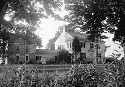 Kingston Hall |
December 31, 1974 (#74000962) |
Western side of Maryland Route 667, 0.5 miles from Kingston 38°05′11″N 75°43′08″W |
Kingston | |
| 30 | Lankford House | August 9, 1984 (#84001870) |
Maryland Route 667 38°03′04″N 75°42′21″W |
Marion | ||
| 31 | Liberty Hall | December 27, 1976 (#76001012) |
South of Westover off Maryland Route 361 38°05′35″N 75°43′48″W |
Westover | ||
| 32 | George Maddox Farm | September 17, 1985 (#85002410) |
River Rd. 38°05′59″N 75°45′05″W |
Manokin | ||
| 33 | Maddux House | December 27, 2002 (#02001574) |
9084 Maddox Island Rd. 38°07′59″N 75°47′44″W |
Upper Fairmount | ||
| 34 | Make Peace | 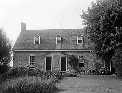 Make Peace |
November 20, 1975 (#75000917) |
1.5 miles southeast of Crisfield on Johnson's Creek Rd. 37°58′25″N 75°49′13″W |
Crisfield | |
| 35 | Manokin Historic District | June 29, 1976 (#76001010) |
Southwest of Princess Anne at the Manokin River 38°09′16″N 75°47′22″W |
Princess Anne | ||
| 36 | Manokin Presbyterian Church | .jpg.webp) Manokin Presbyterian Church |
November 21, 1976 (#76001011) |
N. Somerset Ave. 38°12′27″N 75°41′43″W |
Princess Anne | |
| 37 | Mt. Zion Memorial Church | 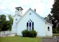 Mt. Zion Memorial Church |
November 1, 2007 (#07001116) |
29071 Polks Rd. 38°15′37″N 75°44′38″W |
Princess Anne | |
| 38 | Nelson Homestead |  Nelson Homestead |
September 12, 1985 (#85002175) |
Cash Corner and Hopewell-Bedsworth Rds. 37°59′29″N 75°49′38″W |
Crisfield | |
| 39 | Panther's Den | March 22, 1984 (#84001872) |
Drawbridge Rd. 38°12′12″N 75°47′25″W |
Venton | ||
| 40 | Pomfret Plantation | September 7, 1984 (#84001874) |
Maryland Route 667 38°02′31″N 75°48′06″W |
Marion Station | ||
| 41 | Princess Anne Historic District | 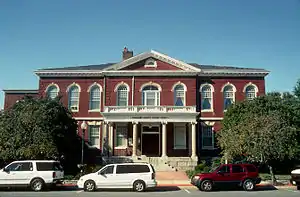 Princess Anne Historic District |
October 14, 1980 (#80001834) |
Off Maryland Route 413 38°12′14″N 75°41′38″W |
Princess Anne | |
| 42 | Dr. William B. Pritchard House | August 8, 1996 (#96000879) |
29994 Polks Rd. 38°15′49″N 75°42′36″W |
Princess Anne | ||
| 43 | Puncheon Mill House | 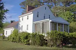 Puncheon Mill House |
July 27, 1994 (#94000763) |
Puncheon Landing Rd. 38°04′35″N 75°36′26″W |
Pocomoke City | |
| 44 | Quindocqua United Methodist Church |  Quindocqua United Methodist Church |
March 28, 1996 (#96000313) |
Junction of Quindocqua, Whittington, and L.Q. Powell Rds. 38°01′02″N 75°44′58″W |
Marion Station | |
| 45 | Rehobeth Presbyterian Church | 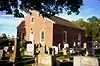 Rehobeth Presbyterian Church |
November 5, 1974 (#74000964) |
South of Rehobeth off Maryland Route 667 38°02′21″N 75°39′53″W |
Rehobeth | |
| 46 | Reward | August 13, 1974 (#74000965) |
Southeast of Shelltown on Williams Point Rd. 37°57′24″N 75°39′26″W |
Shelltown | ||
| 47 | Rock Creek Methodist Episcopal Church | November 2, 1990 (#90001718) |
Deal Island Rd. northeast of Scotts Cove 38°10′35″N 75°56′12″W |
Chance | ||
| 48 | Salisbury Plantation | June 20, 1975 (#75000919) |
Southwest of Westover off Maryland Route 361 38°05′18″N 75°44′13″W |
Westover | ||
| 49 | Schoolridge Farm | September 7, 1984 (#84001876) |
Maryland Route 361 38°05′53″N 75°48′19″W |
Upper Fairmount | ||
| 50 | SEA GULL | May 16, 1985 (#85001078) |
Lower thorofare 38°07′41″N 75°56′54″W |
Deal Island | ||
| 51 | William S. Smith House | July 9, 1991 (#91000891) |
Southern side of Oriole Rd., east of its junction with Crab Island Rd. 38°10′22″N 75°48′56″W |
Oriole | ||
| 52 | Somerset Academy Archaeological Site |  Somerset Academy Archaeological Site |
September 11, 1986 (#86002356) |
Address Restricted |
Princess Anne | |
| 53 | St. John's Methodist Episcopal Church and Joshua Thomas Chapel | November 1, 1990 (#90001550) |
Deal Island Rd. north of its junction with Tangier Rd. 38°09′19″N 75°56′50″W |
Deal Island | ||
| 54 | St. Mark's Episcopal Church | 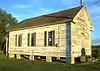 St. Mark's Episcopal Church |
October 25, 1990 (#90001569) |
Junction of Westover-Marion and Charles Barnes Rds. 38°04′21″N 75°42′35″W |
Kingston | |
| 55 | St. Paul's Methodist Episcopal Church | April 12, 1996 (#96000403) |
Junction of Maryland Route 413 and Sign Rd. 38°07′23″N 75°42′26″W |
Westover | ||
| 56 | St. Paul's Protestant Episcopal Church |  St. Paul's Protestant Episcopal Church |
August 3, 1990 (#90001153) |
Near the junction of Farm Market Rd. and St. Pauls Church Rd. 38°00′56″N 75°46′14″W |
Tulls Corner | |
| 57 | St. Peter's Methodist Episcopal Church |  St. Peter's Methodist Episcopal Church |
November 2, 1990 (#90001721) |
Junction of Old Crisfield-Marion Rd. and Heart's Ease Rd. 38°01′01″N 75°49′13″W |
Hopewell | |
| 58 | Sudler's Conclusion | 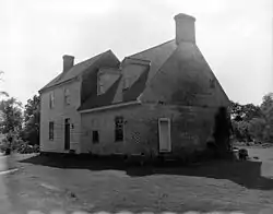 Sudler's Conclusion |
August 28, 1973 (#73000936) |
Northwest of Manokin off Maryland Route 361 38°07′16″N 75°46′37″W |
Manokin | |
| 59 | SUSAN MAY | May 16, 1985 (#85001083) |
Lower Thorofare 38°07′41″N 75°56′54″W |
Wenona | ||
| 60 | Capt. Leonard Tawes House | 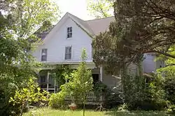 Capt. Leonard Tawes House |
April 5, 1990 (#90000598) |
Somerset Ave. 37°58′32″N 75°50′43″W |
Crisfield | |
| 61 | Teackle Mansion | _2.jpg.webp) Teackle Mansion |
October 26, 1971 (#71000378) |
Mansion St. 38°12′12″N 75°42′08″W |
Princess Anne | |
| 62 | THOMAS W. CLYDE | 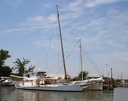 THOMAS W. CLYDE |
May 16, 1985 (#85001084) |
Lower Thorofare 38°07′41″N 75°56′54″W |
Wenona | |
| 63 | Tudor Hall | December 19, 1974 (#74000966) |
Southeast of Upper Fairmount off Maryland Route 361 38°05′52″N 75°46′31″W |
Upper Fairmount | ||
| 64 | William T. Tull House |  William T. Tull House |
March 26, 1996 (#96000302) |
Along the western side of Maryland Route 413 38°07′32″N 75°42′22″W |
Westover | |
| 65 | University of Maryland Eastern Shore | University of Maryland Eastern Shore |
September 16, 2005 (#05001021) |
1 Backbone Rd. 38°12′29″N 75°41′09″W |
Princess Anne | |
| 66 | Upper Fairmount Historic District |  Upper Fairmount Historic District |
September 13, 1993 (#93000900) |
Both sides of Maryland Route 361 38°06′25″N 75°48′01″W |
Upper Fairmount | |
| 67 | Waddy House | November 3, 1988 (#88002221) |
Perryhawkin Rd. 38°11′37″N 75°38′54″W |
Princess Anne | ||
| 68 | Ward Brothers' House and Shop | .jpg.webp) Ward Brothers' House and Shop |
November 21, 1997 (#94000790) |
3199 Sackertown Rd. 37°58′13″N 75°50′42″W |
Crisfield | |
| 69 | Waterloo | 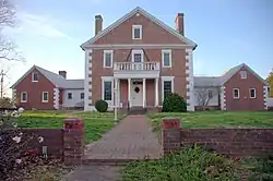 Waterloo |
February 13, 1986 (#86000257) |
Mt. Vernon Rd. 38°13′35″N 75°45′09″W |
Princess Anne | |
| 70 | Waters' River | August 9, 1984 (#84001882) |
Hood Rd. 38°05′54″N 75°45′50″W |
Manokin | ||
| 71 | Watkins Point Farm |  Watkins Point Farm |
December 27, 2002 (#02001586) |
27737 Phoenix Church Rd. 37°58′51″N 75°47′28″W |
Marion Station | |
| 72 | White Hall | 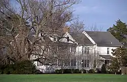 White Hall |
June 7, 1984 (#84003868) |
Cooley Rd. 38°15′59″N 75°43′23″W |
Princess Anne | |
| 73 | Williams' Conquest | May 3, 1984 (#84001886) |
Charles Cannon Rd. 38°04′23″N 75°45′43″W |
Marion Station |
Former listings
| [3] | Name on the Register | Image | Date listed | Date removed | Location | City or town | Summary |
|---|---|---|---|---|---|---|---|
| 1 | William Costen House | 1985 (#85000654) | July 25, 1994 | Courthouse Hill Road |
Wellington vicinity |
See also
| Wikimedia Commons has media related to National Register of Historic Places in Somerset County, Maryland. |
References
- The latitude and longitude information provided in this table was derived originally from the National Register Information System, which has been found to be fairly accurate for about 99% of listings. Some locations in this table may have been corrected to current GPS standards.
- "National Register of Historic Places: Weekly List Actions". National Park Service, United States Department of the Interior. Retrieved on January 29, 2021.
- Numbers represent an alphabetical ordering by significant words. Various colorings, defined here, differentiate National Historic Landmarks and historic districts from other NRHP buildings, structures, sites or objects.
- "National Register Information System". National Register of Historic Places. National Park Service. April 24, 2008.
- The eight-digit number below each date is the number assigned to each location in the National Register Information System database, which can be viewed by clicking the number.
| Topics |  | |
|---|---|---|
| Lists by county | ||
| Lists by city | ||
| Other lists | ||
| ||
Municipalities and communities of Somerset County, Maryland, United States | ||
|---|---|---|
| City | | |
| Town | ||
| CDPs | ||
| Other communities | ||
| ||
This article is issued from Wikipedia. The text is licensed under Creative Commons - Attribution - Sharealike. Additional terms may apply for the media files.