National Register of Historic Places listings in Albany County, Wyoming
This is a list of the National Register of Historic Places listings in Albany County, Wyoming. It is intended to be a complete list of the properties and districts on the National Register of Historic Places in Albany County, Wyoming, United States. The locations of National Register properties and districts for which the latitude and longitude coordinates are included below, may be seen in a map.[1]

Location of Albany County in Wyoming
There are 41 properties and districts listed on the National Register in the county, of which one is also a National Historic Landmark.
- This National Park Service list is complete through NPS recent listings posted February 5, 2021.[2]
| Albany - Big Horn - Campbell - Carbon - Converse - Crook - Fremont - Goshen - Hot Springs - Johnson - Laramie - Lincoln - Natrona - Niobrara - Park - Platte - Sheridan - Sublette - Sweetwater - Teton - Uinta - Washakie - Weston |
Current listings
| [3] | Name on the Register | Image | Date listed[4] | Location | City or town | Description |
|---|---|---|---|---|---|---|
| 1 | Ames Monument | .jpg.webp) Ames Monument |
July 24, 1972 (#72001296) |
3 miles northwest of Sherman 41°07′53″N 105°23′51″W |
Sherman | Designated a National Historic Landmark in 2016. |
| 2 | Barn at Oxford Horse Ranch |  Barn at Oxford Horse Ranch |
June 25, 1986 (#86001398) |
868 U.S. Route 287 41°11′18″N 105°35′32″W |
Laramie | |
| 3 | Bath Ranch |  Bath Ranch |
December 13, 1985 (#85003211) |
Herrick Lane Rd. 41°24′16″N 105°49′33″W |
Laramie | |
| 4 | Bath Row | .JPG.webp) Bath Row |
May 8, 1986 (#86001015) |
155, 157, and 159 N. 6th St. and 611 University Ave. 41°18′46″N 105°35′19″W |
Laramie | |
| 5 | Charles E. Blair House |  Charles E. Blair House |
October 31, 1980 (#80004298) |
170 N. 5th St. 41°18′49″N 105°35′26″W |
Laramie | |
| 6 | N.K. Boswell Ranch | July 21, 1977 (#77001381) |
South of Woods Landing off Wyoming Highway 230 41°00′08″N 106°00′52″W |
Woods Landing | ||
| 7 | Brooklyn Lodge |  Brooklyn Lodge |
October 24, 1989 (#89001068) |
Wyoming Highway 130, 7.5 miles west of Centennial 41°21′21″N 106°13′57″W |
Centennial | |
| 8 | Centennial Depot | 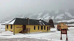 Centennial Depot |
November 8, 1982 (#82001828) |
Wyoming Highway 130 41°17′49″N 106°08′13″W |
Centennial | Now the Nici Self Historical Museum. |
| 9 | Centennial Work Center | 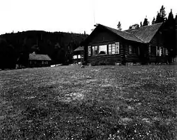 Centennial Work Center |
April 11, 1994 (#94000273) |
Off Wyoming Highway 130 northwest of Centennial, Medicine Bow National Forest 41°18′28″N 106°09′25″W |
Centennial | |
| 10 | Como Bluff | 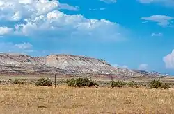 Como Bluff |
January 18, 1973 (#73001925) |
On U.S. Route 30, along Como Ridge 41°53′13″N 106°03′24″W |
Rock River | Extends into Carbon County |
| 11 | John D. Conley House | 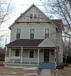 John D. Conley House |
May 15, 1980 (#80004299) |
718 Ivinson St. 41°18′41″N 105°35′14″W |
Laramie | |
| 12 | Cooper Mansion | .JPG.webp) Cooper Mansion |
August 8, 1983 (#83003359) |
1411 Grand Ave. 41°18′38″N 105°34′38″W |
Laramie | Referred to as Cooper House by its owner, the University of Wyoming, it houses the University's American Studies Program. |
| 13 | Dale Creek Crossing (48AB145) | Dale Creek Crossing (48AB145) |
May 9, 1986 (#86001027) |
4 miles west of Sherman 41°06′15″N 105°27′17″W |
Ames Monument | |
| 14 | DOE Bridge over Laramie River | 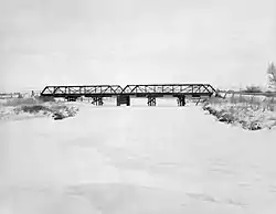 DOE Bridge over Laramie River |
February 22, 1985 (#85000411) |
County Road CNA-740 41°35′32″N 105°39′23″W |
Bosler | Replaced in 1993 |
| 15 | Durlacher House | .jpg.webp) Durlacher House |
March 21, 2011 (#11000097) |
501 S. 5th St. 41°18′32″N 105°35′28″W |
Laramie | |
| 16 | East Side School | East Side School |
March 17, 1981 (#81000610) |
Off U.S. Route 30 41°18′33″N 105°35′14″W |
Laramie | Located at 710 East Garfield Street. |
| 17 | First National Bank of Rock River | 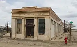 First National Bank of Rock River |
November 21, 1988 (#88002532) |
131 Ave. C 41°44′37″N 105°58′43″W |
Rock River | |
| 18 | Flying Horseshoe Ranch | October 12, 2000 (#00001226) |
156 Dinwiddie Rd. 41°16′13″N 106°06′53″W |
Centennial | ||
| 19 | Fort Sanders Guardhouse | Fort Sanders Guardhouse |
May 1, 1980 (#80004300) |
Kiowa St. 41°16′27″N 105°35′56″W |
Laramie | |
| 20 | William Goodale House | 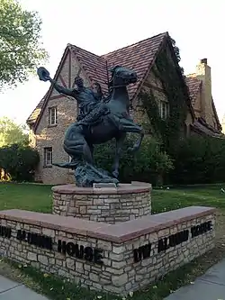 William Goodale House |
August 5, 1991 (#91000996) |
214 S. 14th St. 41°18′37″N 105°34′48″W |
Laramie | |
| 21 | Ivinson Mansion and Grounds | 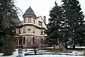 Ivinson Mansion and Grounds |
February 23, 1972 (#72001295) |
603 Ivinson Ave.[5] 41°18′44″N 105°35′18″W |
Laramie | |
| 22 | Jelm-Frank Smith Ranch Historic District | August 31, 1978 (#78002816) |
South of Woods Landing 41°03′33″N 106°00′41″W |
Woods Landing | ||
| 23 | Keystone Work Center | April 11, 1994 (#94000275) |
West of Albany, Medicine Bow National Forest 41°10′09″N 106°14′55″W |
Albany | ||
| 24 | F.S. King Brothers Ranch Historic District | 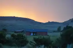 F.S. King Brothers Ranch Historic District |
September 21, 2006 (#06000874) |
Address Restricted |
Laramie | |
| 25 | Laramie Downtown Historic District | 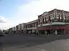 Laramie Downtown Historic District |
November 10, 1988 (#88002541) |
Roughly bounded by University Ave., 6th St., Grand Ave., 3rd St., Garfield Ave., and 1st Ave. 41°18′35″N 105°35′38″W |
Laramie | |
| 26 | Lehman-Tunnell Mansion | 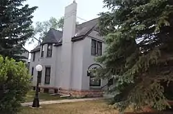 Lehman-Tunnell Mansion |
November 8, 1982 (#82001829) |
618 Grand Ave. 41°18′38″N 105°35′18″W |
Laramie | |
| 27 | Libby Lodge |  Libby Lodge |
September 30, 1976 (#76001947) |
Northwest of Centennial on Wyoming Highway 130 41°19′20″N 106°10′19″W |
Centennial | |
| 28 | Lincoln School | 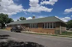 Lincoln School |
December 5, 2003 (#03001252) |
209 S. Cedar St. 41°18′43″N 105°35′58″W |
Laramie | |
| 29 | Mountain View Hotel | Mountain View Hotel |
June 7, 2007 (#07000541) |
2747 Wyoming Highway 130 41°17′52″N 106°08′24″W |
Centennial | |
| 30 | North Albany Clubhouse |  North Albany Clubhouse |
July 23, 1998 (#98000908) |
Address Restricted 41°57′40″N 105°33′59″W |
Garrett | Provided coordinates show a small building at the intersection of Garrett and Tunnel Roads |
| 31 | Old Main |  Old Main |
July 11, 1986 (#86001536) |
University of Wyoming campus, 9th St. and Ivinson Ave. 41°18′43″N 105°35′02″W |
Laramie | |
| 32 | Parker Ranch House | Parker Ranch House |
December 13, 1985 (#85003209) |
Address Restricted |
Laramie Peak | |
| 33 | Richardson's Overland Trail Ranch |  Richardson's Overland Trail Ranch |
March 5, 1992 (#92000122) |
111 Hart Rd. 41°14′29″N 105°42′06″W |
Laramie | |
| 34 | St. Matthew's Cathedral Close |  St. Matthew's Cathedral Close |
April 12, 1984 (#84003622) |
104 S. 4th St. 41°18′45″N 105°35′33″W |
Laramie | |
| 35 | St. Paulus Kirche | 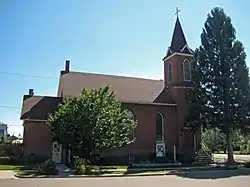 St. Paulus Kirche |
November 25, 1983 (#83004266) |
602 Garfield 41°18′35″N 105°35′20″W |
Laramie | Now known as St. Paul's United Church of Christ of Laramie |
| 36 | Snow Train Rolling Stock | 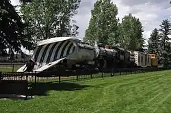 Snow Train Rolling Stock |
May 8, 2013 (#13000265) |
S. 1st & E. Sheridan Sts. 41°18′27″N 105°35′47″W |
Laramie | |
| 37 | Union Pacific Athletic Club | Union Pacific Athletic Club |
September 13, 1978 (#78002814) |
Off U.S. Route 30 41°19′16″N 105°32′49″W |
Laramie | Now the Quadra Dangle Square Dance Club. The address is 3905 East Grays Gable Road |
| 38 | University Neighborhood Historic District | 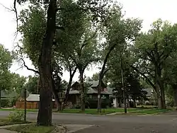 University Neighborhood Historic District |
December 18, 2009 (#09001109) |
Roughly bounded by 6th St., 15th St., University Ave., and Custer St. 41°18′37″N 105°34′59″W |
Laramie | |
| 39 | Vee Bar Ranch Lodge |  Vee Bar Ranch Lodge |
June 30, 1986 (#86001468) |
2087 Wyoming Highway 130 41°17′49″N 106°00′42″W |
Laramie | |
| 40 | Woods Landing Dance Hall |  Woods Landing Dance Hall |
December 13, 1985 (#85003210) |
2731 Wyoming Highway 230 41°06′37″N 106°00′44″W |
Woods Landing | |
| 41 | Wyoming Territorial Penitentiary |  Wyoming Territorial Penitentiary |
March 29, 1978 (#78002815) |
Off Wyoming Highway 130 41°18′45″N 105°36′32″W |
Laramie |
See also
| Wikimedia Commons has media related to National Register of Historic Places in Albany County, Wyoming. |
References
- The latitude and longitude information provided in this table was derived originally from the National Register Information System, which has been found to be fairly accurate for about 99% of listings. Some locations in this table may have been corrected to current GPS standards.
- "National Register of Historic Places: Weekly List Actions". National Park Service, United States Department of the Interior. Retrieved on February 5, 2021.
- Numbers represent an alphabetical ordering by significant words. Various colorings, defined here, differentiate National Historic Landmarks and historic districts from other NRHP buildings, structures, sites or objects.
- The eight-digit number below each date is the number assigned to each location in the National Register Information System database, which can be viewed by clicking the number.
- Location derived from its HABS listing; the NRIS gives its address as "Lots 1-8, block 178"
Wyoming State Historical Preservation Office
| Topics | |
|---|---|
| Lists by state |
|
| Lists by insular areas | |
| Lists by associated state | |
| Other areas | |
| Related | |
| |
Municipalities and communities of Albany County, Wyoming, United States | ||
|---|---|---|
| City | | |
| Town | ||
| CDPs | ||
| Unincorporated communities | ||
| ||
This article is issued from Wikipedia. The text is licensed under Creative Commons - Attribution - Sharealike. Additional terms may apply for the media files.