National Highway 169A (India)
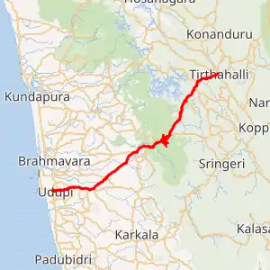
National Highway 169A (NH 169A) is a National Highway in India, which comes under Ministry of Road Transport & Highways, Government of India.[1][2] The highway starts from Malpe harbour in Udupi and ends at Thirthahalli. Though classified as national highway the width of this road is very less at many stretches. The stretches where road width is very less are Malpe to Karavali By-pass , Manipal to Perdoor and Someshwara to Agumbe where only mini buses and mini lorry are allowed. The NH-169A ascends Agumbe ghat section of Western ghats of India (Bharat).
| ||||
|---|---|---|---|---|

Map of the National Highway in red | ||||
| Route information | ||||
| Length | 87 km (54 mi) | |||
| Major junctions | ||||
| From | Thirthahalli | |||
| To | Udupi | |||
| Location | ||||
| Primary destinations | Agumbe - Hebri | |||
| Highway system | ||||
| ||||
Route
Thirthahalli -Nalur- Agumbe - Hebri - Someshwara - Shivapura - Perdoor - Hiryadka - Parkala, Udupi - Manipal in Udupi - Udupi City - Malpe Harbour (Udupi).[3][4][5]
See also
- List of National Highways in India
- List of National Highways in India by state
- Ghat Roads
References
- "Rationalisation of Numbering Systems of National Highways" (PDF). New Delhi: Department of Road Transport and Highways. Archived from the original (PDF) on 1 February 2016. Retrieved 3 April 2012.
- "NH 169A slicing Udupi city". The Hindu. 5 March 2014. Retrieved 14 July 2018.
- "New highways notification NH 169A" (PDF). The Gazette of India - Ministry of Road Transport and Highways. Retrieved 14 July 2018.
- "NH 169A - Route corrigendum" (PDF). Retrieved 14 July 2018.
- "State-wise length of National Highways (NH) in India as on 30.06.2017". Ministry of Road Transport and Highways. Retrieved 14 July 2018.
External links
This article is issued from Wikipedia. The text is licensed under Creative Commons - Attribution - Sharealike. Additional terms may apply for the media files.


