Mukono Town
Mukono Town is a municipality in Mukono District in the Central Region of Uganda. The town is administered by the Mukono Town Council. The district headquarters are located in this town.[2] Mukono Town has links to the English town Guildford.
Mukono | |
|---|---|
 Mukono, Uganda | |
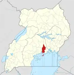
 Mukono Map of Uganda showing the location of Mukono. | |
| Coordinates: 00°21′36″N 32°45′00″E | |
| Country | Uganda |
| Region | Central Region |
| District | Mukono District |
| Area | |
| • Total | 31.4 km2 (12.1 sq mi) |
| Elevation | 1,200 m (3,900 ft) |
| Population (2014 Census) | |
| • Total | 161,996[1] |
| • Density | 5,159/km2 (13,360/sq mi) |
| Time zone | UTC+3 (EAT) |
Location
Mukono Municipality is 21 km east of Kampala along the Kampala- Jinja Highway.It is bordered by Kalagi to the north, Kira Town to the west, Lake Victoria to the south, and Lugazi to the east.[3] The town is 27 kilometres (17 mi) east of the central business district of Kampala, Uganda's capital and largest city.[4] The town occupies approximately 31.4 square kilometres (12.1 sq mi) of land area.[3] The coordinates of the town of Mukono are 00 21 36N, 32 45 00E (Latitude:0.3600; Longitude:32.7500).[5]
Demographics
Mukono is one of Uganda's fastest growing urban areas.[6] The 2002 national census estimated the population of the town at 46,506. In 2010, the Uganda Bureau of Statistics (UBOS) estimated the population at 57,400. In 2011, UBOS estimated the mid-year population at 59,000.[7] On 27 August 2014, the national population census put the population at 161,996.[1]
Administrative units
Administratively, Mukono is divided into four wards: Ggulu, Nsuube, Namumira, and Ntaawo.
Organizational structure
The political head of the town is the mayor who is elected to a five-year term by universal adult suffrage using a secret ballot across all the four wards. The supreme policy-making organ in the town is the town council, composed of 28 elected councilors. Members of the town council serve four-year terms. The technical staff of the town council are headed by the town clerk under whom there are four municipal departments: the Management Department, the Treasury Department, the Public Health Department, and the Engineering Department.
Points of interest
The following additional points of interest are located within the town limits or close to its edges:
- Mukono Central Market
- Uganda Christian University, a private university affiliated to the Church of Uganda
- Namilyango College - the oldest boys boarding high school in Uganda, located 8 kilometres (5.0 mi), by road, south-west of Mukono
- Kampala-Jinja Highway, passing through the center of town in a west to east direction.
- Mukono Health Centre IV
- Abacus Parenteral Drugs Limited, a pharmaceutical company that manufactures intravenous fluids and sterile water for use in injections, ear drops, and eye drops.[8]
- Various supermarkets located among the Kampala-Jinja highway, most notably City Shoppers, Sombe Supermarket and Paris Corner Supermarket.
- Greater Mukono Tourism and Conservation Centre
References
- UBOS (27 August 2014). "The Population of The Regions of the Republic of Uganda And All Cities And Towns of More Than 15,000 Inhabitants". Citypopulation.de Quoting Uganda Bureau of Statistics (UBOS). Retrieved 22 February 2015.
- Mayamba, Johnson (13 January 2014). "Mukono: The King's Hand". Daily Monitor. Retrieved 16 April 2014.
- "NECOC - Home". www.necoc-opm.go.ug. Retrieved 2020-05-24.
- "Map Showing Kampala And Mukono With Distance Marker". Globefeed.com. Retrieved 15 April 2014.
- Google (1 July 2015). "Location of Mukono At Google Maps" (Map). Google Maps. Google. Retrieved 1 July 2015.
- "National Planning Authority – Planning for Development". Retrieved 2020-05-24.
- UBS. "Estimated Population of Mukono Town In 2002, 2010 & 2011" (PDF). Uganda Bureau of Statistics (UBS). Archived from the original (PDF) on 19 January 2013. Retrieved 16 April 2014.
- Nakaweesi, Dorothy (25 January 2010). "Abacus Parenteral Crowned 2009 Investor of The Year". Retrieved 16 April 2014.
