Mount Mee, Queensland
Mount Mee is a rural town and locality in the Moreton Bay Region, Queensland, Australia.[2][3] In the 2016 census, Mount Mee had a population of 484 people.[1]
| Mount Mee Queensland | |||||||||||||||
|---|---|---|---|---|---|---|---|---|---|---|---|---|---|---|---|
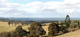
 Panorama from Mount Mee lookout | |||||||||||||||
 Mount Mee | |||||||||||||||
| Coordinates | 27.0588°S 152.7666°E | ||||||||||||||
| Population | 484 (2016 census)[1] | ||||||||||||||
| • Density | 6.245/km2 (16.175/sq mi) | ||||||||||||||
| Established | 1873 | ||||||||||||||
| Postcode(s) | 4521 | ||||||||||||||
| Elevation | 501 m (1,644 ft) | ||||||||||||||
| Area | 77.5 km2 (29.9 sq mi) | ||||||||||||||
| Time zone | AEST (UTC+10:00) | ||||||||||||||
| Location |
| ||||||||||||||
| LGA(s) | Moreton Bay Region | ||||||||||||||
| State electorate(s) | Glass House | ||||||||||||||
| Federal Division(s) | Longman | ||||||||||||||
| |||||||||||||||
Geography
Mount Mee is a mountain, located north of the town of Dayboro in the D'Aguilar Range.
History
The area around Mount Mee was known to the indigenous inhabitants of the area as Dahmongah, a word meaning "flying squirrel" or glider.[4] The English name Mount Mee is possibly derived from another local word mia-mia, meaning a view or lookout, but this name was not formalised until the establishment of the school in 1899.[2][5]
Settlers began arriving in the area around Mount Mee in 1873, many being timber-getters attracted by the red cedar timber that was readily available in the area.[4] Initially, timber cut down in the area was exported to the nearby towns of Caboolture, D'Aguilar and Woodford, but a sawmill was eventually built in the fledgling town. A number of larger mills were operated on various parts of the mountain until the last closed in 1982.[4]
Dahmongah Provisional School opened on 20 February 1884. In 1900 it was renamed Mount Mee Provisional School. It closed in 1904 due to low student numbers but opened again in 1909. On 1 October 1909 it became Mount Mee State School.[6]
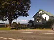
Mount Mee Methodist Church was consecrated on 16 December 1922.[7][8] As at 2020, it is a community church which can be used for any Christian purpose.[9]
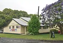
Mount Mee Public Hall opened in 1933.[10]
A special tractor called the Linn tractor was used to haul logs instead of bullock teams in the early 1930s.[4] Over time, agriculture became important to the economy of the area, with dairy farms and banana plantations being particularly important.[4][5]
Mount Mee Banana Settlement State School opened on 4 April 1934 and closed circa 1939.[6]
Mount Mee was initially governed as a part of the Caboolture Divisional Board, but was rolled into the new Moreton Bay Region when that entity was amalgamated with Pine Rivers Shire and Redcliffe City in 2008.[11]
Demographics
In the 2016 census, Mount Mee recorded a population of 484 people, 49.9% female and 50.1% male.[1] The median age of the Mount Mee population was 49 years, 11 years above the national median of 38. 73.6% of people living in Mount Mee were born in Australia. The other top responses for country of birth were England 5.7%, Scotland 1.5%, New Zealand 1.3%, Germany and Netherlands 0.8%. 84.9% of people spoke only English at home; the next most common languages were 0.6% Spanish and Slovene.[1]
State Forest and Forest Reserve
Mount Mee State Forest and Forest Reserve is a nature preserve located in Mount Mee. It features eucalyptus forests, small sections of rainforest, and plantations of Hoop Pine.[12] They adjoin the Brisbane Forest Park. The park features six different walking tracks, two picnic grounds, a camping ground, and numerous tracks for offroad driving.[13]
Education
Mount Mee State School is a government primary (Prep-6) school for boys and girls at 1368 Mt Mee Road (27.0806°S 152.7711°E).[14][15] In 2017, the school had an enrolment of 72 students with 9 teachers (5 full-time equivalent) and 5 non-teaching staff (3 full-time equivalent).[16]
Amenities


The Moreton Bay Regional Council operates a mobile library service which visits near the Mount Mee Public Hall at 1352 Mount Mee Road (27.0806°S 152.7719°E).[17] The council also operates the hall with the assistance of local volunteers.[10]
The Mount Mee Community Church is shared by a number of denominations (Anglican, Catholic, Lutheran and Uniting Churches). A weekly service is held at the church by one denomination on a roster system. It is at 1345 Mount Mee Road (27.0806°S 152.7727°E) across the road from the Community Hall. It has excellent views from the mountain.[9][18]
Attractions
The Pitstop Cafe has excellent views, a large range of automotive and racing memorabilia and food.[19]
References
- Australian Bureau of Statistics (27 June 2017). "Mount Mee (SSC)". 2016 Census QuickStats. Retrieved 20 October 2018.

- "Mount Mee – town in Moreton Bay Region (entry 23091)". Queensland Place Names. Queensland Government. Retrieved 16 November 2019.
- "Mount Mee – locality in Moreton Bay Region (entry 45489)". Queensland Place Names. Queensland Government. Retrieved 16 November 2019.
- Horton, Helen (1988). Brisbane's Back Door: The story of the D'Aguilar Range. Bowen Hills, Queensland: Boolarong Publications. pp. 64–71. ISBN 0-86439-036-X.
- "Caboolture Town History". Archived from the original on 28 May 2008. Retrieved 6 May 2008.
- Queensland Family History Society (2010), Queensland schools past and present (Version 1.01 ed.), Queensland Family History Society, ISBN 978-1-921171-26-0
- "NEWS FROM THE COUNTRY". The Daily Mail. Queensland, Australia. 23 December 1922. p. 13. Retrieved 6 June 2020 – via Trove.
- "Mt. Mee Methodist Church". The Brisbane Courier. Queensland, Australia. 11 January 1923. p. 15. Retrieved 6 June 2020 – via Trove.
- "Mount Mee Church". Mount Mee. Archived from the original on 6 June 2020. Retrieved 6 June 2020.
- "Mount Mee Public Hall". Mount Mee. Archived from the original on 6 June 2020. Retrieved 6 June 2020.
- "Amalgamations to cut half Qld's local councils". ABC News. 27 July 2007. Archived from the original on 12 June 2008. Retrieved 6 May 2008.
- "Mount Mee State Forest and Forest Reserve". Archived from the original on 29 February 2008. Retrieved 6 May 2008.
- "Mount Mee State Forest and Forest Reserve". Archived from the original on 11 April 2008. Retrieved 6 May 2008.
- "State and non-state school details". Queensland Government. 9 July 2018. Archived from the original on 21 November 2018. Retrieved 21 November 2018.
- "Mount Mee State School". Archived from the original on 30 July 2012. Retrieved 21 November 2018.
- "ACARA School Profile 2017". Archived from the original on 22 November 2018. Retrieved 22 November 2018.
- "Mobile Library". Moreton Bay Regional Council. Archived from the original on 30 January 2018. Retrieved 30 January 2018.
- "Mt Mee - Dayboro". Ecumenical Relationships Committee, Mt Mee – Dayboro. Archived from the original on 6 June 2020. Retrieved 6 June 2020.
- "The Pitstop Cafe, Mount Mee". MustDoBrisbane. Archived from the original on 28 March 2017. Retrieved 28 March 2017.
External links
| Wikimedia Commons has media related to Mount Mee, Queensland. |