Matzikama Local Municipality
Matzikama Local Municipality is a local municipality which governs the northernmost part of the Western Cape province of South Africa, including the towns of Vredendal, Vanrhynsdorp, Klawer and Lutzville, and the surrounding villages and rural areas. As of 2011 it had a population of 67,147.[1] It forms part of the West Coast District Municipality, and has municipality code WC011.
Matzikama | |
|---|---|
 Seal | |
.svg.png.webp) Location in the Western Cape | |
 Topographic map | |
| Coordinates: 31°15′S 18°30′E | |
| Country | South Africa |
| Province | Western Cape |
| District | West Coast |
| Seat | Vredendal |
| Wards | 8 |
| Government | |
| • Type | Municipal council |
| • Mayor | Mathilda Bains (ANC) |
| Area | |
| • Total | 12,981 km2 (5,012 sq mi) |
| Population (2011)[1] | |
| • Total | 67,147 |
| • Density | 5.2/km2 (13/sq mi) |
| Racial makeup (2011) | |
| • Black African | 8.5% |
| • Coloured | 74.7% |
| • Indian/Asian | 0.6% |
| • White | 14.8% |
| First languages (2011) | |
| • Afrikaans | 91.8% |
| • Xhosa | 3.5% |
| • English | 1.8% |
| • Other | 2.9% |
| Time zone | UTC+2 (SAST) |
| Municipal code | WC011 |
Matzikamma is of KHOI-KHOI origin, the first people of South Africa. It contains the KHOEKHOE words 'ma' which is 'give' , tsi for'is' and kamma which is from x gamma and means 'water' and loosely translates into the water that gives.
Geography
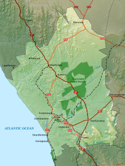
The municipality covers a total area of 12,981 square kilometres (5,012 sq mi) in the northernmost part of the Western Cape province, stretching from the Atlantic Ocean in the west to the mountains of the Bokkeveld Escarpment in the east. The Olifants River flows through the southern part of the municipal area, while to the north lies the hilly area known as the Knersvlakte. The municipality abuts on the Kamiesberg Municipality to the north, the Hantam Municipality to the east and the Cederberg Municipality to the south.
According to the 2011 census the municipality has a population of 67,147 people in 18,835 households. Of this population, 74.7% describe themselves as "Coloured", 14.8% as "White", and 8.5% as "Black African". The first language of 91.8% of the population is Afrikaans, while 3.5% speak Xhosa and 1.8% speak English.[3]
The principal town and seat of the council is Vredendal, which is situated in the valley of the Olifants River and has a population (according to the 2011 census) of 18,170. Other large towns in the municipality are Klawer (pop. 6,234) situated upstream from Vredendal, Lutzville (pop. 5,232) situated downstream from Vredendal, and Vanrhynsdorp (pop. 6,272) to the north-east towards the escarpment. In the Olifants River valley there are also smaller agricultural settlements at Ebenhaeser (pop. 1,305) and Koekenaap (pop. 1,551). South of the mouth of the Olifants River are the coastal villages of Doringbaai (pop. 1,260) and Strandfontein (pop. 431). The villages of Bitterfontein (pop. 986), Kliprand (pop. 205), Nuwerus (pop. 650) and Rietpoort (pop. 970) are situated in the sparsely-populated Knersvlakte in the northern part of the municipality.
Politics
The municipal council consists of fifteen members elected by mixed-member proportional representation. Eight councillors are elected by first-past-the-post voting in eight wards, while the remaining seven are chosen from party lists so that the total number of party representatives is proportional to the number of votes received. In the election of 3 August 2016 the Democratic Alliance (DA) won a majority of seats on the council, defeating an ANC-lead coalition that previously had controlled the municipality. DA later formed a coalition with the United Democrats (UD) after losing its council majority in a by-election.
The following table shows the results of the 2016 election.[4][5][6]
| Party | Votes | Seats | ||||||
|---|---|---|---|---|---|---|---|---|
| Ward | List | Total | % | Ward | List | Total | ||
| Democratic Alliance | 9,833 | 9,782 | 19,615 | 54.7 | 7 | 1 | 8 | |
| ANC | 6,114 | 6,212 | 12,326 | 34.4 | 1 | 4 | 5 | |
| United Democrats | 587 | 559 | 1,146 | 3.2 | 0 | 1 | 1 | |
| Economic Freedom Fighters | 505 | 514 | 1,019 | 2.8 | 0 | 1 | 1 | |
| Patriotic Alliance | 390 | 388 | 778 | 2.2 | 0 | 0 | 0 | |
| New Generation Party | 297 | 197 | 494 | 1.4 | 0 | 0 | 0 | |
| Freedom Front Plus | 184 | 184 | 368 | 1.0 | 0 | 0 | 0 | |
| The Peoples Independent Civic Organisation | 69 | 67 | 136 | 0.4 | 0 | 0 | 0 | |
| Total | 17,979 | 17,903 | 35,882 | 100.0 | 8 | 7 | 15 | |
| Valid votes | 17,979 | 17,903 | 35,882 | 99.3 | ||||
| Spoilt votes | 117 | 122 | 239 | 0.7 | ||||
| Total votes cast | 18,096 | 18,025 | 36,121 | |||||
| Total voter turnout | 18,125 | |||||||
| Registered voters | 30,193 | |||||||
| Turnout percentage | 60.0 | |||||||
The DA subsequently lost one seat to the African National Congress (ANC) in a by-election on 12 December 2018.[7] The council was reconfigured as seen below:
| Party | Ward | PR list | Total | |
|---|---|---|---|---|
| Democratic Alliance | 6 | 1 | 7 | |
| ANC | 2 | 4 | 6 | |
| United Democrats | 0 | 1 | 1 | |
| Economic Freedom Fighters | 0 | 1 | 1 | |
| Total | 8 | 7 | 15 | |
The local council sends two representatives to the council of the West Coast District Municipality: one from the ANC and one from the DA.[8]
References
- "Statistics by place". Statistics South Africa. Retrieved 27 September 2015.
- "Statistics by place". Statistics South Africa. Retrieved 27 September 2015.
- "Matzikama Local Municipality". Census 2011.
- "Results Summary – All Ballots: Matzikama" (PDF). Independent Electoral Commission. Retrieved 27 May 2017.
- "Seat Calculation Detail: Matzikama" (PDF). Independent Electoral Commission. Retrieved 27 May 2017.
- "Voter Turnout Report: Matzikama" (PDF). Electoral Commission. Retrieved 27 May 2017.
- "The ANC ends off the year on a high note in competitive wards". Daily Maverick. 13 December 2018.
- "Political composition of councils February 2017" (PDF). Western Cape Department of Local Government. February 2017. Retrieved 24 May 2017.
External links
Municipalities and communities of West Coast District Municipality, Western Cape | ||
|---|---|---|
District seat: Moorreesburg | ||
| Matzikama | .svg.png.webp) West Coast District within South Africa | |
| Cederberg | ||
| Bergrivier | ||
| Saldanha Bay | ||
| Swartland | ||