Mérillac
Mérillac (Breton: Merelieg) is a commune in the Côtes-d'Armor department of Brittany in northwestern France.
Mérillac
Merelieg | |
|---|---|
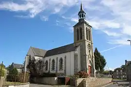 The church of Saint-Pierre, in Mérillac | |
Location of Mérillac 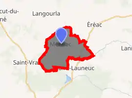
| |
 Mérillac  Mérillac | |
| Coordinates: 48°15′24″N 2°23′35″W | |
| Country | France |
| Region | Brittany |
| Department | Côtes-d'Armor |
| Arrondissement | Saint-Brieuc |
| Canton | Broons |
| Intercommunality | Hardouinais Mené |
| Government | |
| • Mayor (2014–2020) | Claude Delahaye |
| Area 1 | 13.86 km2 (5.35 sq mi) |
| Population (2017-01-01)[1] | 233 |
| • Density | 17/km2 (44/sq mi) |
| Time zone | UTC+01:00 (CET) |
| • Summer (DST) | UTC+02:00 (CEST) |
| INSEE/Postal code | 22148 /22230 |
| Elevation | 108–188 m (354–617 ft) |
| 1 French Land Register data, which excludes lakes, ponds, glaciers > 1 km2 (0.386 sq mi or 247 acres) and river estuaries. | |
Geography
The Meu forms part of the commune's southern border.
The Rance River forms part of the commune's western border, flows east-southeast through the middle of the commune, then forms most of its southeastern border.
Population
| Year | Pop. | ±% |
|---|---|---|
| 1962 | 329 | — |
| 1968 | 385 | +17.0% |
| 1975 | 341 | −11.4% |
| 1982 | 337 | −1.2% |
| 1990 | 267 | −20.8% |
| 1999 | 241 | −9.7% |
| 2008 | 233 | −3.3% |
Inhabitants of Mérillac are called mérillaciens in French.
References
- "Populations légales 2017". INSEE. Retrieved 6 January 2020.
External links
| Wikimedia Commons has media related to Mérillac. |
- Base Mérimée: Search for heritage in the commune, Ministère français de la Culture. (in French)
| Authority control |
|---|
This article is issued from Wikipedia. The text is licensed under Creative Commons - Attribution - Sharealike. Additional terms may apply for the media files.