List of recumbent stone circles
Recumbent stone circles are found in Aberdeenshire in northeast Scotland. Their most striking characteristic is that in the general direction of south-southwest there is a large stone lying on its side with its length lining up with the perimeter of the circle. Thought to have been from the Bronze Age, their unusual design, and the possibility of being associated with astronomical observations, has attracted several surveys starting at the beginning of the 20th century.
_(cropped).jpg.webp)
In 2011 the Royal Commission on the Ancient and Historical Monuments of Scotland published an authoritative book on this type of monument and produced an online gazetteer. Since publication, two other recumbent stone circles have been identified by archaeologists.
Surveys including recumbent stone circles
_(geograph_4407419).jpg.webp)
The particular characteristic of recumbent stone circles is that, as well as being a ring of upright stones (orthostats), they have a large stone lying on its side along the perimeter of the circle towards south to southwest. On both sides are particularly tall orthostats. The recumbent stone and flankers, as they are called, together form the recumbent setting. Around the ring the orthostats get progressively lower in height and more closely spaced until they reach the opposite side from the setting. These stone circles contain a low central ring cairn surrounded by comparatively small kerb stones.[1][2]

Thought to have been built in the Bronze Age, over the millennia many of these circles have become ruinous, being particularly vulnerable in the 18th and 19th centuries due to agricultural improvement, so many stones have fallen or been taken away and, indeed, only about half of the circles show any signs of a cairn without archaeological excavation.[3]
As early as 1527 Hector Boece was writing about the stone circles in Scottorum Historia.[1][4] Until the mid 19th century these circles, when they were noticed at all, were spoken of as being "Druidical Temples" or similar epithets and it was Frederick Coles who was the first person to carry out a systematic survey which he published in an annual series of papers from 1900 to 1907 in the Proceedings of the Society of Antiquaries of Scotland.[5][note 1] Although Coles was careful and cautious in his identifications, he sometimes made misidentifications of circles in a ruinous condition.[6][7] Somewhat similar stone circles were later found in the far southwest of Ireland where they were originally called recumbent stone circles until significant differences led to them becoming called "Cork–Kerry stone circles" and later axial stone circles.[8][9]

As part of their wider interest in northern European stone circles, the northeast Scotland circles attracted Alexander Thom, Aubrey Burl and Clive Ruggles who catalogued them as part of their investigations into whether the recumbent setting could in some way be shown to have an astronomical significance.[note 2][10] Those identified as recumbent stone circles all were found in the traditional counties of Aberdeenshire (historic county) and Kincardineshire (with a very few just over the borders into Angus, and Banffshire).[11] In current terms except for two they are all in the Aberdeenshire council area.[12] In 2011 the Royal Commission on the Ancient and Historical Monuments of Scotland (RCAHMS) published an authoritative book, Welfare (2011), on recumbent stone circles specifically.[13][14] The RCAHMS also issued an online gazetteer giving details of each monument that listed 71 as confirmed being recumbent[15] and another 85 as not belonging in this category.[16][17]
List of circles categorised as recumbent by RCAHMS
| No. [n 1] | Name, parish [n 2] | Condition Stones: S+F/T [n 3] | Code [n 4] | Diameter (metre) [n 5] | Axis [n 6] | Burl refs. [n 7] | Canmore map/ ID Grid ref[n 8] | Lat/ Long [n 9] | |
|---|---|---|---|---|---|---|---|---|---|
| 1 | Aikey Brae, Old Deer[18] | ruin 5+5/11 | wRE | 16.5x15 | 185.5° | Ab90 Ab1 | NJ94NE 4 20571 NJ958470 | .jpg.webp) | 57.51398°N 2.07041°W |
| 2 | Aquhorthies, Banchory-Devenick[19] | good 15+0/18 | WR_ | 25x23.5 | 174° | Ki165 Ki2 [n 10] | NO99NW 1 37186 NO901963 | _(geograph_4551791).jpg.webp) | 57.05801°N 2.16351°W |
| 3 | Ardlair, Kennethmont[20] | ruin 5+3/9 | WRE | 11 | 159° | Ab91 Ab2 | NJ52NE 4 17641 NJ552279 | _(geograph_4712192).jpg.webp) | 57.33978°N 2.74472°W |
| 4 | Ardtannes Cottages, Inverurie[21] | gone 0+0/? | ___ | - | NJ72SE 34 18906 NJ757204 | .jpg.webp) | 57.27369°N 2.40327°W | ||
| 5 | Auchlee, Banchory-Devenick | ruin 25+5/13 | _R_ | 20 | Ki1 | NO89NE 4 37069 NO890968 | _(geograph_4551903).jpg.webp) | 57.06284°N 2.18233°W | |
| 6 | Auchmachar, Old Deer[18] | gone 3+2/9 | wrE | 15 | Ab4 | NJ95SW 11 20746 NJ948502 |  | 57.54226°N 2.08784°W | |
| 7 | Auchmaliddie, New Deer[18] | gone 0+2/? | wr_ | - | Ab5 | NJ84SE 1 19879 NJ881448 | _(geograph_4468345).jpg.webp) | 57.49363°N 2.19932°W | |
| 8 | Balnacraig, Lumphanan[19] | gone 3+2/13or14 | _R_ | 29 | 224° | Ab8 | NJ60SW 5 18024 NJ603035 | _(geograph_4955883)_(cropped).jpg.webp) | 57.12099°N 2.65676°W |
| 9 | Balquhain, Chapel of Garioch[22] | ruin 6+4/14 | WR_ | 21 | 190° | Ab94 Ab9 | NJ72SW 2 18989 NJ735240 | .jpg.webp) | 57.30653°N 2.44147°W |
| 10 | Bankhead, Clatt[20] | gone 0+1/10+ | ___ | 23 | Ab27 | NJ52NW 25 17663 NJ529269 | .png.webp) | 57.33092°N 2.78341°W | |
| 11 | Bellman's Wood, Marnoch[23] | gone 0+2/? | ___ | 6.9[24] | Ba1 | NJ65SW 4 18427 NJ604504 | _(geograph_4743220).jpg.webp) | 57.54208°N 2.66215°W | |
| 12 | Berrybrae, Lonmay[18] | ruin 5+0/10 | WRE | 13x10.7[25] | 231° | Ab95 Ab10 | NK05NW 2 21099 NK027571 |  | 57.60444°N 1.95563°W |
| 13 | Binghill, Peterculter[19] | gone 3+5/10+ | wRe | 11.3 | 187° | Ab11 | NJ80SE 16 19377 NJ855023 | _(geograph_4452923).jpg.webp) | 57.11206°N 2.24069°W |
| 14 | Blue Cairn of Ladieswell, Logie Coldstone | ruin 3+5/10 | _R_ | 23 | 207° | Ab12 | NJ40NW 4 17000 NJ411063 | _(geograph_4951460).jpg.webp) | 57.14407°N 2.97446°W |
| 15 | Braehead, Leslie[20] | gone 1+0/? | _R_ | - | Ab14 | NJ52NE 6 17643 NJ592255 | _(geograph_4729412).jpg.webp) | 57.31877°N 2.67805°W | |
| 16 | Cairn Riv,[26][n 11] Inverkeithny | gone 2+0/? | _R_ | 30+? | Ab20 | NJ64NE 4 18323 NJ674465 | .jpg.webp) | 57.50833°N 2.54504°W | |
| 17 | Cairnton, Forgue | gone 2+0/? | WR_ | - | Ab22 | NJ54SE 1 17855 NJ585446 | _(geograph_4743341).jpg.webp) | 57.49036°N 2.6924°W | |
| 18 | Candle Hill, Insch[20] | ruin 1+7/9or10 | wre | 15.5 | 163.5° | Ab23 | NJ52NE 10 17615 NJ599299 | _(geograph_4452210).jpg.webp) | 57.35844°N 2.66798°W |
| 19 | Castle Fraser, Cluny[22] | good 7+3/10 | WRE | 20.5 | 203° | Ab97 Ab25 | NJ71SW 3 18719 NJ715125 | _(geograph_4834164).jpg.webp) | 57.20266°N 2.47333°W |
| 20 | The Cloch, Benholm | unc. 1+0/? | _R_ | - | Ki6 | NO76NE 1 36304 NO781679 | _(geograph_5176735).jpg.webp) | 56.80247°N 2.35987°W | |
| 21 | Clune Wood, Durris[19] | ruin 7+2/9 | WRE | 17.5x16.7 | 183° | Ki18 [n 12] | NO79SE 2 36696 NO794949 | _(geograph_4492692).jpg.webp) | 57.04517°N 2.34013°W |
| 22 | Colmeallie, Edzell[n 13] | gone 7+6/14 | _rE | 17 | 202.5° | An7 | NO57NE 3 35145 NO565781 | _(geograph_4929022).jpg.webp) | 56.8924°N 2.71479°W |
| 23 | Corrie Cairn, Tullynessle and Forbes | unc. 2+0/? | _R_ | 18.9?[24] | Ab30 | NJ52SE 13 17683 NJ552205 | _(geograph_4712713).jpg.webp) | 57.27312°N 2.74421°W | |
| 24 | Corrstone Wood, Auchindoir and Kearn[20] | gone 1+6/17+ | Wre | 28 | Ab31 | NJ52NW 2 17657 NJ510271 | _(geograph_4711812).jpg.webp) | 57.33188°N 2.81532°W | |
| 25 | Corrydown, Auchterless[26] | ruin 1+6/? | wR_ | 23 | 186° | Ab32 | NJ74SW 11 19197 NJ706444 | _(geograph_4423393).jpg.webp) | 57.48942°N 2.49071°W |
| 26 | Cothiemuir Wood, Keig[22] | ruin 7+1/13- | WRE | 20 | 200° | Ab98 Ab34 | NJ61NW 1 18055 NJ617198 | _(geograph_4729704).jpg.webp) | 57.26725°N 2.63648°W |
| 27 | Druidstone, Premnay | ruin 5+6/? | w_e | 14.5 | 199° | Ab42 | NJ62SW 4 18213 NJ615221 | _(geograph_4729654).jpg.webp) | 57.2887°N 2.63984°W |
| 28 | Dunnideer, Insch[20] | gone 3+0/? | WRE | - | Ab44 | NJ62NW 4 18161 NJ608284 | 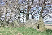 | 57.34478°N 2.65194°W | |
| 29 | Easter Aquhorthies, Inverurie[n 14] | good 12+0/12 | WRE | 20x18.5 | 195.5° | Ab102 Ab46 | NJ72SW 12 18981 NJ732207 | .jpg.webp) | 57.27696°N 2.44559°W |
| 30 | Eslie the Greater, Banchory-Ternan[19] | ruin 9+0/12 | WRE | 24 | 176° | Ki169 Ki11 | NO79SW 2 36714 NO717915 | _(geograph_4446221).jpg.webp) | 57.01458°N 2.46748°W |
| 31 | Frendraught, Forgue[27] | gone 1+7/? | _R_ | 22x20 | Ab50 | NJ64SW 6 18370 NJ610428 | _(geograph_4743350).jpg.webp) | 57.47423°N 2.65041°W | |
| 32 | Gaval, Old Deer[18] | gone 1+0/? | ___ | - | Ab53 | NJ95SE 3 20734 NJ980515 | _(geograph_4468812).jpg.webp) | 57.5536°N 2.03422°W | |
| 33 | The Gray Stone of Clochforbie, King Edward[18] | gone 0+1/? | _r_ | - | Ab28 | NJ75NE 1 19227 NJ796586 | _(geograph_4467826).jpg.webp) | 57.61719°N 2.34178°W | |
| 34 | Hatton of Ardoyne, Oyne[22] | good 5+4/13+ | _RE | 27x25 | 219.5° | Ab59 | NJ62NE 7 18125 NJ659267 | _(geograph_4452825).jpg.webp) | 57.3301°N 2.56665°W |
| 35 | Hill of Fiddes, Foveran[20] | gone 2+0/10 | WR_ | 14 | Ab61 | NJ92SW 1 20401 NJ935243 | _(geograph_5014018).jpg.webp) | 57.30941°N 2.10952°W | |
| 36 | Hill of Milleath, Cairnie[23] | gone 0+0/?[n 15] | ___ | 23.7 | Ab54 [n 16] | NJ44SE 9 17326 NJ467429 | .jpg.webp) | 57.47359°N 2.88884°W | |
| 37 | Inschfield, Insch[20] | gone 1+2/? | _rE | 23.5 | Ab67 | NJ62NW 6 18167 NJ623293 |  | 57.35299°N 2.62766°W | |
| 38 | Kirkton of Bourtie, Bourtie[20] | ruin 5+0/10or11 | _RE | 22 | Ab105 Ab68 | NJ8ZSW 2 19708 NJ800248 |  | 57.31405°N 2.33216°W | |
| 39 | Loanend, Premnay[22] | gone 2+0/? | _R_ | 25 | Ab70 | NJ62SW 1 18190 NJ604242 | _(geograph_4729461).jpg.webp) | 57.30676°N 2.65741°W | |
| 40 | Loanhead of Daviot, Daviot[20] | good 11+0/11 | WRE | 21 | 200° | Ab106 Ab71 | NJ72NW 1 18789 NJ747288 | 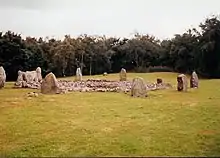 | 57.34945°N 2.42088°W |
| 41 | Loudon Wood, Old Deer[28] | ruin 4+3/10or11 | WRe | 19.6x17.5 | 194° | Ab108 Ab74 | NJ94NE 1 20538 NJ960497 | _(geograph_4468451).jpg.webp) | 57.53769°N 2.06695°W |
| 42 | Mains of Hatton, Auchterless[26] | ruin 2+7/12+ | _R_ | 23x21 | 165° | Ab75 | NJ64SE 6 18357 NJ699425 | _(geograph_4743380).jpg.webp) | 57.47212°N 2.50299°W |
| 43 | Midmar Kirk, Midmar | OK 8+0/11 | WRE | 17 | 231° | Ab109 Ab78 | NJ60NE 3 18001 NJ699064 |  | 57.14831°N 2.49842°W |
| 44 | Millplough, Arbuthnott[26] | gone 1+0/? | _R_ | 20- | Ki15 | NO87NW 6 36819 NO819754 | _(geograph_5176813).jpg.webp) | 56.87001°N 2.29835°W | |
| 45 | Montgoldrum, The Camp, Arbuthnott[26] | gone 3+2/? | _r_ | 23 | 179° | Ki5 [n 17] | NO87NW 5 36818 NO816772 | _(geograph_5176948).jpg.webp) | 56.88581°N 2.30258°W |
| 46 | Nether Dumeath, Glass[23] | gone 2+4/12 | ___ | 11 | Ab85 | NJ43NW 7 17280 NJ425378 | .jpg.webp) | 57.42744°N 2.95866°W | |
| 47 | Netherton of Logie, Crimond[18] | ruin 11+17/15? | WRE | 17 | 185° | Ab86 | NK05NW 3 21100 NK043572 | _(geograph_4469161).jpg.webp) | 57.60497°N 1.92902°W |
| 48 | New Craig, Daviot[20] | gone 4+1/? | WRE | 22+ | Ab87 | NJ72NW 3 18811 NJ745296 |  | 57.35671°N 2.42462°W | |
| 49 | The Nine Stanes, Garrol, Banchory-Ternan[19] | ruin 9+1/11 | Wre | 18.5x15.5 | 157.5° | Ki171 Ki13 [n 18] | NO79SW 8 36748 NO723912 | _(geograph_4444540).jpg.webp) | 57.01129°N 2.45723°W |
| 50 | North Strone, Alford[20] | good 5+13/18 | wrE | 18.5 | 180° | Ab110 Ab88 | NJ51SE 2 17588 NJ584138 | 57.21388°N 2.6897°W | |
| 51 | Old Keig, Keig | ruin 4+4/? | WRE | 27 | 212.5° | Ab111 Ab89 | NJ51NE 2 17530 NJ596193 | _(geograph_4729775).jpg.webp) | 57.26339°N 2.67057°W |
| 52 | Old Kirk of Tough, Cluny[20] | ruin 2+0/11? | ___ | 25? | Ab6 | NJ60NW 1 18006 NJ625092 | _(geograph_4955986).jpg.webp) | 57.17282°N 2.62179°W | |
| 53 | Old Rayne, Rayne[20] | ruin 1+7/10+ | ___ | 26.5? | 195° | Ab112 Ab90 | NJ62NE 1 18081 NJ679279 | _(geograph_4440325).jpg.webp) | 57.34121°N 2.53359°W |
| 54 | Pitglassie, Auchterless[26] | ruin 1+1/12- | _R_ | 18 | Ab91 | NJ64SE 8 18359 NJ686434 | _(geograph_4423622).jpg.webp) | 57.48048°N 2.52495°W | |
| 55 | Potterton, Belhelvie[27] | gone 1+2/? | wRe | - | Ab92 | NJ91NE 7 20294 NJ952163 | .jpg.webp) | 57.23793°N 2.07965°W | |
| 56 | The Ringing Stone, Cairnie[20] | gone 1+5/? | _R_ | 18.3[24] | 188.5° | Ab92 Ab3 [n 19] | NJ54NW 12 17827 NJ531454 | _(geograph_4742653).jpg.webp) | 57.49683°N 2.78312°W |
| 57 | Rothiemay, Rothiemay[26][n 20] | ruin 5+0/12or14 | _R_ | 28 | 216.5° | Ba134 Ba13 | NJ54NE 6 20294 NJ550487 | .jpg.webp) | 57.5264°N 2.7517°W |
| 58 | St Brandan's Stanes, Boyndie[23] | gone 2+3/? | W_E | - | Ba14 | NJ66SW 1 18495 NJ607610 |  | 57.63767°N 2.65903°W | |
| 59 | South Fornet, Skene[20] | ruin 2+6/? | W_E | 26.8[24] | Ab100 | NJ71SE 1 18687 NJ782109 | _(geograph_4604088).jpg.webp) | 57.18902°N 2.36081°W | |
| 60 | South Ley Lodge, Kintore[20] | gone 3+0/? | WRE | 16.5? or 29.6? | Ab101 | NJ71SE 3 18705 NJ766132 | _(geograph_4834055).jpg.webp) | 57.20942°N 2.38783°W | |
| 61 | Stonehead, Insch | ruin 3+0/? | WRE | 19x16?[24] | Ab103 | NJ62NW 5 18166 NJ601286 | _(geograph_4452270).jpg.webp) | 57.34696°N 2.66461°W | |
| 62 | Strichen House, Strichen[18][n 21] | OK 9+1/10 | WRE | 15.4x12.8 | 161° | Ab116 Ab105 | NJ95SW 2 20754 NJ936544 | _(geograph_4468664).jpg.webp) | 57.58024°N 2.10749°W |
| 63 | Sunhoney, Midmar[28] | good 11+1/12 | WrE | 25 | 231° | Ab117 Ab106 | NJ70NW 55 18543 NJ715057 | 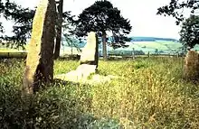 | 57.14132°N 2.47106°W |
| 64 | Tillyfourie, Monymusk[22] | ruin 4+9/13 | WRe | 20 | 203° | Ab120 [n 22] | NJ61SW 3 18074 NJ643135 |  | 57.21087°N 2.59247°W |
| 65 | Tilquhillie, Banchory-Ternan[29] | gone 1+1/? | ___ | - | Ki19 | NO79SW 10 36704 NO725940 | _(geograph_4844789).jpg.webp) | 57.03627°N 2.45473°W | |
| 66 | Tomnagorn, Midmar[19] | ruin 7+5/12 | WRE | 21 | 202.5° | Ab118 Ab108 | NJ60NE 1 17999 NJ651077 | _(geograph_4447581).jpg.webp) | 57.15928°N 2.57792°W |
| 67 | Tomnaverie, Coull[28] | OK[n 23] 11+0/13 | wre[n 24] | 17 | 235.5° | Ab119 Ab109 | NJ40SE 1 17006 NJ486034 |  | 57.11947°N 2.84962°W |
| 68 | Tyrebagger, Dyce[19] | good 10+1/11 | WRE | 18.5 | 178.5° | Ab101 Ab45 [n 25] | NJ40SE 11 19513 NJ859132 | _(geograph_4844309).jpg.webp) | 57.20944°N 2.23421°W |
| 69 | Wantonwells, Insch[20] | gone 1+1/? | _Re | - | Ab115 | NJ62NW 2 18139 NJ618272 | _(geograph_4452798).jpg.webp) | 57.33454°N 2.63499°W | |
| 70 | Wester Echt, Echt[19] | ruin 3+0/? | W__ | 23 | Ab118 | NJ70NW 2 18534 NJ738083 | _(geograph_4493708).jpg.webp) | 57.16516°N 2.43399°W | |
| 71 | Yonder Bognie, Forgue[26] | ruin 6+3/12- | WRe | 22x18 | 182.5° | Ab122 Ab122 | NJ64NW 15 18335 NJ600457 | _(geograph_4743288).jpg.webp) | 57.50037°N 2.66807°W |
Recently classified recumbent stone circles

In 2013 a site at Hillhead was excavated and found to be a recumbent stone circle. The site had been noticed in 1998 but was thought to have been the location of the remains of a roundhouse. The excavation uncovered the sockets for two flankers and a depression in the ground where the recumbent probably lay.[31][32] Nether Coullie stone circle was listed in the 2011 RCAHS gazetteer as not being a recumbent stone circle but following careful inspection of archive records and another site inspection it was reclassified in 2015.[33][34] Other stone circles investigated recently, but which have found to be modern, include Mill of Birkenbower and Holmhead.[35][36]
| No. | Name, parish [n 2] | Condition Stones: S+F/T [n 3] | Code [n 4] | Diameter (metre) [n 5] | Axis [n 6] | Burl refs. [n 7] | Canmore map/ ID Grid ref[n 8] | Lat/ Long [n 9] | |
|---|---|---|---|---|---|---|---|---|---|
| - | Hillhead,[31] Tarland | gone 0+1/?[n 26] | ___[n 26] | 26[32] | 237°[32] | - | NJ50NW 61 138717 NJ507071 |  | 57.15248°N 2.81618°W |
| Ap1, 65[n 27] | Nether Coullie,[n 27] Monymusk[22] | gone 0+1/?[n 28] | ___[n 28] | 24[24] | Ab84 | NJ71NW 11 18657 NJ709156 | _(geograph_5501900).jpg.webp) | 57.23056°N 2.482317°W |
Notes for table
- Numbers are those of Welfare (2011a).
- From Welfare (2011a). All are in the current Aberdeenshire council area except the two otherwise noted.
- Condition: condition from Burl (2000, Gazetteer). Burl classifies the sites as follows 1 (good) = Good, worth visiting; 2 (OK) = Good but restored; 3 (ruin) = Ruined but recognisable; 4 (gone) = Destroyed or unrecognisable; 5 (unc.) = Uncertain.
S+F/T: Number of stones Standing + number Fallen or mere stumps / Total number originally. Details from Welfare (2011a, Appendix 3) for standing and fallen and Welfare (2011a, Individual site entry in gazetteer) for original total. - Code for status of recumbent setting. W/w refers to west flanker, R/r to recumbent and E/e to east flanker. Upper case means standing, lower case means fallen, — means missing. Details from Welfare (2011a, Gazetteer entry for each circle) unless otherwise noted.
- Diameters from Welfare (2011a) except where otherwise noted. Maximum and minimum given when oval.
- Azimuth of the axis from centre of circle and over centre of recumbent stone from Ruggles (1984, Table 2). South is 180°, southwest is 225°.
- Reference numbers are those of Burl (1995) and later edition and Burl (2000). In both books the entries are divided by traditional county (Ab=Aberdeenshire, An=Angus, Ba=Banffshire, Ki=Kincardinshire).
- Canmore site reference and OS grid reference from Welfare (2011a), grid references truncated from 8 to 6 figures.
- Converted from 8-figure OS grid reference.
- Burl calls Aquhorthies "Auchquhorthies".
- Cairn Riv also called Carlin stone.
- Burl calls Clune Wood "Raes o’Clune".
- Colmeallie, Edzell is in the traditional county and council area of Angus
- Coles calls Easter Aquhorthies "Auchquhorthies, Manar."[22]
- In 1905 Coles found the circle had been completely destroyed in about 1875.[23]
- Burl calls Milleath "Gingomyres"
- Burl calls Montgoldrum "The Camp".
- Burl calls Nine Stanes "Garrol Wood".
- Burl calls Ringing Stone "Arnhill".
- Rothiemay is in the council area of Moray.
- Strichen House has been wholly reconstructed.
- Burl calls Tillyfourie "Whitehill".
- Status was "ruin" and stones 5+5/13 before 1999 reconstruction of Bradley (2005).
- According to Ruggles (1984, Table 1). WRE after 1999 reconstruction.[30]
- Burl calls Tyrebagger "Dyce".
- Only one fallen orthostat exists.[32]
- Included in Welfare (2011a) in Appendix 1, number 65, as not meeting the requirements of an RSC.[33]
- Only one fallen orthostat exists.[33]
Notes for introduction
- Coles' papers involving recumbent stone circles are listed below. See Frederick Coles for his whole series of PSAS papers including his 1910 summary table.
- In particular Ruggles (1984), Ruggles & Burl (1985), Burl (1995) and Burl (2000).
References
Citations
- Welfare (2011), p. 1.
- Burl (2000), pp. 215–218.
- Welfare (2011), pp. 31–33, 67, 73, 162–167.
- Burl (2000), p. 226.
- Welfare (2011), pp. 3–8.
- Burl (2000), p. 219.
- Welfare (2011), p. p=16.
- Burl (2000), pp. 41–42.
- Ó Nualláin (1975), pp. 84–85.
- Welfare (2011), pp. 195–196.
- Burl (2000), pp. 419–435.
- Welfare (2011a), Gazetteer, pp. 273–490 (pp. 11–226 in pdf file).
- Noble (2015), pp. 584–585.
- Welfare (2011), pp. 1–29.
- Welfare (2011a), Appendix 1, pp. 271–490 (p. 7–226 in pdf file).
- Welfare (2011a), Appendix 1, pp. 492–550 (pp. 228–286 in pdf file).
- Welfare (2011), p. 19–20.
- Coles (1904).
- Coles (1900).
- Coles (1902).
- Davidson (1878), p. 4.
- Coles (1901).
- Coles (1906).
- Burl (2000).
- Burl (1995).
- Coles (1903).
- Ritchie (1917).
- Coles (1905).
- Ritchie (1919).
- Bradley (2005).
- Bradley & Clarke (2016), pp. 7–26.
- Historic Environment Scotland. "Hillhead (138717)". Canmore. Retrieved 18 March 2020.
- Historic Environment Scotland. "Nether Coullie (18657)". Canmore. Retrieved 18 March 2020.
- Welfare (2011), Individual site entry in gazetteer.
- Historic Environment Scotland. "Mill Of Birkenbower (304497)". Canmore. Retrieved 18 March 2020.
- Historic Environment Scotland. "Holmhead (363542)". Canmore. Retrieved 18 March 2020.
Works cited and further reading
- Bradley, Richard; Phillips, Tim; Arrowsmith, Sharon; Ball, Chris (2005). The Moon and the Bonfire: an investigation of three stone circles in north-east Scotland. Society of Antiquaries of Scotland. ISBN 0903903334. – available online
- Bradley, Richard; Clarke, Amanda (30 September 2016). "Excavations at Hillhead, Tarland, Aberdeenshire: a recumbent stone circle and its history". In Nimura, Courtney; Bradley, Richard (eds.). The Use and reuse of stone circles: Fieldwork at five Scottish monuments and its implications. Oxbow Books. pp. 7–26. ISBN 978-1-78570-246-4.
- Burl, Aubrey (1995). A Guide to the Stone Circles of Britain, Ireland, and Brittany. Yale University Press. ISBN 0-300-06331-8. – the 2005 edition sems the same but with an additional appendix
- Burl, Aubrey (2000). The Stone Circles of Britain, Ireland, and Brittany. Yale University Press. ISBN 0-300-08347-5.
- Coles, Frederick (1900) [First published 30-11-1900]. "Report on Stone Circles in Kincardineshire (North), and part of Aberdeenshire, with measured Plans and Drawings". Proceedings of the Society of Antiquaries of Scotland. 34 (1899): 139–198.
- Coles, Frederick (1901) [First published 30-11-1901]. "Report on the Stone Circles of the North-East of Scotland, Inverurie District, with Measured Plans and Drawings". Proceedings of the Society of Antiquaries of Scotland. 35 (1900): 187–248.
- Coles, Frederick (1902) [First published 30-11-1902]. "Report on Stone Circles in Aberdeenshire (Inverurie, Eastern Parishes, and Insch Districts), with measured Plans and Drawings". Proceedings of the Society of Antiquaries of Scotland. 36 (1901): 488–581.
- Coles, Frederick (1903) [First published 30-11-1903]. "Report on the Stone Circles of North-Eastern Scotland, chiefly in Auchterless and Forgue, with measured Plans and Drawings". Proceedings of the Society of Antiquaries of Scotland. 37 (1902): 82–142.
- Coles, Frederick (1904) [First published 30-11-1904]. "Report on Stone Circles of the North-East of Scotland - the Buchan District - with measured Plans and Drawings". Proceedings of the Society of Antiquaries of Scotland. 38 (1903): 256–305.
- Coles, Frederick (1905) [First published 30-11-1905]. "Record of (I) the Excavation of two Stone Circles in Kincardineshire: (1) in Garrol Wood, Durris; (2) in Glassel Wood, Banchory-Ternan; and (II) Report on Stone Circles in Aberdeenshire, with measured Plans and Drawings and (ii.) Report on stone circles in Aberdeenshire, with measured plans and drawings". Proceedings of the Society of Antiquaries of Scotland. 39 (1904): 190–218.
- Coles, Frederick (1906) [First published 30-11-1906]. "Report on Stone Circles surveyed in the North-East of Scotland, chiefly in Banffshire, with measured Plans and Drawings". Proceedings of the Society of Antiquaries of Scotland. 40 (1905): 164–206.
- Davidson, John (1878). Inverurie and the earldom of the Garioch; a topographical and historical account of the Garioch from the earliest times to the revolution settlement. Edinburgh: David Douglas.
- Noble, Gordon (2 January 2015). "Adam Welfare, edited by Stratford Halliday. Great crowns of stone: the recumbent stone circles of Scotland". Antiquity. 86 (332): 584–586. doi:10.1017/S0003598X00063109.
- Ó Nualláin, Seán (1975). "The Stone Circle Complex of Cork and Kerry". Journal of the Royal Society of Antiquaries of Ireland. 105: 83–131. JSTOR 25508668.
- Ritchie, James (1917) [First published 30-11-1917]. "Notes on some Stone Circles in Central Aberdeenshire". Proceedings of the Society of Antiquaries of Scotland. 51 (1916): 30–47. ISSN 2056-743X.
- Ritchie, James (1919) [First published 30-11-1919]. "Notes on some Stone Circles in the South of Aberdeenshire and North of Kincardineshire". Proceedings of the Society of Antiquaries of Scotland. 53 (1918). ISSN 2056-743X.
- Ruggles, C. L. N. (1984) [First published 30-11-1916]. "A New Study of the Aberdeenshire Recumbent Stone Circles, 1: Site Data". Journal for the History of Astronomy, Archaeoastronomy Supplement. 15: S55–S76. Bibcode:1984JHAS...15...55R. ISSN 0142-7253.
- Ruggles, C. L. N.; Burl, H. A. W. (1985). "A New Study of the Aberdeenshire Recumbent Stone Circles, 2: Interpretation". Journal for the History of Astronomy, Archaeoastronomy Supplement. 16: S25–S60. Bibcode:1985JHAS...16...25R. ISSN 0142-7253.
- Welfare, Adam (2011). Halliday, Stratford (ed.). Great Crowns of Stone: The Recumbent Stone Circles of Scotland. Edinburgh: RCAHMS. ISBN 978-1-902419-55-8.
- Welfare, Adam (2011a). Halliday, Stratford (ed.). Great Crowns of Stone: The Recumbent Stone Circles of Scotland Gazetteer and Appendices (PDF). RCAHMS. Archived (PDF) from the original on 11 December 2019. – only published online