List of ecoregions in Minnesota
The list of ecoregions in Minnesota provides an overview to the ecoregions (see also, ecosystem) in the U.S. state of Minnesota,[1] as defined separately by the Environmental Protection Agency/Commission for Environmental Cooperation, the Minnesota Department of Natural Resources, and the World Wildlife Fund.

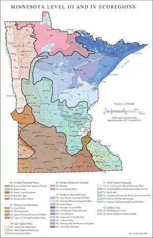
Minnesota ecoregions map prepared by the United States Environmental Protection Agency
Environmental Protection Agency/Commission for Environmental Cooperation[2][3]
| Level I | Level III | Level IV |
|---|---|---|
| 9 – Great Plains 9.2 – Temperate Prairies |
46 – Northern Glaciated Plains | 46e – Tewaukon Big Stone Stagnation Moraine 46k – Prairie Coteau 46l – Prairie Coteau Escarpment 46m – Big Sioux Basin |
| 47 – Western Corn Belt Plains | 47a – Loess Prairies 47b – Des Moines Lobe 47c – Eastern Iowa and Minnesota Drift Plains 47g – Lower St Crois and Vermillion Valleys | |
| 48 – Lake Agassiz Plain | 48a – Glacial Lake Agassiz Basin 48b – Beach Ridges and Sand Deltas 48d – Lake Agassiz Plains | |
| 5 – Northern Forests 5.2 – Mixed Wood Shield |
49 – Northern Minnesota Wetlands | 49a – Peatlands 49b – Forested Lake Plains |
| 50 – Northern Lakes and Forests | 50a – Lake Superior Lacustrine Clay Plain 50b – Minnesota/Wisconsin Upland Till Plain 50m – Mesabi Range 50n – Boundary Lakes and Hills 50o – Glacial Lakes Upham and Aitken 50p – Toimi Drumlins 50q – Itasca and St Louis Moraines 50r – Chippewa Plains 50s – Nashwauk/Marcell Moraines and Uplands 50t – North Shore Highlands Subsection | |
| 8 – Eastern Temperate Forest 8.1 – Mixed Wood Plains |
51 – North Central Hardwood Forests | 51a – St. Croix Outwash Plain and Stagnation Plains 51h – Anoka Sand Plain and Mississippi Valley 51i – Big Woods 51j – Alexandria Moraines and Detroit Lakes Outwash Plains 51k – McGraw Till Plain and Drumlins 51l – Wadena/Todd Drumlins and Osakis Till Plain |
| 52 – Driftless Area | 52b – Blufflands and Coulees 52c – Rochester/Paleozoic Plateau Upland |
Minnesota Department of Natural Resources
The Minnesota Department of Natural Resources divides the state of Minnesota into regions based on the agency's Ecological Classification System (ECS), which follows the guidelines set forth by the National Hierarchical Framework of Ecological Units. [4]
| Provinces | Sections | Subsections |
|---|---|---|
| 212 – Laurentian Mixed Forest Province | 212J – Southern Superior Uplands | 212Ja – Glacial Lake Superior Plain 212Jd – St. Croix Moraine |
| 212K – Western Superior Uplands | 212Kb – Mille Lacs Uplands | |
| 212L – Northern Superior Uplands | 212La – Border Lakes 212Lb – North Shore Highlands 212Lc – Nashwauk Uplands 212Ld – Toimi Uplands 212Le – Laurentian Uplands | |
| 212M – Northern Minnesota and Ontario Peatlands | 212Ma – Littlefork-Vermillion Uplands 212Mb – Agassiz Lowlands | |
| 212N – Northern Minnesota Drift and Lake Plains | 212Na – Chippewa Plains 212Nb – St. Louis Moraines 212Nc – Pine Moraines and Outwash Plains 212Nd – Tamarack Lowlands | |
| 222 – Eastern Broadleaf Forest Province | 222L – Paleozoic Plateau | 222Lc – The Blufflands 222Lf – Rochester Plateau |
| 222M – Minnesota and Northeast Iowa Morainal | 222Ma – Hardwood Hills 222Mb – Big Woods 222Mc – Anoka Sand Plain 222Md – St. Paul-Baldwin Plains 222Me – Oak Savanna | |
| 223 – Tallgrass Aspen Parkland Province | 223N – Lake Agassiz, Aspen Parklands | 223Na – Aspen Parklands |
| 251 –Prairie Parkland Province | 251A – Red River Valley | 251Aa – Red River Prairie |
| 251B – North Central Glaciated Plains | 251Ba – Minnesota River Prairie 251Bb – Coteau Moraines 251Bc – Inner Coteau |
World Wildlife Fund
- Canadian aspen forests and parklands
- Central tall grasslands (consisting of parts of 251B (North Central Glaciated Plains) and 222M – Minnesota and Northeast Iowa Morainal) along with parts of 251C (Central Dissected Till plains) which are not in Minnesota.
- Northern tall grasslands
- Western Great Lakes forests
- Upper Midwest forest-savanna transition
References
- "Interactive Map of Minnesota Level 4 Ecoregions". Retrieved 2010-11-17.
- "Ecological Regions of North America" (PDF). Commission for Environmental Cooperation. 26 May 2006. Archived from the original (pdf) on 25 May 2017. Retrieved 26 March 2010.
- "Minnesota Level III and IV Ecoregions" (pdf). United States Environmental Protection Agency. 11 May 2007. Retrieved 26 March 2010.
- "Ecological Land Classification Hierarchy". Ecological Classification System. Minnesota Department of Natural Resources. 2010. Retrieved 2010-08-11.
This article is issued from Wikipedia. The text is licensed under Creative Commons - Attribution - Sharealike. Additional terms may apply for the media files.