List of covered bridges in Iowa
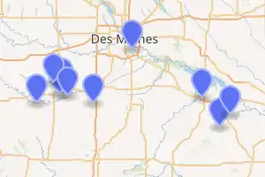
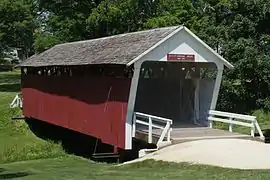
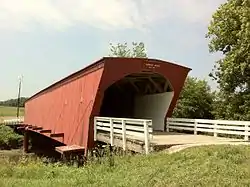
Below is a list of covered bridges in Iowa. There are nine authentic covered bridges in the U.S. state of Iowa, though two halves of one bridge reside in different locations.[1] Six of them are historic. A covered bridge is considered authentic not due to its age, but by its construction. An authentic bridge is constructed using trusses rather than other methods such as stringers, a popular choice for non-authentic covered bridges.

List
| Name | Image | County | Location | Built | Length | Crosses | Ownership | Truss | Notes |
|---|---|---|---|---|---|---|---|---|---|
| Cedar Covered Bridge[2] |  |
Madison | Winterset 41°21′57″N 93°59′27″W |
1883, rebuilt 2004, rebuilt 2019 | Cedar Creek | Also called Casper Covered Bridge; first two bridges were destroyed by arson[3] | |||
| Cutler–Donahoe Bridge[4] |  |
Madison | Winterset 41°19′52″N 94°0′31″W |
1871, 1970 | 79 feet (24 m) | Ditch | City of Winterset | Town | |
| Hammond Bridge[4] |  |
Marion | Hamilton 41°10′39″N 93°0′50″W |
1894 | 80 feet (24 m) | North Cedar Creek | County of Marion | Howe | |
| Hogback Covered Bridge[4] |  |
Madison | Winterset 41°23′9″N 94°3′0″W |
1884 | 106 feet (32 m) | North River | County of Madison | Town | |
| Holliwell Covered Bridge[4] |  |
Madison | Winterset 41°19′21″N 93°57′33″W |
1880 | 113 feet (34 m) | Middle River | County of Madison | Town | |
| Imes Covered Bridge[4] |  |
Madison | St. Charles 41°17′18″N 93°47′56″W |
1870, 1887, 1977 | 81 feet (25 m) | Brook | County of Madison | Town | Also called King Bridge |
| Marysville Covered Bridge[2] | Marion | Knoxville 41°18′59″N 93°7′33″W |
1870, moved 1970 | 41 feet (12 m) | Ravine | Town | Split from Wilcox Game Preserve Bridge in 1970 | ||
| Owens Covered Bridge[2] | Polk | Allen 41°32′25″N 93°33′35″W |
1866 | 100 feet (30 m) | Yeader Creek | Howe | |||
| Roseman Covered Bridge[4] |  |
Madison | Winterset 41°17′31″N 94°9′5″W |
1883 | 107 feet (33 m) | Middle River | County of Madison | Town | Also called Oak Grove Bridge |
| Wilcox Game Preserve Covered Bridge[2] | Marion | Liberty 41°14′9″N 92°57′6″W |
1870, moved 1970 | 40 feet (12 m) | Ravine | Town | Split from Marysville Bridge in 1970 |
See also
References
- Terry E. Miller; Ronald G. Knapp; A. Chester Ong (2013). America's Covered Bridges (Kindle ed.). North Clarendon, Vermont: Tuttle Publishing. pp. 236–237. ISBN 978-1-4629-1420-3.
- Wright, David W. (2009). World Guide to Covered Bridges (2009 ed.). Concord, New Hampshire: National Society for Preservation of Covered Bridges. pp. 31–33. ISBN 978-0-692-00617-7.
- "Cedar Covered Bridge, Winterset, Iowa". www.cedarcoveredbridge.com. Retrieved 9 May 2020.
- "National Register Information System". National Register of Historic Places. National Park Service. July 9, 2010.
External links
| Wikimedia Commons has media related to Covered bridges in Iowa. |
- National Society for the Preservation of Covered Bridges
- Only in Your State article about the state's covered bridges
This article is issued from Wikipedia. The text is licensed under Creative Commons - Attribution - Sharealike. Additional terms may apply for the media files.