List of airports in Guadeloupe
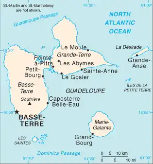
This is a list of airports in Guadeloupe. Guadeloupe is an archipelago located in the eastern Caribbean Sea. It is an overseas department of France comprising five main islands: Basse-Terre Island, Grande-Terre, La Désirade, Les Saintes and Marie-Galante. CAO location identifiers are linked to each airport's Aeronautical Information Publication (AIP), which are available online in Portable Document Format (PDF) from the French Service d'information aéronautique (SIA).
| Commune | Island | ICAO | IATA | Airport name | Usage | Coordinates |
|---|---|---|---|---|---|---|
| Baillif | Basse-Terre | TFFB | BBR[1] | Baillif Airport | Restricted | 16°00′38″N 061°44′32″W |
| Grande-Anse | La Désirade | TFFA | DSD[2] | La Désirade Airport (or Grande-Anse Airport) | Restricted | 16°17′49″N 061°05′04″W |
| Grand-Bourg | Marie-Galante | TFFM | GBJ[3] | Marie-Galante Airport (or Les Bases Airport) | Public | 15°52′07″N 061°16′20″W |
| Pointe-à-Pitre | Grande-Terre | TFFR | PTP[4] | Pointe-à-Pitre Airport (or Le Raizet Airport) | Public | 16°15′51″N 061°31′33″W |
| Saint-François | Grande-Terre | TFFC | SFC[5] | Saint-François Airport | Public | 16°15′28″N 061°15′45″W |
| Terre-de-Haut | Terre-de-Haut (Les Saintes) | TFFS | LSS[6] | Les Saintes Airport (or Terre-de-Haut Airport) | Restricted | 15°51′52″N 061°34′50″W |

The islands of Guadeloupe.
See also
- List of airports by ICAO code: T#Guadeloupe
- Wikipedia: Airline destination lists: North America#Guadeloupe (France)
- Transport in Guadeloupe
- List of airports in France
References
- Airport information for BBR at Great Circle Mapper. Source: DAFIF (effective October 2006).
Accident history for BBR at Aviation Safety Network - Airport information for DSD at Great Circle Mapper. Source: DAFIF (effective October 2006).
Accident history for DSD at Aviation Safety Network - Airport information for GBJ at Great Circle Mapper. Source: DAFIF (effective October 2006).
Accident history for GBJ at Aviation Safety Network - Airport information for PTP at Great Circle Mapper. Source: DAFIF (effective October 2006).
Accident history for PTP at Aviation Safety Network - Airport information for SFC at Great Circle Mapper. Source: DAFIF (effective October 2006).
Accident history for SFC at Aviation Safety Network - Airport information for LSS at Great Circle Mapper. Source: DAFIF (effective October 2006).
Accident history for LSS at Aviation Safety Network
External links
- Aeronautical Information Service / Service d'information aéronautique (SIA), Aeronautical Information Publications (AIP)
- Union des Aéroports Français (in French)
- Great Circle Mapper: Guadeloupe
- World Aero Data: Guadeloupe
This article is issued from Wikipedia. The text is licensed under Creative Commons - Attribution - Sharealike. Additional terms may apply for the media files.