Lalakhan, Santa Maria
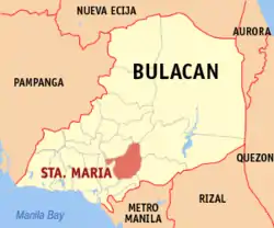
Lalakhan (PSGC: 031423010) is one of the twenty-four barangays comprising the municipality of Santa Maria, Bulacan, in the Philippines. It is bordered by Barangay Bagbaguin on the south, Poblacion on the east, Sta. Clara on the north and Barangay Tambubong in Bocaue on the west.
Barangay Lalakhan, Sta. Maria, Bulacan | |
|---|---|
Barangay | |
 | |
| Coordinates: 14°49.10′N 120°57.38′E | |
| Country | Philippines |
| Region | Central Luzon |
| Province | Bulacan |
| Municipality | Santa Maria |
| Government | |
| • Type | Barangay |
| • Barangay Captain | Romulo R. Ramirez |
| Elevation | 42 m (138 ft) |
| Time zone | GMT (UTC+8) |
| Zip Code | 3022 |
| Area code(s) | 44 |
Geography
Area and Location
Lalakhan is the smallest barangay in Santa Maria with a land area of 33.54 hectares or 0.3354 km2. It is located on the south-west portion of Sta. Maria and thirty-three kilometers north from Manila.
Climate
The prevailing climatic conditions in the barangay are categorized into two (2) types: dry and wet season.
The annual mean temperature in the area is 27℃. The warmest month is May with a mean temperature of 29.9℃ while the coldest is January at 25.2℃.
The mean annual relative humidity in the Barangay is 77% which is not high. The mean monthly relative humidity is lowest in March at 64% and highest in September at 84%
Demographics
As of 2007 census, Lalakhan has a population of 2,116 people with a density of 6,308.88 person per km2. The projected population of the barangay by 2010 is 2,225 with a growth rate of 1.7%.
Population Projection
This is the projected population of the barangay by the next few years:
- 2008 - 2,151
- 2009 - 2,188
- 2010 - 2,225
- 2011 - 2,263
- 2012 - 2,302
- 2013 - 2,341
- 2014 - 2,381
- 2015 - 2,421
- 2020 - 2,634
- 2030 - 3,118
Note: This is only a prediction.
Image gallery
 Barangay Hall facade
 Welcome arch
 Goats, pastureland
 Lalakhan chapel
 Bagbaguin-Lalakhan bridge, River
 Cow, calf beneath the Chapel
 Pastureland beside the chapel