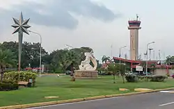
La Chinita International Airport
La Chinita International Airport (IATA: MAR, ICAO: SVMC) is an airport serving Maracaibo, the capital of Zulia. It is located southwest of Maracaibo proper in the municipality of San Francisco. La Chinita is Venezuela's second most important airport in terms of passenger and aircraft movements, after Simón Bolívar International Airport near Caracas.
La Chinita International Airport Aeropuerto Internacional La Chinita | |||||||||||||||
|---|---|---|---|---|---|---|---|---|---|---|---|---|---|---|---|
 | |||||||||||||||
| Summary | |||||||||||||||
| Airport type | Military/Public | ||||||||||||||
| Operator | Government | ||||||||||||||
| Location | San Francisco, Zulia | ||||||||||||||
| Elevation AMSL | 235 ft / 72 m | ||||||||||||||
| Coordinates | 10°33′30″N 71°43′40″W | ||||||||||||||
| Map | |||||||||||||||
.svg.png.webp) MAR Location of the airport in Venezuela | |||||||||||||||
| Runways | |||||||||||||||
| |||||||||||||||
| Statistics (2008) | |||||||||||||||
| |||||||||||||||
History
The airport opened on 16 November 1969, during the administration of President of Venezuela Rafael Caldera, to open a gateway to the western part of the country and to alleviate congestion from Simón Bolívar International Airport, which manages about half of the international flights in Venezuela. The earlier airport was Grano de Oro (1960 diagram)
Facilities
Runway 03L/21R length does not include a 300 metres (980 ft) paved overrun on the north end. The Maracaibo VORTAC (Ident: MAR) is located 0.81 nautical miles (1.50 km) northeast of the threshold of Runway 21R.[4]
Airlines and destinations
Accidents and incidents
- On 1 November 1971, Vickers Viscount YV-C-AMZ of Linea Aeropostal Venezolana crashed shortly after take-off. All four people on board were killed.[5]
External links
- Airport information for MAR at Great Circle Mapper.
- SkyVector - La Chinita
- OurAirports - La Chinita
- OpenStreetMap - La Chinita
- Airport information for SVMC at World Aero Data. Data current as of October 2006.
References
- Dirección de Operaciones
- World Data Aero
- Google Maps - La Chinita
- MAR VOR
- "Accident description". Aviation Safety Network. Retrieved 8 October 2009.