Koboko District
Koboko District is a district in the Northern Region of Uganda. The town of Koboko is the site of the district headquarters.
Koboko District | |
|---|---|
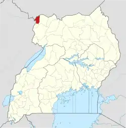
 District location in Uganda | |
| Coordinates: 03°25′N 30°58′E | |
| Country | |
| Region | Northern Region of Uganda |
| Sub-region | West Nile sub-region |
| Capital | Koboko |
| Area | |
| • Total | 759.7 km2 (293.3 sq mi) |
| Elevation | 1,285 m (4,216 ft) |
| Population (2012 Estimate) | |
| • Total | 236,900 |
| • Density | 311.8/km2 (808/sq mi) |
| Time zone | UTC+3 (EAT) |
| Website | www |
Location
Koboko District is bordered by South Sudan to the north, Yumbe District to the east, Maracha District to the south, and the Democratic Republic of the Congo (DRC) to the west. The district headquarters are located approximately 55 kilometres (34 mi), by road, north of Arua, the largest town in the sub-region.[1] This is approximately 480 kilometres (300 mi), by road, north-west of Kampala, the capital and largest city of Uganda.[2]
Overview
Koboko District consists of two counties namely, Koboko North and Koboko South. The Koboko North County consists of the Aringa Speaking Community Inclined to Lugbara and the South Inclined to the Pure Kakwa Speaking.[3][4]
Population
In 1991, the national population census estimated the district population at 62,300. The 2002 national census estimated the population at 129,100, of whom 65,400 (50.6 percent) were female and 63,800 (49.4 percent) were male. The annual population growth rate, between 2002 and 2012, was calculated at 6.4 percent. In 2012, the population was approximately 236,900.[5]
Landmarks
The district is the location of a tripoint, where the international borders of the DRC, South Sudan, and Uganda intersect.
See also
References
- "Map Showing Arua And Koboko With Distance Marker". Globefeed.com. Retrieved 26 May 2014.
- "Distance Between Kampala And Koboko With Map". Globefeed.com. Retrieved 26 May 2014.
- Districts of Uganda, Statoids, accessed 3 August 2015
- Counties of Uganda, Statoids, accessed 3 August 2015
- "Estimated Population of Koboko District In 1991, 2002 & 2012". Citypopulation.de. Retrieved 26 May 2014.