Keppel Bay
Keppel Bay is a bay in Central Queensland, Australia at the mouth of the Fitzroy River on the coast of the Coral Sea.
| Keppel Bay | |
|---|---|
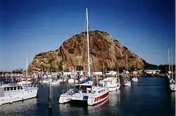
 Boats anchored at Rosslyn Bay Harbour, on Keppel Bay | |
 Keppel Bay | |
| Location | Central Queensland |
| Coordinates | 23.389°S 150.898°E[1] |
| River sources | Fitzroy River |
| Ocean/sea sources | Coral Sea |
| Basin countries | Australia |
Extent
Keppel Bay extends from Station Point on Curtis Island (23.4500°S 151.0167°E) in the Gladstone Region to Zilzie Point at Zilzie (23.2797°S 150.8247°E) in the Shire of Livingstone.[2][1][3][4]
Islands
The named islands in Keppel Bay from north to south are:[5]
- Round Rock off Zilzie (23.2990°S 150.8321°E)[6]
- Flat Rock off Coorooman (23.3142°S 150.8489°E)[7]
- Girt Island off Keppel Sands / Joskleigh (23.3561°S 150.8137°E)[8]
- Shelly Knob off Curtis Island (23.5005°S 150.9869°E)[9]
- Satellite Island in the Fitzroy River mouth off Port Alma (23.5075°S 150.7136°E)[10]
- Mackenzie Island in the Fitzroy River mouth off Thompson Point (23.5108°S 150.8641°E)[11]
- Egg Island in the Fitzroy River mouth off Thompson Point (23.5219°S 150.8306°E)[12]
- Mud Island in the Fitzroy River mouth off Thompson Point (23.5266°S 150.8516°E)[13]
- Balaclava Island in the Fitzroy River mouth off The Narrows (23.5836°S 150.9230°E)[14]
Despite the name, the islands in Keppel Bay Islands National Park are not within Keppel Bay but are to the north and east of the bay.[5]
History
Keppel Bay was named by Captain Cook when he was there on 27 May 1770, after Admiral Augustus Keppel of the British Royal Navy.[1][15]
View

References
- "Keppel Bay – bay in Livingstone Shire (entry 17997)". Queensland Place Names. Queensland Government. Retrieved 4 February 2021.
- "Bays - Queensland". Queensland Open Data. Queensland Government. 12 November 2020. Archived from the original on 25 November 2020. Retrieved 25 November 2020.
- "Station Point – cape in Gladstone Region (entry 32297)". Queensland Place Names. Queensland Government. Retrieved 4 February 2021.
- "Zilzie Point – point in Shire of Livingstone (entry 38858)". Queensland Place Names. Queensland Government. Retrieved 4 February 2021.
- "Queensland Globe". State of Queensland. Retrieved 4 February 2021.
- "Round Rock – rock in Livingstone Shire (entry 29205)". Queensland Place Names. Queensland Government. Retrieved 27 December 2020.
- "Flat Rock – rock in Livingstone Shire (entry 12729)". Queensland Place Names. Queensland Government. Retrieved 27 December 2020.
- "Girt Island – island in Livingstone Shire (entry 13848)". Queensland Place Names. Queensland Government. Retrieved 27 December 2020.
- "Shelly Knob – island in Gladstone Regional (entry 30697)". Queensland Place Names. Queensland Government. Retrieved 27 December 2020.
- "Satellite Island – island in Rockhampton Regional (entry 29976)". Queensland Place Names. Queensland Government. Retrieved 29 December 2020.
- "Mackenzie Island – island in Livingstone Shire (entry 20452)". Queensland Place Names. Queensland Government. Retrieved 27 December 2020.
- "Egg Island – island (entry 11267)". Queensland Place Names. Queensland Government. Retrieved 25 November 2020.
- "Mud Island – island in Livingstone Shire (entry 23270)". Queensland Place Names. Queensland Government. Retrieved 27 December 2020.
- "Balaclava Island – island in Gladstone Regional (entry 1286)". Queensland Place Names. Queensland Government. Retrieved 27 December 2020.
- Captain Cook's Journal During the First Voyage Round the World at Project Gutenberg
External links
- University of Queensland:Queensland Places: Keppel Bay Area
- David A. Ryan, Helen C. Bostock, Brendan P. Brooke, Darren Skene: Geomorphology and Stratigraphy of Keppel Bay, South-East Queensland, Australia, Geoscience Australia, 2009
This article is issued from Wikipedia. The text is licensed under Creative Commons - Attribution - Sharealike. Additional terms may apply for the media files.
