Jackson Creek (Toronto)
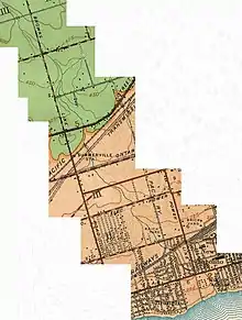
Jackson Creek is a watercourse that flows into Lake Ontario near 10th Street, in the New Toronto neighbourhood of Etobicoke, a suburb of Toronto, Ontario, Canada.[1] It is part of the Great Lakes Basin. Its headwaters were approximately five kilometers northwest—north of Bloor Street, near Highway 427.[2] Portions of the watercourse remain above-ground today.[3] The creek is named for Jackson Farm, the historical location of its mouth.[3]
| Jackson Creek | |
|---|---|
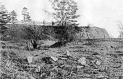
 Mouth of Jackson Creek, circa 1900 | |
 Jackson Creek in Etobicoke, Ontario | |
 Location of the mouth of the creek in Toronto | |
| Etymology | Named for Jackson Farm, the historical location of its mouth |
| Location | |
| Country | Canada |
| Province | Ontario |
| Region | Greater Toronto Area |
| Municipality | Toronto |
| Physical characteristics | |
| Source | ditch |
| • location | Islington-City Centre West |
| • coordinates | 43°37′27″N 79°32′53″W |
| • elevation | 113 m (371 ft) |
| Mouth | Lake Ontario |
• location | New Toronto |
• coordinates | 43°35′39″N 79°30′23″W |
• elevation | 74 m (243 ft) |
| Basin features | |
| River system | Great Lakes Basin |
Even though lost, for now, Jackson Creek is a strong candidate for day-lighting with grassroots movements and official[4] proceedings backing the move.
The creek west of Jackson Creek is North Creek, while the creek east of Jackson Creek is Superior Creek.

Now dry bridge underneath Canpa Rail Spur
See also
References
-
"Citizens Concerned About the Future of the Etobicoke Waterfront".
This creek originally started near Bloor Street and emptied into Lake Ontario in this park at the foot of Tenth Street. It has been buried in a pipe for over 60 years.
- "Public Transit Infrastructure Development and Implications". Friends of Jackson Creek. 2015-04-06.
- Harrison, Michael (2009-10-13). "Jackson Creek". Lost creeks of south Etobicoke. Retrieved 2012-01-19.
- "Etobicoke and Mimico Watersheds" (PDF). 2013-10-15.
| Wikimedia Commons has media related to Jackson Creek (Toronto). |
This article is issued from Wikipedia. The text is licensed under Creative Commons - Attribution - Sharealike. Additional terms may apply for the media files.