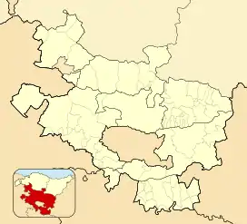
Iruraiz-Gauna
Iruraiz-Gauna (Spanish pronunciation: [iɾuˈɾajθ ˈɣawna], Basque pronunciation: [iɾu.ɾajs̪ ɣawna])[3] is a municipality located in the province of Álava, in the Basque Country, northern Spain.
Iruraiz-Gauna | |
|---|---|
 Coat of arms | |
 Iruraiz-Gauna Location within Álava  Iruraiz-Gauna Location within Spain | |
| Coordinates: 42°49′40″N 2°30′00″W | |
| Country | Spain |
| Autonomous Community | Basque Country |
| Province | Álava |
| Cuadrilla | Llanada Alavesa |
| Government | |
| • Mayor | Susana Díaz de Arcaya Cubillo[1] (EAJ-PNV) |
| Area | |
| • Total | 47.6 km2 (18.4 sq mi) |
| Elevation (AMSL) | 625 m (2,051 ft) |
| Population (2018)[2] | |
| • Total | 517 |
| • Density | 11/km2 (28/sq mi) |
| Time zone | UTC+1 (CET) |
| • Summer (DST) | UTC+2 (CEST) |
| Postal code | 01206, 01207, 01993 |
| Website | www |
Geography
Administrative subdivisions
Iruraiz-Gauna is divided into 11 villages, all of which are organized as concejos. Two parts of the municipality aren't integrated in any concejo: the Comunal de Ilarra and Orgazi.
| Arms | Official name[note 1] | Basque name | Spanish name | Population [4] | Area (km2) | Notes |
|---|---|---|---|---|---|---|
| Alaitza | Alaitza | Alaiza | 65 | 3.76 | Concejo | |
| Arrieta | Arrieta | Arrieta | 41 | 3.40 | Concejo | |
| Azilu | Azilu | Acilu | 27 | 1.27 | Concejo | |
| – | Comunal de Ilarra | Ilarrako erkidegoa | Comunal de Ilarra | – | 0.59 | Agricultural common managed by Gazeo, Ezkerekotxa and Langarika.[5] |
| Erentxun | Erentxun | Erenchun | 80 | 7.66 | Concejo | |
| Ezkerekotxa | Ezkerekotxa | Ezquerecocha | 43 | 4.78 | Concejo | |
| Gauna | Gauna | Gauna | 68 | 5.96 | Concejo | |
| Gazeo | Gazeo | Gaceo | 50 | 2.44 | Concejo | |
| – | Gereñu | Gereñu | Guereñu | 36 | 5.12 | Concejo |
| – | Jauregi | Jauregi | Jáuregui | 8 | 3.35 | Concejo |
| – | Orgazi | Orgazi | Orgaci | – | 0.50 | Uninhabited enclave in Vitoria-Gasteiz. Also known as Uriarte.[6] |
| Langarika | Langarika | Langarica | 33 | 4.16 | Concejo | |
| Trokoniz | Trokoniz | Trocóniz | 83 | 4.53 | Concejo |
Notes
- The official names of the villages that constitute the municipality are in Basque.
References
- "Susana Díaz de Arcaya Cubillo". Guía de Comunicación Abierta (in Spanish). euskadi.eus. Retrieved 26 March 2020.
- Municipal Register of Spain 2018. National Statistics Institute.
- "150. arauaː Arabako herri izendegia" (PDF). Euskaltzaindia (in Basque). Retrieved 26 March 2020.
- "Demografía". Ayuntamiento Iruraiz-Gauna (in Spanish). Retrieved 26 March 2020.
- "Anuncio de la declaración en estado de deslinde del Monte de Utilidad Pública nº 521 denominado "Ilarra", de la pertenencia de la Comunidad de los pueblos de Gazeo, Ezkerekotxa y Langarika y ubicado en el término municipal de Iruraiz-Gauna, conforme a lo establecido por la Norma Foral de Montes del Territorio Histórico de Alava en su artículo 28". BOTHA (in Spanish) (131). Departamento de Agricultura. Servicio de Montes. 14 November 2008. Retrieved 26 March 2020.
- "Historia de Orgazi y Uriarte". Ayuntamiento Iruraiz-Gauna (in Spanish). Retrieved 26 March 2020.
This article is issued from Wikipedia. The text is licensed under Creative Commons - Attribution - Sharealike. Additional terms may apply for the media files.