Hatton Vale
Hatton Vale is a rural locality in the Lockyer Valley Region, Queensland, Australia.[2] In the 2016 census, Hatton Vale had a population of 1,521 people.[1]
| Hatton Vale Queensland | |||||||||||||||
|---|---|---|---|---|---|---|---|---|---|---|---|---|---|---|---|
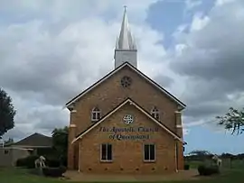
 Hatton Vale Apostolic Cathedral, 2011 | |||||||||||||||
 Hatton Vale | |||||||||||||||
| Coordinates | 27.5613°S 152.4761°E | ||||||||||||||
| Population | 1,521 (2016 census)[1] | ||||||||||||||
| • Density | 70.09/km2 (181.5/sq mi) | ||||||||||||||
| Postcode(s) | 4341 | ||||||||||||||
| Area | 21.7 km2 (8.4 sq mi) | ||||||||||||||
| Time zone | AEST (UTC+10:00) | ||||||||||||||
| Location | |||||||||||||||
| LGA(s) | Lockyer Valley Region | ||||||||||||||
| State electorate(s) | Lockyer | ||||||||||||||
| Federal Division(s) | Wright | ||||||||||||||
| |||||||||||||||
Geography
Hatton Vale is in South East Queensland and on the Warrego Highway, 72 kilometres (45 mi) west of the state capital Brisbane and 36 kilometres (22 mi) west of the regional centre of Ipswich.
History
Hatton Vale, originally known as "Tarampa Woolshed" was settled by German migrants in the 1870s as part of a closer settlement arrangement.[3] The migrants established a Lutheran church in 1881 and an Apostolic church in 1889. The missionary Heinrich Friedrich Niemeyer established Hatton Vale as a centre for the Apostolic church in Queensland.[3]
Hatton Vale Provisional School opened in 1881. On 18 October 1886, it became Hatton Vale State School.[3][4]
Hatton Vale Post Office opened by 1903 (a receiving office had been open from 1881, known as Woolshed Creek until 1889) and closed in 1974.[5]
The locality remained overwhelmingly German in character. A survey in 1902 identified 90% of the farmers in the area had German surnames and this was still the case in 1949.[3]
In 1939 the Apostolic Church of Queensland decided to build a cathedral, but its construction was delayed by World War II and then by a shortage of building materials. The foundation stone was finally laid on 4 September 1948. The Hatton Vale Apostolic Cathedral was dedicated on Saturday 2 December 1950 by the Australian leader of the church, Apostle E. Zielke of Bundaberg. The ceremony was attended by nearly 2,000 people.[3] The church has a 91-foot (28 m) spire, making it a landmark in the district.[6]
Since 1990, Hatton Vale has seen significant residential development and become a dormitory suburb for nearby urban centres.[3]
At the 2011 census, Hatton Vale and the surrounding area had a population of 1,138.[7]
Amenities
The locality hosts the headquarters of the Apostolic Church of Queensland along with a 1,200 seat church at 3 Niemeyer Road (27.5616°S 152.4529°E).[3]
Other facilities in the locality include local shopping, a golf course and recreation club, and a community church (additional to the Apostolic cathedral).[3]
Education
Hatton Vale State School is a government primary (Early Childhood-6) school for boys and girls at Hannant Road (27.5434°S 152.4709°E).[8][9] In 2017, the school had an enrolment of 441 students with 33 teachers (31 full-time equivalent) and 23 non-teaching staff (15 full-time equivalent).[10] It includes a special education program.[8]
There are no secondary schools in Hatton Vale. The nearest are in Laidley, Rosewood and Lowood.[11]
References
- Australian Bureau of Statistics (27 June 2017). "Hatton Vale (SSC)". 2016 Census QuickStats. Retrieved 20 October 2018.

- "Hatton Vale – locality in Lockyer Valley Region (entry 44958)". Queensland Place Names. Queensland Government. Retrieved 16 November 2019.
- "Hatton Vale". Queensland Places. University of Queensland. Retrieved 7 November 2012.
- Queensland Family History Society (2010), Queensland schools past and present (Version 1.01 ed.), Queensland Family History Society, ISBN 978-1-921171-26-0
- Premier Postal History. "Post Office List". Premier Postal Auctions. Retrieved 10 May 2014.
- "NEW APOSTOLIC CHURCH AT HATTON VALE DEDICATED". Queensland Times (19, 944). Queensland, Australia. 4 December 1950. p. 2 (DAILY). Retrieved 23 September 2020 – via National Library of Australia.
- Australian Bureau of Statistics (31 October 2012). "Hatton Vale (SSC)". 2011 Census QuickStats. Retrieved 8 November 2011.

- "State and non-state school details". Queensland Government. 9 July 2018. Archived from the original on 21 November 2018. Retrieved 21 November 2018.
- "Hatton Vale State School". Retrieved 21 November 2018.
- "ACARA School Profile 2017". Archived from the original on 22 November 2018. Retrieved 22 November 2018.
- "Queensland Globe". State of Queensland. Retrieved 17 November 2019.
External links
![]() Media related to Hatton Vale, Queensland at Wikimedia Commons
Media related to Hatton Vale, Queensland at Wikimedia Commons