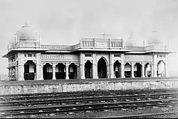
Guna, India
Guna is a city and a municipality in Guna district in the Indian state of Madhya Pradesh. It is the administrative headquarters of Guna District and is located on the banks of Parbati river.
Guna | |
|---|---|
City | |
 Guna railway station, 1890 | |
 Guna Location in Madhya Pradesh, India  Guna Guna (India) | |
| Coordinates: 24.65°N 77.32°E | |
| Country | |
| State | Madhya Pradesh |
| District | Guna |
| Area | |
| • Total | 84 km2 (32 sq mi) |
| Elevation | 474 m (1,555 ft) |
| Population (2011)[1] | |
| • Total | 180,935 |
| • Density | 2,155/km2 (5,580/sq mi) |
| Language | |
| • Official | Hindi[2] |
| Time zone | UTC+5:30 (IST) |
| PIN | 473001 |
| Telephone code | 91 7542 |
| ISO 3166 code | IN-MP |
| Vehicle registration | MP-08 |
| Sex ratio | 910 ♂/♀ |
Geography
Guna is located at 24.65°N 77.32°E.[3] It has an average elevation of 474 metres (1555 ft).
Climate
| Climate data for Guna, India (1981–2010, extremes 1932–2011) | |||||||||||||
|---|---|---|---|---|---|---|---|---|---|---|---|---|---|
| Month | Jan | Feb | Mar | Apr | May | Jun | Jul | Aug | Sep | Oct | Nov | Dec | Year |
| Record high °C (°F) | 33.5 (92.3) |
37.8 (100.0) |
42.0 (107.6) |
45.8 (114.4) |
47.8 (118.0) |
46.8 (116.2) |
43.0 (109.4) |
39.2 (102.6) |
39.5 (103.1) |
39.3 (102.7) |
37.0 (98.6) |
32.9 (91.2) |
47.8 (118.0) |
| Average high °C (°F) | 24.6 (76.3) |
27.6 (81.7) |
33.5 (92.3) |
38.7 (101.7) |
41.5 (106.7) |
38.9 (102.0) |
32.3 (90.1) |
30.3 (86.5) |
32.0 (89.6) |
33.1 (91.6) |
29.8 (85.6) |
26.5 (79.7) |
32.4 (90.3) |
| Average low °C (°F) | 9.1 (48.4) |
11.4 (52.5) |
16.6 (61.9) |
21.8 (71.2) |
26.3 (79.3) |
26.6 (79.9) |
24.4 (75.9) |
23.4 (74.1) |
22.5 (72.5) |
18.4 (65.1) |
13.5 (56.3) |
9.6 (49.3) |
18.6 (65.5) |
| Record low °C (°F) | −2.2 (28.0) |
−1.1 (30.0) |
4.7 (40.5) |
11.1 (52.0) |
16.7 (62.1) |
19.4 (66.9) |
19.1 (66.4) |
19.4 (66.9) |
13.1 (55.6) |
8.3 (46.9) |
2.8 (37.0) |
−1.7 (28.9) |
−2.2 (28.0) |
| Average rainfall mm (inches) | 9.4 (0.37) |
10.9 (0.43) |
8.4 (0.33) |
4.2 (0.17) |
13.2 (0.52) |
95.8 (3.77) |
303.8 (11.96) |
326.8 (12.87) |
162.3 (6.39) |
24.4 (0.96) |
11.2 (0.44) |
3.4 (0.13) |
973.7 (38.33) |
| Average rainy days | 1.0 | 0.8 | 0.7 | 0.5 | 1.4 | 4.6 | 12.8 | 13.3 | 6.8 | 1.6 | 0.6 | 0.5 | 44.5 |
| Average relative humidity (%) (at 17:30 IST) | 41 | 32 | 23 | 18 | 21 | 39 | 69 | 78 | 64 | 42 | 42 | 43 | 43 |
| Source: India Meteorological Department[4][5] | |||||||||||||
Demographics
As of 2011 Indian Census, Guna had a total population of 180,935, of which 94,464 were males and 86,471 were females. Population within the age group of 0 to 6 years was 24,447. The total number of literates in Guna was 125,295, which constituted 69.2% of the population with male literacy of 75.3% and female literacy of 62.6%. The effective literacy rate of 7+ population of Guna was 80.1%, of which male literacy rate was 87.2% and female literacy rate was 72.3%. The Scheduled Castes and Scheduled Tribes population was 27,631 and 3,623 respectively. Guna had 34383 households in 2011.[1]
As of 2001 India census, Guna has a population of 137,132. Males constitute 52.8% of the population and females 47.2%. Total number of literates was 91,322, giving a crude literacy rate 66.6% and an effective literacy rate of 78.4%. In Guna, a population of 20,648 (15%) was in the age range of 0–6 years.[6]
Education
For higher education engineering private college Jaypee University of Engineering & Technology (JUET) situated near guna around 35 km.
References
- "Census of India: Guna". www.censusindia.gov.in. Retrieved 22 January 2020.
- "52nd Report of the Commissioner for Linguistic Minorities in India" (PDF). nclm.nic.in. Ministry of Minority Affairs. Archived from the original (PDF) on 25 May 2017. Retrieved 6 June 2019.
- Falling Rain Genomics, Inc - Guna
- "Station: Guna Climatological Table 1981–2010" (PDF). Climatological Normals 1981–2010. India Meteorological Department. January 2015. pp. 303–304. Archived from the original (PDF) on 5 February 2020. Retrieved 29 December 2020.
- "Extremes of Temperature & Rainfall for Indian Stations (Up to 2012)" (PDF). India Meteorological Department. December 2016. p. M118. Archived from the original (PDF) on 5 February 2020. Retrieved 29 December 2020.
- "Census of India 2001: Data from the 2001 Census, including cities, villages and towns (Provisional)". Census Commission of India. Archived from the original on 16 June 2004. Retrieved 1 November 2008.