Franklin, Kentucky
Franklin is a home rule-class city[3] in and the county seat of Simpson County, Kentucky, United States.[4] The county is located on the south central border of the state, and its population was 8,408 at the 2010 census.
Franklin, Kentucky | |
|---|---|
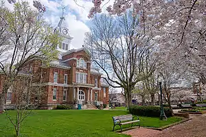
 Simpson County Courthouse in Franklin | |
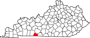
 Location of Franklin in Simpson County, Kentucky. | |
| Coordinates: 36°43′21″N 86°34′39″W | |
| Country | United States |
| State | Kentucky |
| County | Simpson |
| Established | November 2, 1820 |
| Government | |
| • Type | City Commission |
| Area | |
| • Total | 14.73 sq mi (38.14 km2) |
| • Land | 14.62 sq mi (37.85 km2) |
| • Water | 0.11 sq mi (0.29 km2) |
| Elevation | 709 ft (216 m) |
| Population (2010) | |
| • Total | 8,408 |
| • Estimate (2019)[2] | 9,010 |
| • Density | 616.49/sq mi (238.03/km2) |
| Time zone | UTC-6 (Central (CST)) |
| • Summer (DST) | UTC-5 (CDT) |
| ZIP codes | 42134-42135 |
| Area code(s) | 270 & 364 |
| FIPS code | 21-28918 |
| GNIS feature ID | 0492443 |
| Website | www |
Kentucky Downs, formerly known as Dueling Grounds Racetrack (owned by Corey Johnsen & Ray Reid), is located in Franklin on the Kentucky–Tennessee border. Kentucky Downs hosts the Kentucky Cup Turf Festival, a full card of world-class horse racing featuring four major turf stakes. Kentucky Downs also hosts year-round simulcasts for the Kentucky-Tennessee market.
History
Franklin was formally incorporated by the state assembly on November 2, 1820,[5] on a 62-acre (250,000 m2) tract of land. This tract was purchased from William Hudspeth and was named for Founding Father Benjamin Franklin.[6] The post office was established on September 29, 1822, with Robert W. Simpson as postmaster.[7]
On March 1, 1968, Johnny Cash and June Carter Cash were married at the Franklin First United Methodist church by Reverend Leslie Chapman.
Climate
The climate in this area is characterized by hot, humid summers and generally mild to cool winters. According to the Köppen Climate Classification system, Franklin has a humid subtropical climate, abbreviated "Cfa" on climate maps.[8]
Geography
Franklin is located at 36°43′21″N 86°34′39″W (36.722487, -86.577566).[9]
According to the United States Census Bureau, the city has a total area of 7.4 square miles (19 km2), all land.
Demographics
| Historical population | |||
|---|---|---|---|
| Census | Pop. | %± | |
| 1830 | 280 | — | |
| 1860 | 828 | — | |
| 1870 | 1,808 | 118.4% | |
| 1880 | 1,686 | −6.7% | |
| 1890 | 2,324 | 37.8% | |
| 1900 | 2,166 | −6.8% | |
| 1910 | 3,063 | 41.4% | |
| 1920 | 3,154 | 3.0% | |
| 1930 | 3,056 | −3.1% | |
| 1940 | 3,940 | 28.9% | |
| 1950 | 4,343 | 10.2% | |
| 1960 | 5,329 | 22.7% | |
| 1970 | 6,553 | 23.0% | |
| 1980 | 7,738 | 18.1% | |
| 1990 | 7,607 | −1.7% | |
| 2000 | 7,996 | 5.1% | |
| 2010 | 8,408 | 5.2% | |
| 2019 (est.) | 9,010 | [2] | 7.2% |
| U.S. Decennial Census[10] | |||
As of the census[11] of 2000, there were 7,996 people, 3,251 households, and 2,174 families residing in the city. The population density was 1,074.7 people per square mile (415.0/km2). There were 3,609 housing units at an average density of 485.1 per square mile (187.3/km2). The racial makeup of the city was 80.99% White, 16.76% African American, 0.21% Native American, 0.76% Asian, 0.10% Pacific Islander, 0.26% from other races, and 0.91% from two or more races. Hispanic or Latino of any race were 0.81% of the population.
There were 3,251 households, out of which 31.1% had children under the age of 18 living with them, 48.1% were married couples living together, 14.8% had a female householder with no husband present, and 33.1% were non-families. 29.5% of all households were made up of individuals, and 13.7% had someone living alone who was 65 years of age or older. The average household size was 2.39 and the average family size was 2.94.
In the city, the population was spread out, with 25.2% under the age of 18, 9.1% from 18 to 24, 28.5% from 25 to 44, 21.8% from 45 to 64, and 15.4% who were 65 years of age or older. The median age was 36 years. For every 100 females, there were 89.9 males. For every 100 females age 18 and over, there were 85.7 males.
The median income for a household in the city was $32,001, and the median income for a family was $38,807. Males had a median income of $30,955 versus $21,783 for females. The per capita income for the city was $16,467. About 10.9% of families and 13.7% of the population were below the poverty line, including 15.9% of those under age 18 and 18.1% of those age 65 or over.
Education
Public education in Franklin is administered by Simpson County School District, which operates Franklin Elementary School, Lincoln Elementary School and Simpson Elementary School, Franklin-Simpson Middle School and Franklin-Simpson High School.[12]
Franklin Mennonite Elementary School and Faith Baptist Academy are private institutions.
Franklin has a public library, the Goodnight Memorial Library.[13]
Notable people
- Joe Blanton (1980–), Major League Baseball pitcher, was raised in Franklin
- Marty Brown (1965–), country singer-songwriter born in Maceo and moved to Franklin in 2004
- Thomas Chisholm (1866-1960), Christian songwriter who wrote "Great is Thy Faithfulness", was born in Franklin
- Carolyn Denning (1927–2016), pediatrician and pioneer in cystic fibrosis treatment, grew up in Franklin
- James Earnest (1818–1900), member of the Wisconsin State Assembly and Wisconsin State Senate, was born in Franklin
- Brad M. Kelley (1956–), billionaire businessman, came from Franklin
- Carolyn Conn Moore (1904–1986) of Franklin was elected as the first woman to serve in the Kentucky Senate in November 1949, after a special election to replace her husband, the late J. Lee Moore, after his death.[14]
- Kenny Perry (1960–), a PGA golfer, spent most of his childhood in Franklin. Today he operates a golf course there
- Joker Phillips (1963–), pro football player, was born and raised in Franklin; he attended and played football at University of Kentucky. Current NFL coach
- Annie Potts (1952–), actress (Ghostbusters, Pretty in Pink), was raised in Franklin
- Tony Randolph, member of the South Dakota House of Representatives
See also
- List of cities in Kentucky
- Mantell UFO Incident- Franklin has a roadside historical marker for this incident.
References
- "2019 U.S. Gazetteer Files". United States Census Bureau. Retrieved July 24, 2020.
- "Population and Housing Unit Estimates". United States Census Bureau. May 24, 2020. Retrieved May 27, 2020.
- "Summary and Reference Guide to House Bill 331 City Classification Reform" (PDF). Kentucky League of Cities. Retrieved December 30, 2014.
- "Find a County". National Association of Counties. Archived from the original on 2011-05-31. Retrieved 2011-06-07.
- Commonwealth of Kentucky. Office of the Secretary of State. Land Office. "Franklin, Kentucky". Accessed 26 July 2013.
- Gannett, Henry (1905). The Origin of Certain Place Names in the United States. Govt. Print. Off. pp. 131.
- Rennick, Robert M. (1988). "Place Names". Kentucky Place Names. Lexington: The University Press of Kentucky. ISBN 0-8131-0179-4. Accessed 5 May 2010.
- Climate Summary for Franklin, Kentucky
- "US Gazetteer files: 2010, 2000, and 1990". United States Census Bureau. 2011-02-12. Retrieved 2011-04-23.
- "Census of Population and Housing". Census.gov. Retrieved June 4, 2015.
- "U.S. Census website". United States Census Bureau. Retrieved 2008-01-31.
- "Homepage". Simpson County Schools. Retrieved 7 June 2019.
- "Kentucky Public Library Directory". Kentucky Department for Libraries and Archives. Archived from the original on 11 January 2019. Retrieved 7 June 2019.
- Oswald, Sharon (5 January 1977). "From senate to housemother, Mrs. Moore is mother of 110". The Tuscaloosa News. Tuscaloosa: The Tuscaloosa News. p. 8. Retrieved 15 March 2010.
External links
| Wikimedia Commons has media related to Franklin, Kentucky. |
| Wikivoyage has a travel guide for Franklin, Kentucky. |
