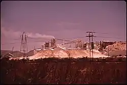
Forrest, Arizona
Forrest was a populated place situated in Cochise County, Arizona.[2] It has an estimated elevation of 4,196 feet (1,279 m) above sea level.[1]
Forrest, Arizona | |
|---|---|
Populated place | |
 Paul Lime Plant in 1972 | |
 Forrest Location within the state of Arizona  Forrest Forrest (the United States) | |
| Coordinates: 31°22′00″N 109°43′39″W | |
| Country | United States |
| State | Arizona |
| County | Cochise |
| Elevation | 4,196 ft (1,279 m) |
| Time zone | UTC-7 (Mountain (MST)) |
| • Summer (DST) | UTC-7 (MST) |
| Area code(s) | 520 |
| FIPS code | 04-24180 |
| GNIS feature ID | 24420 |
Forrest was on the El Paso and Southwestern Railroad, it was named for a local old resident and rancher.[3]
The Paul Lime Plant began operating nearby in 1918[4] and the railway spur to there was renamed Paul's Spur.[5] By the 1940s it was the largest lime producer in Southern Arizona.[4]
Forrest had a post office that opened on May 8, 1914.[3] Forrest School was twice destroyed by fire, once in 1915 and again in 1929 when it was replaced by a larger brick building.[5] At one time up to 200 families lived nearby working in the lime plant.[5] However following mechanisation the population dropped and the school closed in 1963.[5] Forrest School District continued in existence organising transport to schools in Douglas.[5]
References
- "Feature Detail Report for: Forrest". Geographic Names Information System. United States Geological Survey.
- "Forrest (in Cochise County, AZ) Populated Place Profile". AZ Hometown Locator. Retrieved November 18, 2016.
- Barnes, Will Croft (2016). Arizona Place Names. University of Arizona Press. p. 166. ISBN 9780816534951. Retrieved February 21, 2020.
- Wilson, Eldred Dewey; Galbraith, Frederic Williams (1944), Arizona Nonmetallics: A Summary of Past Production and Present Operations, University of Arizona, pp. 24–40
- Ellioit, Ruth D. (1974). "=Forrest School" (PDF). The Chohise Quarterly. Cochise County Historical and Archaeological Society. 4 (2&3): 29–30.
