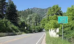
Eldorado Springs, Colorado
Eldorado Springs is an unincorporated community, a census-designated place (CDP), and a post office located in and governed by Boulder County, Colorado, United States. The CDP is a part of the Boulder, CO Metropolitan Statistical Area. The Eldorado Springs post office has the ZIP code 80025 (post office boxes).[3] At the United States Census 2010, the population of the Eldorado Springs CDP was 585, while the population of the 80025 ZIP Code Tabulation Area was 253.[4]
Eldorado Springs, Colorado | |
|---|---|
 Eldorado Springs in 2014. | |
 Location of the Eldorado Springs CDP in Boulder County, Colorado. | |
 Eldorado Springs Location of the Eldorado Springs CDP in the United States. | |
| Coordinates: 39°56′12″N 105°15′45″W[1] | |
| Government | |
| • Type | unincorporated community |
| Area | |
| • Total | 2.585 sq mi (6.696 km2) |
| • Land | 2.584 sq mi (6.692 km2) |
| • Water | 0.002 sq mi (0.004 km2) |
| Elevation | 5,682 ft (1,732 m) |
| Population (2010) | |
| • Total | 585 |
| • Density | 226/sq mi (87/km2) |
| Time zone | UTC-7 (MST) |
| • Summer (DST) | UTC-6 (MDT) |
| ZIP Code[3] | 80025 |
| Area codes | 303 & 720 |
| GNIS feature[2] | Eldorado Springs CDP |
The nearby Eldorado Canyon State Park is famous for its classic North-American climbing routes.
History
In 1910, Eldorado Springs was a resort community, known for its Big Radium Pool, then the largest swimming pool in the United States. The pool, along with several other smaller ones, was known as "Coney Island of the West."[5] In 1916, Dwight and Mamie Eisenhower celebrated their honeymoon in one of the cabins at the resort.[6] Also known for its good tasting spring water, "Eldorado Springs" bottled water is sold in stores around Colorado.
Notable residents
- Pansy Stockton (1895–1972), artist
- Mark Emery Udall (1950- ), U.S. Senator
Geography
The Eldorado Springs CDP has an area of 1,655 acres (6.696 km2), including 0.99 acres (0.004 km2) of water.[1] To the southwest is Eldorado Mountain.
| Climate data for Eldorado Springs, Colorado | |||||||||||||
|---|---|---|---|---|---|---|---|---|---|---|---|---|---|
| Month | Jan | Feb | Mar | Apr | May | Jun | Jul | Aug | Sep | Oct | Nov | Dec | Year |
| Average high °F (°C) | 46 (8) |
49 (9) |
56 (13) |
63 (17) |
72 (22) |
81 (27) |
86 (30) |
85 (29) |
77 (25) |
65 (18) |
54 (12) |
46 (8) |
65 (18) |
| Average low °F (°C) | 22 (−6) |
23 (−5) |
29 (−2) |
36 (2) |
44 (7) |
51 (11) |
56 (13) |
55 (13) |
47 (8) |
38 (3) |
28 (−2) |
22 (−6) |
37.6 (3.1) |
| Source: Accuweather[7] | |||||||||||||
Demographics
The United States Census Bureau initially defined the Eldorado Springs CDP for the United States Census 2000.
| Year | Pop. | ±% |
|---|---|---|
| 2000 | 557 | — |
| 2010 | 585 | +5.0% |
| 2020 | — | |
| Source: United States Census Bureau | ||
See also
- Outline of Colorado
- State of Colorado
- Colorado cities and towns
- Colorado counties
- Colorado metropolitan areas
- Eldorado Canyon State Park
References
- "State of Colorado Census Designated Places - BAS20 - Data as of January 1, 2020". United States Census Bureau. Retrieved December 8, 2020.
- "U.S. Board on Geographic Names: Domestic Names". United States Geological Survey. Retrieved December 8, 2020.
- "Look Up a ZIP Code". United States Postal Service. Retrieved December 8, 2020.
- "2010: DEC Summary File 1". United States Census Bureau. Retrieved December 20, 2020.
- Exhibit at Amon Carter Museum in Fort Worth, Texas
- https://www.stateparks.com/eldorado_canyon_state_park_in_colorado.html
- "Eldorado Springs Weather". Retrieved July 6, 2015.
