Durham Wildlife Trust
Durham Wildlife Trust, founded in 1971, is a registered charity[1] which aims to protect wildlife and promote nature conservation in parts of County Durham and Tyne and Wear, England. It is one of 46 such organisations that together constitute The Wildlife Trusts Partnership.[2]
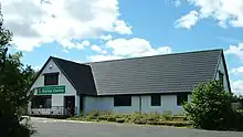
 Rainton Meadows Visitor Centre, HQ of Durham Wildlife Trust | |
| Formation | 1971 |
|---|---|
| Type | Registered charity |
| Headquarters | Rainton Meadows, Houghton-le-Spring, Tyne and Wear, England |
President | Professor David Bellamy |
| Website | www |
The Trust owns or manages 37 nature reserves, covering more than 782 ha, operates two visitor centres, and is actively involved in raising conservation awareness through educational activities.
Status and scope
Durham Wildlife Trust is a registered charity, which depends to a large extent on the support of its members, many of whom participate as volunteers in various conservation activities. The Trust's Patron is the Earl of Strathmore and Kinghorne and its President is Professor David Bellamy.
The Trust's activities cover the present unitary authorities of Durham and Darlington in County Durham and the metropolitan boroughs of Gateshead, South Tyneside and Sunderland in Tyne and Wear.
Activities
Durham Biodiversity Partnership
The Durham Biodiversity Partnership, which covers the same geographic area as Durham Wildlife Trust, was established in 1996 to oversee the development, implementation and monitoring of the Durham Biodiversity Action Plan (BAP), which is the medium through which the United Kingdom Biodiversity Action Plan is translated into action within the county of Durham. Members of the Partnership include a wide range of organisations and individuals who have an interest in the BAP.[3]
Durham Wildlife Trust plays an important role in the Partnership. It provides a home for the Partnership at Rainton Meadows, and is represented on the Partnership's steering group, alongside representatives from Natural England, the Environment Agency, the Forestry Commission, Northumbrian Water, the Farming and Wildlife Advisory Group, the North East Biodiversity Forum, and the County, City and Borough Councils within the area.[4] The Trust also operates, on behalf of the Partnership, the Durham Biodiversity Data Service, which provides high-quality species and habitat data.[5]
Durham Wildlife Services Ltd
Durham Wildlife Services is the Trust's commercial arm, providing an ecological consultancy service to businesses and local authorities. Although its customer base is primarily within Durham, it operates across the whole of the United Kingdom. A particular speciality is the preparation of "environmental stewardship" plans, under which farmers are able to obtain funding for properly managed conservation schemes on their land.[6]
Profits generated by DWS are covenanted to Durham Wildlife Trust.[7]
Education
Education is an important aspect of the Trust's work. The main education centre is at Rainton Meadows, near Houghton-le-Spring; as well as being conveniently close to the most populous parts of the county, in Sunderland, Gateshead and South Tyneside, this centre has an indoor classroom and conference centre. At Low Barns, near Bishop Auckland, there is a second education centre, which caters primarily to outdoor activities. The Trust also arranges educational activities at Hylton Dene and Hylton Castle, mainly for the benefit of local schools in the Sunderland area.[8]
In addition to educational facilities at its own sites, the Trust also has an educational outreach programme, under which Trust staff make visits schools or community groups.[9]
Projects
Durham Wildlife Trust is an active partner in a number of conservation projects in County Durham:
- Living Landscapes are schemes to restore biodiversity across the landscape by providing 'corridors' for wildlife to move between reserves and other protected areas. Durham Wildlife Trust is involved in two such schemes:
- "Heart of Durham", funded by Northumbria Water, aims to preserve and extend areas of heathland and lowland valleys in a broad area extending from Derwent Reservoir in the north to Hamsterley Forest in the south.[10]
- "Limestone Landscapes", coordinated by Durham County Council, aims to restore and enhance the unique landscape of the magnesian limestone plateau of lowland Durham.[11]
- Living Waterways is a project, in partnership with the Environment Agency, to develop sustainable methods of reducing flood risk in urban areas, while improving wildlife habitats and increasing recreational use of urban waterways.[12]
- Veteran Trees is a Durham Biodiversity Partnership project which aims to increase public awareness of the conservation and amenity value of old trees.[13]
The Trust is currently involved in projects to protect species such as the great crested newt, the water vole and the barn owl, and played an important part in helping to re-establish otters across the county's river catchments.
Nature reserves

Nature Reserves managed by the Trust include Bishop Middleham Quarry, Hawthorn Dene and Low Barns, and include a range of important habitats, such as Magnesian Limestone grasslands, upland hay meadows and coastal denes. The magnesian limestone grasslands managed by the Trust represent some of the finest examples of this particular habitat type, of which only 200 ha remain in the UK.
The Trust's largest reserve is Hedleyhope Fell, near Tow Law at over 200 ha. It is one of the finest examples of recovering mid-altitude heathland in the county – a rare habitat in County Durham. The site is very important because it supports a range of rare and uncommon flora and fauna, including lesser skullcap, stag's-horn clubmoss and the velvet ant, which has not been recorded anywhere else in the County. It is also home to a large number of breeding birds and is an important site for the green hairstreak butterfly.
Sites
The Trust currently manages the following reserves:
| Reserve [A] | Area (ha) | Grid reference [B] | Owner |
| Addison and Hedgefield | 14.0 | NZ167641 | DWT |
| Baal Hill Wood | 15.5 | NZ069392 | DWT |
| Barlow Burn | 20.0 | NZ156618 | DWT |
| Bishop Middleham Quarry | 10.0 | NZ332326 | Leased from Church Commissioners |
| Black Plantation | 13.8 | NZ137449 | DWT |
| Blackhall Rocks | 32.4 | NZ470392 | Leased from Durham County Council |
| Burnhope Pond | 14.1 | NZ183480 | Leased from Durham County Council |
| Chopwell Meadows | 17.0 | NZ113584 | DWT (part of site was former Chopwell Colliery) |
| Edmondsley Wood | 12.5 | NZ229493 | DWT |
| Hannah's Meadows | 8.8 | NY934187 | DWT |
| Hawthorn Dene | 67.0 | NZ433458 | DWT / National Trust |
| Hedleyhope Fell | 202.0 | NZ139409 | DWT |
| Hesleden Dene | 8.5 | NZ444377 | DWT |
| High Wood NR | 2.5 | NZ128562 | DWT |
| Joe's Pond | 4.5 | NZ328487 | DWT |
| Longburnford Quarry | 1.0 | NZ072448 | DWT |
| Low Barns | 50 | NZ163313 | DWT |
| Malton NR | 4.5 | NZ182458 | Leased from Durham County Council |
| Milkwellburn Wood | 79.0 | NZ114570 | DWT |
| Rabbitbank Wood | 7.0 | NZ112483 | DWT |
| Ragpath Heath | 3.5 | NZ144448 | DWT |
| Rainton Meadows | 60.0 | NZ326485 | UK Coal Ltd / City of Sunderland |
| Raisby Hill Grassland | 11.5 | NZ335355 | DWT /Tarmac |
| Redcar Field | 0.4 | NZ292198 | DWT / Natural England |
| Shibdon Pond | 13.7 | NZ194628 | Metropolitan Borough of Gateshead Council |
| Stanley Moss NR | 7.5 | NZ150388 | DWT |
| Town Kelloe Bank | 5.0 | NZ357371 | DWT |
| Trimdon Grange Quarry | 5.0 | NZ361353 | Leased from Durham County Council |
| Tudhoe Mill Wood | 37.5 | NZ254357 | DWT / Whitwirth Estates |
Notes
- A Durham Wildlife Trust has prepared short information sheets for most of its reserves. The information in this table is mostly extracted from these information sheets.[14]
- B Grid references use the British national grid reference system (OSGB36), the system used on Ordnance Survey maps.[15] The grid reference for each reserve relates to the approximate centre of the reserve.
References
- Charity Commission. Durham Wildlife Trust, registered charity no. 501038.
- "Durham Wildlife Trust". Royal Society of Wildlife Trusts. 2010. Retrieved 6 August 2010.
- "Durham Biodiversity Partnership". Durham Wildlife Trust. 2010. Archived from the original on 11 July 2010. Retrieved 6 August 2010.
- "Partnership". Durham Biodiversity Partnership. 2010. Archived from the original on 4 September 2010. Retrieved 6 August 2010.
- "Durham Biodiversity Data Service". Durham Wildlife Trust. 2010. Archived from the original on 11 July 2010. Retrieved 6 August 2010.
- "Durham Wildlife Services Ltd". 2010. Retrieved 6 August 2010.
- "Ecological Consultancy". Durham Wildlife Trust. 2010. Archived from the original on 11 July 2010. Retrieved 6 August 2010.
- "Education". Durham Wildlife Trust. 2010. Archived from the original on 11 July 2010. Retrieved 6 August 2010.
- "Educational Outreach". Durham Wildlife Trust. 2010. Archived from the original on 8 July 2012. Retrieved 6 August 2010.
- "Heart of Durham". Durham Wildlife Trust. 2010. Archived from the original on 29 October 2013. Retrieved 6 August 2010.
- "Limestone Landscapes". Durham County Council. 2010. Archived from the original on 21 January 2011. Retrieved 6 August 2010.
- "Living Waterways". Durham Wildlife Trust. 2010. Archived from the original on 15 August 2011. Retrieved 6 August 2010.
- "Welcome to the Durham Veteran Trees Project". Durham Biodiversity Partnership. 18 May 2010. Archived from the original on 10 March 2012. Retrieved 6 August 2010.
- Durham Wildlife Trust information sheets for each reserve. Retrieved on 2010-08-07. (PDF files).
- "Baal Hill Woods" (PDF). Archived from the original (PDF) on 26 March 2010. Retrieved 7 August 2010.
- "Bishop Middleham Quarry" (PDF). Archived from the original (PDF) on 16 February 2010. Retrieved 7 August 2010.
- "Blackhall Rocks" (PDF). Archived from the original (PDF) on 5 October 2011.
- "Burnhope Pond" (PDF). Archived from the original (PDF) on 16 February 2010.
- "Edmondsley Wood" (PDF). Archived from the original (PDF) on 5 October 2011.
- "Hannah's Meadows" (PDF). Archived from the original (PDF) on 16 February 2010.
- "Hawthorn Dene" (PDF). Archived from the original (PDF) on 16 February 2010.
- "Hedleyhope Fell".
- "Hesleden Dene" (PDF). Archived from the original (PDF) on 16 February 2010.
- "High Wood" (PDF). Archived from the original (PDF) on 16 February 2010.
- "Joe's Pond" (PDF). Archived from the original (PDF) on 5 October 2011.
- "Longburn Ford Quarry".
- "Low Barns" (PDF). Archived from the original (PDF) on 13 June 2010. Retrieved 17 July 2010.
- "Malton" (PDF). Archived from the original (PDF) on 5 October 2011.
- "Rabbit Bank Wood" (PDF). Archived from the original (PDF) on 16 February 2010.
- "Ragpath Heath". Archived from the original on 11 March 2010.
- "Rainton Meadows" (PDF). Archived from the original (PDF) on 5 October 2011.
- "Raisby Hill Grassland" (PDF). Archived from the original (PDF) on 16 February 2010.
- "Redcar Field" (PDF). Archived from the original (PDF) on 16 February 2010.
- "Shibdon Pond" (PDF). Archived from the original (PDF) on 5 October 2011.
- "Stanley Moss". Archived from the original on 18 June 2011.
- "Town Kelloe Bank" (PDF). Archived from the original (PDF) on 5 October 2011.
- "Trimdon Grange Quarry" (PDF). Archived from the original (PDF) on 16 February 2010.
- "Tudhoe Mill Wood" (PDF). Archived from the original (PDF) on 16 February 2010.
- "Guide to National Grid". Ordnance Survey. Archived from the original on 27 October 2007. Retrieved 21 February 2008.