Dunearn
Dunearn is a hill fort located 15 kilometres (9.3 mi) south south east of Nairn in Highland, Scotland. It is situated on a steep-sided hill called Doune rising to approximately 266 metres (873 ft) above ordnance datum just south of Dulsie Bridge (which provides a modern crossing of the River Findhorn) in the parish of Ardclach.[1][2]
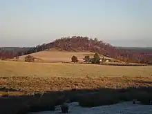
 Dunearn from the south west in winter | |
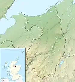
 Dunearn Shown within Nairn | |
| Coordinates | 57.4505°N 3.7836°W |
|---|---|
| Type | Hill fort |
| Length | 245 metres (804 ft) |
| Width | 45 metres (148 ft) |
| Height | 266 metres (873 ft) AOD |
| History | |
| Material | Stone, earth |
| Periods | Iron Age, Pictish |
The site commands uninterrupted views in all directions of the valley of the Findhorn including towards the pass of Streens in the west, which leads to upper Strath Dearn.[1][3]
Etymology
The modern name, which is shared by a nearby farm[2] is from the Scots Gaelic language, Dùn Éireann meaning "Hill(fort) on the Findhorn".[4] Although Gaelic in origin the derivation of the name of the River Findhorn itself is not absolutely clear. Watson (1926) states that it is derived from Fionn Èire, meaning "white Ireland" which "doubtless refers to the white sands of the estuary". The dative Èireann gave rise to the use of the anglified 'earn' or 'erne' in other local names such as Invererne, Cullerne and Earnhill.[5]
Structure
The slopes up to the fort are steep from all directions save the west. The summit is S-shaped and was surrounded by two parallel walls[1] which closely followed the contour that delineates the summit plateau.[6] The visual evidence of the inner rampart is simply scattered stones and boulders along with some evidence of vitrification,[7] suggesting that the fort may have been burned at some point in its history. The outer wall lies about 20 feet (6.1 m) beyond the inner and is a "mere crest-line, dotted rather sparsely with stones and boulders".[1] The proximity of the two walls to one another suggests it was designed as a single structure with stabilising timbers in the centre. The entrance lies to the south west[1] and the enclosed area is roughly .75 hectares (1.9 acres) in extent.[8]

Local comparisons
Dunearn is one of a group of larger, more open, structures such as Craig Phadrig, which is thought to have been constructed in the 4th Century CE[9][lower-alpha 1] and Ord Hill of Kessock, both to the west near modern-day Inverness. There are various smaller structures in the area, such as Doune of Relugas,[10][1] and Dun Earn[11][lower-alpha 2] lower down the Findhorn valley and Dun Evan and Castle Finlay in the Nairn valley.[1] The existence of another large hill fort at Cluny Hill[12] in Forres, which extends to 3.6 hectares (8.9 acres) was confirmed in 2017.[13]
Modern uses
It is thought that the relatively level summit of the hill was farmed for many years until 1906, including ploughing and it is likely that the stone remains of the fortification are "slight" as a result.[1]
An artillery base was established in the fort during the Second World War.[1]
References
Notes
- Craig Phadrig, which is much smaller than Dunearn,[1] is popularly believed to have been the site of the Pictish king Bridei's conversion to Christianity by Columba in 565 CE, although there is no real evidence for this.[9]
- The small fort of Dun Earn is located, rather confusingly, above the Dunearn Burn near its confluence with the River Findhorn about 2 kilometres (1.2 mi) south of Conicavel and 12 kilometres (7.5 mi) downstream from Dunearn.
Citations
- "Dunearn". Canmore. Retrieved 27 May 2018.
- Ordnance Survey. OS Maps Online (Map). 1:25,000. Leisure. Retrieved 28 May 2018.
- “Dunearn“ Ancient Monuments, quoting Historic Scotland. Retrieved 28 May 2018.
- Mac an Tàilleir (2003) p. 43
- Watson (1926) pp. 229-230
- RCAHMS Emergency Survey (1943) p. 185
- Canmore, quoting Feachem.
- "Plane table survey: Dunearn Fort." Canmore. Retrieved 28 May 2018.
- "Craig Phadrig". Canmore. Royal Commission on the Ancient and Historical Monuments of Scotland. Retrieved 28 May 2018.
- "Doune Of Relugas". Canmore. Royal Commission on the Ancient and Historical Monuments of Scotland. Retrieved 17 October 2015.
- "Dun Earn". Canmore. Retrieved 28 May 2018.
- "Cluny Hill". Canmore. Royal Commission on the Ancient and Historical Monuments of Scotland. Retrieved 6 October 2015.
- Isaksen (2017) p. 37
Bibliography
- RCAHMS Emergency Survey.(1943) Manuscripts (vol.2)
- Feachem, R. (1963b) A guide to prehistoric Scotland. 1st. London. Page(s): 140 RCAHMS Shelf Number: E.2.FEA
- Isaksen, Leif (2017) The Hilltop Enclosure on Cluny Hill, Forres description, destruction, disappearance". Lancaster University. Retrieved 28 May 2018.
- Mac an Tàilleir, Iain (2003) Ainmean-àite/Placenames. (pdf) Pàrlamaid na h-Alba. Retrieved 26 August 2012.
- Watson, W. J. (1994) The Celtic Place-Names of Scotland. Edinburgh. Birlinn. ISBN 1-84158-323-5. First published 1926.