Doizieux
Doizieux is a commune in the Loire department in central France.
Doizieux | |
|---|---|
 Crêt de l'Oeillon | |
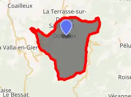
Location of Doizieux 
| |
 Doizieux  Doizieux | |
| Coordinates: 45°25′41″N 4°35′12″E | |
| Country | France |
| Region | Auvergne-Rhône-Alpes |
| Department | Loire |
| Arrondissement | Saint-Étienne |
| Canton | Le Pilat |
| Intercommunality | Saint-Étienne Métropole |
| Government | |
| • Mayor (2014–2020) | Jean-Philippe Porcherot |
| Area 1 | 28.07 km2 (10.84 sq mi) |
| Population (2017-01-01)[1] | 831 |
| • Density | 30/km2 (77/sq mi) |
| Time zone | UTC+01:00 (CET) |
| • Summer (DST) | UTC+02:00 (CEST) |
| INSEE/Postal code | 42085 /42740 |
| Elevation | 440–1,396 m (1,444–4,580 ft) (avg. 640 m or 2,100 ft) |
| 1 French Land Register data, which excludes lakes, ponds, glaciers > 1 km2 (0.386 sq mi or 247 acres) and river estuaries. | |
Geography
The village is situated 50 kilometres (31 mi) southwest of Lyon. It is in the heart of the Parc naturel régional du Pilat.
The Dorlay river, a tributary of the Gier that rises in Mont Pilat, flows through the commune.[2]
Administration
| Periode | Mayor |
|---|---|
| March 2001 | Dominique Crozet |
Population
| Year | Pop. | ±% |
|---|---|---|
| 1962 | 436 | — |
| 1968 | 520 | +19.3% |
| 1975 | 478 | −8.1% |
| 1982 | 521 | +9.0% |
| 1990 | 594 | +14.0% |
| 1999 | 645 | +8.6% |
| 2005 | 791 | +22.6% |
| 2015 | 832 | +5.2% |
See also
References
- "Populations légales 2017". INSEE. Retrieved 6 January 2020.
- CESAME (March 2010). "Prélèvements et gestion quantitative de la ressource sur le bassin versant du Gier Phase 1" (PDF). Saint-Etienne Metropole. p. 6. Retrieved 2012-08-20.
External links
- Doizieux official website (FR)
- Doizieux on Institut géographique national website (FR)
- Doizieux on Insee website
- Location of Doizieux
| Wikimedia Commons has media related to Doizieux. |
This article is issued from Wikipedia. The text is licensed under Creative Commons - Attribution - Sharealike. Additional terms may apply for the media files.