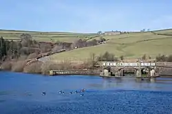
Digley Reservoir
Digley Reservoir is a lake located downstream of Bilberry Reservoir, 2 miles (3.2 km) south west of Holmfirth, in West Yorkshire, England.[2] The reservoir was planned during the 1930s, with much land being bought for its construction, but it was not completed until 1954.
| Digley Reservoir | |
|---|---|
 Digley Reservoir in Holmfirth | |
 Digley Reservoir | |
| Location | West Yorkshire, England |
| Coordinates | 53°33′35″N 1°50′16″W |
| Type | Reservoir |
| Primary inflows | Marsden Clough |
| Catchment area | 2,350 acres (953 ha) |
| Basin countries | United Kingdom |
| Surface area | 42 acres (17 ha) |
| Average depth | 61 feet (18.6 m) |
| Water volume | 660 million imperial gallons (3.0 Gl) |
| Shore length1 | 0.81 miles (1.3 km) |
| Surface elevation | 794 feet (242 m) |
| References | [1] |
| 1 Shore length is not a well-defined measure. | |
History
A bill was presented before Parliament in October 1936 to enable the Huddersfield Corporation to build a reservoir at Digley, impounding Digley Brook. This was passed in July 1937 and required the purchase of several buildings, including two mills and a pub (the Isle of Skye Inn),[3] though one of the mills was derelict.[4] The reservoir did not open until 1954.[5]
Recreation
The area is associated with the TV sitcom ‘Last Of The Summer Wine’, which was filmed in Holmfirth and the surrounding areas.[6] The reservoir has a picnic area, two free car parks and there are also some benches around the lake that provide a quiet place of reflection.[7] There are two main walking routes, the long walking route is 5 miles (8 km) and goes as far as Blackpool Bridge in Holmfirth. The shorter route is an easy circular Peak District walk around the reservoirs, which starts at the car park at the North Eastern end of the reservoir, off Gibriding Lane. It leads around to the North End of the reservoir on Kirklees Way, passing by Bilberry reservoir through to Digley Wood on the southern side of the water, before returning to the car park using Fieldhead Lane.[8] The reservoir is also one of the waypoints on the Yorkshire Water Way.[9]
The reservoir is a source of water for Yorkshire and Yorkshire Water provide the free car parking plus walking route maps to follow. Their Digley, Bilberry and Beyond Walk is 5.5 miles (8.9 km) long[10] and the Digley Walk is 1.5 miles (2.4 km).[11] The Peak District Boundary Walk runs along the west side of the reservoir.[12]
References
- "Digley Reservoir Water Body ID 31685". eip.ceh.ac.uk. Retrieved 6 August 2020.
- "Digley Reservoir Walking Route". www.gps-routes.co.uk. Retrieved 6 August 2020.
- "On this day". NewsBank. 30 October 2009. Retrieved 6 August 2020.
- Woodhead, T W (1939). History of the Huddersfield water supplies. Huddersfield: Tolson Memorial Museum. pp. 126–136.
- Tietavainen, Marika T (September 2013). "Scour valve replacement at Digley reservoir". Dams and Reservoirs. 23 (3–4): 143–151. doi:10.1680/dare.14.00007.
- "Last of the Summer Wine country, Holmfirth, West Yorkshire". The Guardian. 7 June 2009. Retrieved 6 August 2020.
- "Digley Reservoir | The Walking Dad". thewalkingdad.life. 25 June 2017. Retrieved 6 August 2020.
- Moat, Helen (2016). Bradt Slow Travel the Peak District : Local, Characterful Guides to Britain's Special Places (1 ed.). Chalfont St Peter: Bradt. p. 24. ISBN 978-1-78477-007-5.
- "Yorkshire Water Way N Yorkshire, S Yorkshire, W Yorkshire". www.ldwa.org.uk. Retrieved 6 August 2020.
- "Digley long walk | Yorkshire Water". www.yorkshirewater.com. Retrieved 6 August 2020.
- "Digley short walk | Yorkshire Water". www.yorkshirewater.com. Retrieved 6 August 2020.
- McCloy, Andrew (2017). Peak District Boundary Walk: 190 Miles Around the Edge of the National Park. Friends of the Peak District. ISBN 978-1909461536.
