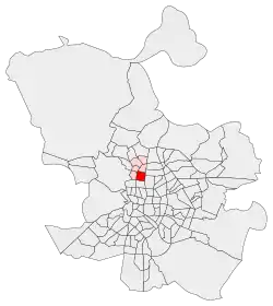
Cuatro Caminos (Madrid)
Cuatro Caminos is a neighborhood (barrio) of Madrid belonging to the district of Tetuán.
Cuatro Caminos | |
|---|---|
_Estadio_Santiago_Bernabeu_-_panoramio.jpg.webp) | |
 | |
| Country | Spain |
| Regiony | Community of Madrid |
| Municipality | Madrid |
| District | Tetuán |
| Area | |
| • Total | 1.193509 km2 (0.460816 sq mi) |
| Population (2020) | |
| • Total | 35,395 |
| • Density | 30,000/km2 (77,000/sq mi) |
It has an area of 1.193509 km2 (0.460816 sq mi).[1] As of 1 February 2020, it has a population of 35,395.[2] It was created as slum of the north of the city, on the east side of the Road of France, currently the calle de Bravo Murillo.[3]
The ward's boundaries are marked by the Calle de Raimundo Fernández Villaverde to the south, the Calle de San Germán (formerly General Yagüe) to the north (separating it from Castillejos); the Glorieta de Cuatro Caminos in the southeast corner, the Calle de Bravo Murillo to the west and the Paseo de la Castellana to the East.[4]
Many of the streets located in the neighborhood are named after Spanish provinces,[5] including Guipúzcoa, Cuenca, Oviedo, Palencia, Jaén, Teruel, Ávila, Salamanca, and La Coruña.[5]
One of the financial districts of Madrid, AZCA, spreads across the southeast of the neighborhood.[6]
References
- Citations
- "Callejero vigente. Barrios". Ayuntamiento de Madrid.
- "Población por distrito y barrio". Ayuntamiento de Madrid. Retrieved 11 March 2020.
- Cruz Salanova 2019, p. 1085.
- Checa Sánchez 1982, p. 167.
- Ezquerra Abadía 1984, p. 57.
- Checa Sánchez 1982, p. 176.
- Bibliography
- Checa Sánchez, Adelaida (1982). "Evolución del plano de los barrios de "Cuatro Caminos" y "Castillejos"". Anales de Geografía de la Universidad Complutense. Madrid: Servicio de Publicaciones de la Universidad Complutense de Madrid (2): 167–182. ISSN 0211-9803.CS1 maint: ref=harv (link)
- Cruz Salanova, Luis de la (2019). "Política de merendero y descampado: la construcción social del extrarradio madrileño" (PDF). In Fernández Sirvent, Rafael; Gutiérrez Lloret, Rosa Ana (eds.). Del siglo XIX al XXI. Tendencias y debates: XIV Congreso de la Asociación de Historia Contemporánea, Universidad de Alicante 20-22 de septiembre de 2018. Alicante: Biblioteca Virtual Miguel de Cervantes. pp. 1085–1098. ISBN 978-84-17422-62-2.CS1 maint: ref=harv (link)
- Ezquerra Abadía, Ramón (1984). "Las provincias y regiones españolas en el callejero madrileño" (PDF). Villa de Madrid. Madrid: Ayuntamiento de Madrid (81): 55–58. ISSN 0042-6164.CS1 maint: ref=harv (link)