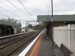
Croydon railway station, Melbourne
Croydon railway station is located on the Lilydale line in Victoria, Australia. It serves the eastern Melbourne suburb of Croydon, and has 420 car parking spaces and 8 bike lockers. The station opened as South Warrandyte Station on 1 December 1882, being renamed Croydon on 1 August 1884.[2]
Croydon | |||||||||||
|---|---|---|---|---|---|---|---|---|---|---|---|
 Westbound view from Platform 2 in March 2009 | |||||||||||
| Location | Wicklow Avenue, Croydon | ||||||||||
| Coordinates | 37°47′43″S 145°16′50″E | ||||||||||
| Owned by | VicTrack | ||||||||||
| Operated by | Metro | ||||||||||
| Line(s) | Lilydale | ||||||||||
| Distance | 31.03 kilometres from Southern Cross | ||||||||||
| Platforms | 2 side | ||||||||||
| Tracks | 2 | ||||||||||
| Connections | Bus | ||||||||||
| Construction | |||||||||||
| Structure type | Ground | ||||||||||
| Parking | 420 | ||||||||||
| Bicycle facilities | 8 | ||||||||||
| Other information | |||||||||||
| Status | Premium station | ||||||||||
| Station code | CDN | ||||||||||
| Fare zone | Myki zone 2 | ||||||||||
| Website | Public Transport Victoria | ||||||||||
| History | |||||||||||
| Opened | 1 December 1882 | ||||||||||
| Electrified | Yes | ||||||||||
| Passengers | |||||||||||
| 2008-2009 | 0.886 million[1] | ||||||||||
| 2009-2010 | 0.881 million[1] | ||||||||||
| 2010-2011 | 0.932 million[1] | ||||||||||
| 2011-2012 | 0.885 million[1] | ||||||||||
| 2012-2013 | Not measured[1] | ||||||||||
| 2013-2014 | 0.822 million[1] | ||||||||||
| Services | |||||||||||
| |||||||||||
Platform 1 opened on 30 June 1984 as part of the line duplication between Croydon and Ringwood.[3] It was upgraded to a Premium station on 31 July 1996.[4]
Platforms & services
Croydon has two side platforms. It is serviced by Metro Trains' Lilydale line services.[5]
Platforms 1:
- Lilydale line: all stations and limited stops services to Flinders Street and Ringwood
Platforms 2:
- Lilydale line: all stations services to Lilydale
Transport links
Transdev Melbourne operate one route from Croydon station:
- 380: to Ringwood station (loop)[6]
Ventura Bus Lines operate nine routes via Croydon station:
- 664: Chirnside Park Shopping Centre - Westfield Knox[7]
- 670: Ringwood station - Swinburne University[8]
- 671: to Chirnside Park Shopping Centre[9]
- 672: to Chirnside Park Shopping Centre[10]
- 688: to Upper Ferntree Gully station[11]
- 689: to Montrose[12]
- 690: to Boronia station[13]
- 737: to Monash University[14]
- Telebus 4: to Mooroolbark station[15]
- Sky bus to and from Melbourne Airport: Eastern express
References
- "Train Station Patronage FY2008-2014". Public Transport Victoria. 14 May 2015. Archived from the original (XLS) on 30 March 2016. Retrieved 1 November 2016. (access from Archived 3 November 2016 at the Wayback Machine)
- "Croydon". vicsig.net. Retrieved 15 July 2019.
- Waugh, Andrew (3 November 1998). "Box Hill – Lilydale to Belgrave" (PDF). SRS Showday Tour Notes. VR History.
- "Upgrading Eltham to a Premium Station". Newsrail. Australian Railway Heritage Society. October 1997. p. 310.
- "Lilydale Line". Public Transport Victoria.
- "380 Ringwood - Croydon Loop". Public Transport Victoria.
- "664 Chirnside Park - Knox City via Croydon & Bayswater". Public Transport Victoria.
- "670 Ringwood - Lilydale via Croydon & Chirnside Park". Public Transport Victoria.
- "671 Croydon - Chirnside Park via Warrien Road & Patrick Street". Public Transport Victoria.
- "672 Croydon - Chirnside Park via Wonga Park & Croydon Hills". Public Transport Victoria.
- "688 Croydon - Upper Ferntree Gully via Olinda and Tremont". Public Transport Victoria.
- "689 Croydon - Montrose via Hawthory Road & Durham Road". Public Transport Victoria.
- "690 Croydon - Boronia via Kilsyth & Canterbury Gardens & Kilsyth South". Public Transport Victoria.
- "737 Croydon - Monash University via Boronia & Knox City Shopping Centre & Glen Waverley". Public Transport Victoria.
- "Ferntree Gully - Stud Park SC (Telebus Area 7)". Public Transport Victoria.
External links
 Media related to Croydon railway station, Melbourne at Wikimedia Commons
- Melway map at street-directory.com.au
This article is issued from Wikipedia. The text is licensed under Creative Commons - Attribution - Sharealike. Additional terms may apply for the media files.