Consul, Saskatchewan
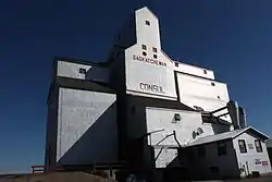
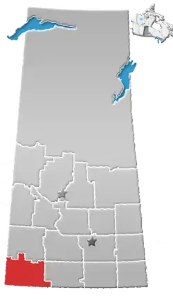
Consul (2016 population: 73) is a village in the Canadian province of Saskatchewan within the Rural Municipality of Reno No. 51 and Census Division No. 4. The historic Red Coat Trail and Highway 21 pass through the village. The village features one of the last existing grain elevators in the region. It is 211 km southwest of the City of Swift Current.
Consul | |
|---|---|
| Village of Consul | |
 The Former Saskatchewan Wheat Pool elevators in Consul | |
 Consul  Consul | |
| Coordinates: 49.2954°N 109.5198°W | |
| Country | Canada |
| Province | Saskatchewan |
| Region | Southwest |
| Census division | 4 |
| Rural Municipality | Reno No. 51 |
| Government | |
| • Type | Municipal |
| • Governing body | Consul Village Council |
| • Mayor | Linda Brown |
| • Administrator | Yvonne Leismeister |
| • MP | Jeremy Patzer |
| • MLA | Doug Steele |
| Area | |
| • Land | 0.65 km2 (0.25 sq mi) |
| Population (2016) | |
| • Total | 84 |
| • Density | 130.1/km2 (337/sq mi) |
| Time zone | UTC-6 (CST) |
| Postal code | S0N 0P0 |
| Area code(s) | 306 |
| Highways | |
| Railways | Great Western Railway |
History
Consul incorporated as a village on June 12, 1917.[1]
Demographics
In the 2016 Census of Population conducted by Statistics Canada, the Village of Consul recorded a population of 73 living in 39 of its 40 total private dwellings, a -15.1% change from its 2011 population of 84. With a land area of 0.65 km2 (0.25 sq mi), it had a population density of 112.3/km2 (290.9/sq mi) in 2016.[4]
In the 2011 Census of Population, the Village of Consul recorded a population of 84, a -9.7% change from its 2006 population of 93. With a land area of 0.65 km2 (0.25 sq mi), it had a population density of 129.2/km2 (334.7/sq mi) in 2011.[5]
Education

Consul School is a Kindergarten to Grade 12 facility serving approximately 70 students in the extreme southwest corner of Saskatchewan. Consul School is a part of the Chinook School Division which includes most of the southwest of Saskatchewan.
References
- "Urban Municipality Incorporations". Saskatchewan Ministry of Government Relations. Archived from the original on October 15, 2014. Retrieved June 1, 2020.
- "Saskatchewan Census Population" (PDF). Saskatchewan Bureau of Statistics. Archived from the original (PDF) on September 24, 2015. Retrieved May 31, 2020.
- "Saskatchewan Census Population". Saskatchewan Bureau of Statistics. Retrieved May 31, 2020.
- "Population and dwelling counts, for Canada, provinces and territories, and census subdivisions (municipalities), 2016 and 2011 censuses – 100% data (Saskatchewan)". Statistics Canada. February 8, 2017. Retrieved May 30, 2020.
- "Population and dwelling counts, for Canada, provinces and territories, and census subdivisions (municipalities), 2011 and 2006 censuses (Saskatchewan)". Statistics Canada. June 3, 2019. Retrieved May 30, 2020.
