Clayhole, Kentucky
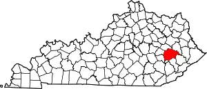
Clayhole is an unincorporated community in Breathitt County, Kentucky. Clayhole is located on Kentucky Route 476 7.6 miles (12.2 km) southeast of Jackson.[2] Clayhole has a post office with ZIP code 41317.[3][4]
Clayhole, Kentucky | |
|---|---|
 Clayhole, Kentucky | |
| Coordinates: 37°28′02″N 83°17′51″W | |
| Country | United States |
| State | Kentucky |
| County | Breathitt |
| Elevation | 807 ft (246 m) |
| Time zone | UTC-5 (Eastern (EST)) |
| • Summer (DST) | UTC-4 (EDT) |
| ZIP code | 41317 |
| Area code(s) | 606 |
| GNIS feature ID | 507710[1] |
The most prominent church is Clayhole Brethren Church. There is another church located on Riley Branch Road in Clayhole as well, which has a small cemetery located on its grounds in which less than ten (10) people are currently buried. There are two much larger cemeteries located in Clayhole, Kentucky: the T-Point Cemetery (The Haddix Family Cemetery is also located beside the church building on the T-Point); and the McIntosh Cemetery. These cemeteries are located within approximately two and one/half to three miles of each other on the main paved road running through Clayhole.
References
- "Clayhole". Geographic Names Information System. United States Geological Survey.
- State Primary Road System: Breathitt County (PDF) (Map). Kentucky Transportation Cabinet. 2012. Retrieved June 9, 2013.
- United States Postal Service (2012). "USPS - Look Up a ZIP Code". Retrieved 2012-02-15.
- "Postmaster Finder - Post Offices by ZIP Code". United States Postal Service. Retrieved June 9, 2013.
