Carchi Province
Carchi (Spanish pronunciation: [ˈkaɾtʃi]) is a province in Ecuador. The capital is Tulcán. The Carchi River rises on the slopes of Chiles volcano and forms the boundary between Colombia and Ecuador near Tulcan. Rumichaca Bridge is the most important land route between Colombia and Ecuador.
Carchi | |
|---|---|
Province | |
| Province of Carchi | |
 Flag | |
| Nickname(s): Heir of the Sun, and Earth | |
.svg.png.webp) Carchi Province in Ecuador | |
 Cantons of Carchi Province | |
| Country | |
| Legal establishment | November 19, 1880 |
| Capital | Tulcán |
| Area | |
| • Total | 3,780.45 km2 (1,459.64 sq mi) |
| Population (2010 census) | |
| • Total | 164,524 |
| • Density | 44/km2 (110/sq mi) |
| Time zone | UTC-5 (ECT) |
| Vehicle registration | C |
| HDI (2017) | 0.727[1] high · 12th |
| Website | www |
Economy
The provincial economy is based on industrial, and agriculture productions. Carchi produces food, drinks, tobacco, and dairy products. The agriculture sector produces potatoes, maize, etc.[2]
Cantons
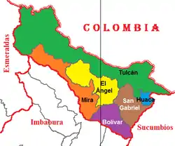
The province is divided into 6 cantons. The following table lists each with its population at the 2010 census, its area in square kilometres (km²), and the name of the canton seat or capital.[3]
| Canton | Pop. (2019) | Area (km²) | Seat/Capital |
|---|---|---|---|
| Bolívar | 15,500 | 353 | Bolívar |
| Espejo | 13,860 | 554 | El Ángel |
| Mira | 12,070 | 588 | Mira |
| Montúfar | 34,030 | 383 | San Gabriel |
| San Pedro de Huaca | 8,840 | 71 | Huaca |
| Tulcán | 101,230 | 1,801 | Tulcán |
Demographics
Ethnic groups as of the Ecuadorian census of 2010:[4]
- Mestizo 86.9%
- Afro-Ecuadorian 6.4%
- Indigenous 3.4%
- White 2.9%
- Montubio 0.3%
- Other 0.1%
Tourist destinations

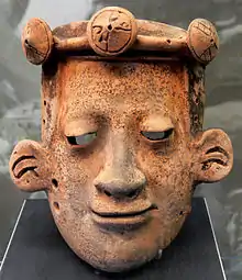
Ancient Carchi art
- Tulcán Cemetery - topiary garden cemetery;
- El Ángel ecological reserve, El Ángel - extensive páramo ecosystem with diverse biotopes, including the visually striking páramos de frailejones - moorland with a forest of ancient, up to 10 m tall Espeletia pycnophylla plants;
- Arrayanes Forest, San Gabriel - 16 ha large forest with rare trees whose bark is in cinnamon color;
- Lagunas Verdes on the way from Tufiño to Maldonado. Three lakes of volcanic origin with blue - green water, rich with sulphur;
- Gruta de la Paz, San Gabriel - show cave with a shrine of Virgin Mary;
- Laguna del Salado, San Gabriel - a serene lagoon with translucent water;
- Tufiño Hot Springs, Tulcán;
- "El Voladero" lagoons, El Angel;
- De Paluz Falls, San Gabriel;
- Guanderas Scientific Station, Huaca - a biological research station for montane ecosystems.
See also
References
- Villalba, Juan. "Human Development Index in Ecuador". Scribd (in Spanish). Retrieved 2019-02-05.
- "ExploRed - ECUADOR online". explored.com.ec. Archived from the original on 2012-05-11. Retrieved 2009-05-07.
- Cantons of Ecuador. Statoids.com. Retrieved 4 November 2009.
- Instituto Nacional de Estadística y Censos. "Resultados". Instituto Nacional de Estadística y Censos.
External links
| Wikimedia Commons has media related to Carchi Province. |
- (in Spanish) Gobierno Provincial del Carchi, official website
- (in Spanish) ¡Con el Carchi no se juega!
- (in English) "DEJA VU" OF HISTORY: YOU DON'T MESS WITH CARCHI
This article is issued from Wikipedia. The text is licensed under Creative Commons - Attribution - Sharealike. Additional terms may apply for the media files.