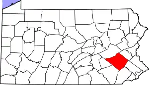
Caernarvon Township, Berks County, Pennsylvania
Caernarvon Township is a township in Berks County, Pennsylvania, United States. The population was 4,006 at the 2010 census. It is often referred to as Morgantown, the township's largest village.
Caernarvon Township, Berks County, Pennsylvania | |
|---|---|
 Municipal offices and police department in Morgantown | |
 Caernarvon Township Location of Caernarvon Township in Pennsylvania  Caernarvon Township Caernarvon Township (the United States) | |
| Coordinates: 40°10′02″N 75°52′42″W | |
| Country | United States |
| State | Pennsylvania |
| County | Berks |
| Founded | 1752 |
| Area | |
| • Total | 8.91 sq mi (23.08 km2) |
| • Land | 8.87 sq mi (22.98 km2) |
| • Water | 0.04 sq mi (0.10 km2) |
| Elevation | 620 ft (190 m) |
| Population (2010) | |
| • Total | 4,006 |
| • Estimate (2016)[2] | 4,070 |
| • Density | 458.75/sq mi (177.12/km2) |
| Time zone | UTC-5 (EST) |
| • Summer (DST) | UTC-4 (EDT) |
| Area code(s) | 610 |
| FIPS code | 42-011-10696 |
| Website | www |
History
Caernarvon was so named by Welsh settlers[3] after the town of Caernarfon in North Wales.
In 1718 William Davies and a band of Welsh settlers obtained land warrants stretching from the headwaters of the Conestoga River and reaching several miles downstream. When Lancaster County was established in 1729, this region was given the name Caernarvon Township in honor of its inhabitants. When a portion of Lancaster County was transferred to the newly organized Berks County in 1752, the new boundary ran through existing Caernarvon Township as well as neighboring Brecknock Township.[4]
Morgantown Historic District was listed on the National Register of Historic Places in 1995.[5]
On May 28, 2019, an EF2 tornado hit Caernarvon Township, causing substantial damage to the area. Several residents and businesses were displaced as a result of the storm.[6][7] It was the most powerful tornado to hit Berks County since the 1998 Lyons tornado.
Geography
According to the United States Census Bureau, the township has a total area of 8.9 square miles (23 km2), of which, 8.9 square miles (23 km2) of it is land and 0.11% is water. The township is partially located in the Hopewell Big Woods.
Adjacent townships
Adjacent boroughs
- New Morgan (N)
- Elverson (SE)
Recreation
A portion of Pennsylvania State Game Lands Number 43 and Number 52 are located in the township.[8][9][10]
Demographics
| Historical population | |||
|---|---|---|---|
| Census | Pop. | %± | |
| 1980 | 1,710 | — | |
| 1990 | 1,933 | 13.0% | |
| 2000 | 2,312 | 19.6% | |
| 2010 | 4,006 | 73.3% | |
| 2016 (est.) | 4,070 | [2] | 1.6% |
| Source: US Census Bureau | |||
As of the census[11] of 2000, there were 2,312 people, 888 households, and 658 families residing in the township. The population density was 260.3 people per square mile (100.5/km2). There were 925 housing units at an average density of 104.1/sq mi (40.2/km2). The racial makeup of the township was 97.79% White, 0.30% African American, 0.78% Asian, 0.22% from other races, and 0.91% from two or more races. Hispanic or Latino of any race were 0.87% of the population.
There were 888 households, out of which 32.4% had children under the age of 18 living with them, 64.1% were married couples living together, 6.6% had a female householder with no husband present, and 25.9% were non-families. 21.5% of all households were made up of individuals, and 8.4% had someone living alone who was 65 years of age or older. The average household size was 2.60 and the average family size was 3.05.
In the township the population was spread out, with 26.1% under the age of 18, 6.5% from 18 to 24, 29.2% from 25 to 44, 24.1% from 45 to 64, and 14.2% who were 65 years of age or older. The median age was 38 years. For every 100 females, there were 98.1 males. For every 100 females age 18 and over, there were 95.1 males.
The median income for a household in the township was $49,041, and the median income for a family was $57,574. Males had a median income of $37,639 versus $27,273 for females. The per capita income for the township was $21,250. About 2.9% of families and 6.1% of the population were below the poverty line, including 12.1% of those under age 18 and none of those age 65 or over.
References
- "2016 U.S. Gazetteer Files". United States Census Bureau. Retrieved Aug 13, 2017.
- "Population and Housing Unit Estimates". Retrieved June 9, 2017.
- "Local school children to hear history of Berks and deeds of noted citizens". Reading Eagle. Mar 6, 1927. p. 5. Retrieved 2 December 2015.
- Historical Background of Caernarvon Township, Berks County
- "National Register Information System". National Register of Historic Places. National Park Service. July 9, 2010.
- https://www.readingeagle.com/news/article/tornado-hits-berks-county-caernarvon-township-neighborhood-struck-by-terror-from-above
- https://www.wfmz.com/news/berks/watch-aerial-video-of-tornado-damage-in-caernarvon/1081874986
- https://viewer.nationalmap.gov/advanced-viewer/ The National Map, retrieved 24 October 2018
- Pennsylvania State Game Lands Number 43, retrieved 25 October 2018
- Pennsylvania State Game Lands Number 52, retrieved 25 October 2018
- "U.S. Census website". United States Census Bureau. Retrieved 2008-01-31.
