Bredgar
Bredgar is a village and civil parish in the borough of Swale in Kent, England.
| Bredgar | |
|---|---|
 | |
 Bredgar Location within Kent | |
| Population | 659 (2011 Census)[1] |
| District | |
| Shire county | |
| Region | |
| Country | England |
| Sovereign state | United Kingdom |
| Post town | Sittingbourne |
| Postcode district | ME9 |
| Police | Kent |
| Fire | Kent |
| Ambulance | South East Coast |
| UK Parliament | |
Location
The village lies to the southwest of Sittingbourne on the road between Tunstall and Hollingbourne (previously the B2163).[2] The M2 motorway crosses the parish. Junction 5 is west of the village.[3]
History
A hoard of 34 Roman coins including 15 gold aurei was discovered in the parish in 1957. It is thought to be related to the Claudian invasion, possibly buried by a soldier before the Battle of the Medway.[4][5]
In the reign of King Henry III (12th century), Robert de Bredgar, resided here and his name appears in an ancient roll of the benefactors to the monastery of Davington (in Faversham). The village was then named after this family.[6]
The village was originally called Bradgare. The parish had around 1300 acres of land, of which one hundred acres are covered by wood. With Tunstall and Bobbing, it was controlled by the Manor of Milton.[6]
Features
The parish includes several Grade II listed buildings. These include Swanton Court, a 16th-century house,[7] and the 15th century Mann's Place.[8] Bredgar House is in the centre of the village, and was constructed in the 18th century.[9] A war memorial was constructed in the village centre by the pond in 1920, to commemorate soldiers fallen in World War I, and later updated for World War II. It was Grade II listed in 2007.[10]
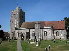
The parish also has its own church, St John The Baptist Church, which is in the diocese of Canterbury, and the deanery of Sittingbourne.[6] It is Grade I listed.[11] King Henry III gave out alms from this church to the leprous women of the hospital of St. James, (alias St. Jacob), near Thanington, near Canterbury.[6] It was refurbished in 2014, including the installation of running water.[12]
The Sun Inn is the village's pub. It has existed since the 16th century and features a large garden.[13]
Bredgar is home to the privately owned Bredgar & Wormshill Light Railway, a steam railway with a collection of various locomotives and rolling stock. The railway is open to the public on Saturdays through the summer.[14]
References
- "Civil Parish population 2011". Neighbourhood Statistics. Office for National Statistics. Retrieved 20 September 2016.
- "Hollingbourne to Sittingbourne Road to be closed for six weeks". Hollingbourne Parish Council. 30 March 2017. Retrieved 3 March 2020.
- "M2 Junction 5 Improvements" (PDF). Highways England. Retrieved 3 March 2020.
- "Hoards and hoarding". Current Archaeology. 1 October 2010. Retrieved 29 April 2016.
- "Coin – Unique ID: ESS-F8A767". Portable Antiquities Scheme. 24 February 2011. Retrieved 29 April 2016.
- Hasted, Edward (1798). "Parishes". The History and Topographical Survey of the County of Kent. Institute of Historical Research. 6: 98–106. Retrieved 12 February 2014.
- Historic England. "Details from listed building database (1116488)". National Heritage List for England. Retrieved 3 March 2020.
- Historic England. "Details from listed building database (1069360)". National Heritage List for England. Retrieved 3 March 2020.
- Historic England. "Details from listed building database (1069365)". National Heritage List for England. Retrieved 3 March 2020.
- Historic England. "Details from listed building database (1392296)". National Heritage List for England. Retrieved 3 March 2020.
- Historic England. "Details from listed building database (1343876)". National Heritage List for England. Retrieved 3 March 2020.
- "Revamp at St John the Baptist Church in Bexon Lane, Bredgar". Kent Online. 31 January 2014. Retrieved 3 March 2020.
- "13 of Kent's best pub gardens". Kent Online. 24 August 2019. Retrieved 3 March 2020.
- "Bredgar and Wormshill Light Railway plays host on Second World War visitors' day". Kent Online. 3 June 2013. Retrieved 3 March 2020.