Bogong, Victoria
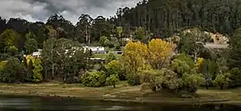
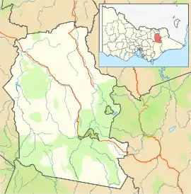
Bogong is a locality in north east Victoria, Australia. The locality is in the Alpine Shire local government area, 371 kilometres (231 mi) north east of the state capital, Melbourne.
| Bogong Victoria | |
|---|---|
 Bogong, 2014 | |
 Bogong | |
| Coordinates | 36°48′11″S 147°13′26″E |
| Population | 5 (2016 census)[1] |
| Postcode(s) | 3699 |
| Location |
|
| LGA(s) | Alpine Shire |
| State electorate(s) | Benambra |
| Federal Division(s) | Indi |
At the 2016 census, Bogong had a population of 5.[1]
Climate
| Climate data for Bogong, VIC (Bogong [1938-2001]); 718 m AMSL; 36° 48′ 20.16″ S | |||||||||||||
|---|---|---|---|---|---|---|---|---|---|---|---|---|---|
| Month | Jan | Feb | Mar | Apr | May | Jun | Jul | Aug | Sep | Oct | Nov | Dec | Year |
| Record high °C (°F) | 38.3 (100.9) |
38.3 (100.9) |
33.9 (93.0) |
29.4 (84.9) |
22.8 (73.0) |
19.2 (66.6) |
17.1 (62.8) |
20.6 (69.1) |
22.2 (72.0) |
25.6 (78.1) |
31.1 (88.0) |
35.0 (95.0) |
38.3 (100.9) |
| Average high °C (°F) | 26.0 (78.8) |
25.7 (78.3) |
23.5 (74.3) |
17.8 (64.0) |
13.2 (55.8) |
10.3 (50.5) |
8.9 (48.0) |
10.3 (50.5) |
13.7 (56.7) |
16.8 (62.2) |
19.8 (67.6) |
23.1 (73.6) |
17.4 (63.4) |
| Average low °C (°F) | 10.8 (51.4) |
11.1 (52.0) |
9.5 (49.1) |
6.4 (43.5) |
3.8 (38.8) |
1.7 (35.1) |
0.9 (33.6) |
1.5 (34.7) |
3.0 (37.4) |
5.1 (41.2) |
6.9 (44.4) |
9.0 (48.2) |
5.8 (42.4) |
| Record low °C (°F) | 2.2 (36.0) |
2.2 (36.0) |
0.0 (32.0) |
−0.6 (30.9) |
−2.8 (27.0) |
−4.4 (24.1) |
−6.1 (21.0) |
−6.0 (21.2) |
−5.0 (23.0) |
−3.3 (26.1) |
−0.6 (30.9) |
−1.1 (30.0) |
−6.1 (21.0) |
| Average precipitation mm (inches) | 77.8 (3.06) |
71.3 (2.81) |
92.8 (3.65) |
127.5 (5.02) |
179.1 (7.05) |
193.6 (7.62) |
243.4 (9.58) |
242.5 (9.55) |
173.8 (6.84) |
171.4 (6.75) |
124.3 (4.89) |
101.3 (3.99) |
1,798.8 (70.81) |
| Average precipitation days (≥ 0.2 mm) | 7.5 | 6.6 | 7.9 | 9.7 | 13.8 | 14.6 | 16.9 | 17.3 | 14.5 | 14.4 | 11.9 | 9.3 | 144.4 |
| Source: Australian Bureau of Meteorology; Bogong, VIC | |||||||||||||
Bogong yields a maritime climate with warm summers and cool, snowy winters.
References
- Australian Bureau of Statistics (27 June 2017). "Bogong". 2016 Census QuickStats. Retrieved 7 August 2017.

This article is issued from Wikipedia. The text is licensed under Creative Commons - Attribution - Sharealike. Additional terms may apply for the media files.