Bitterroot River
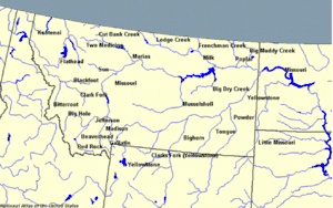
The Bitterroot River is a northward flowing 84-mile (135 km)[2] river running through the Bitterroot Valley, from the confluence of its West and East forks near Conner in southern Ravalli County to its confluence with the Clark Fork River near Missoula in Missoula County, in western Montana. The Clark Fork River is tributary to the Columbia River and ultimately, the Pacific Ocean. The Bitterroot River is a Blue Ribbon trout fishery with a healthy population of native westslope cutthroat trout and bull trout. It is the third most fly fished river in Montana behind the Madison and Big Horn Rivers.[2]
| Bitterroot River St. Mary's River | |
|---|---|
.jpg.webp) Ice fog hanging over Bitterroot River at Lee Metcalf National Wildlife Refuge | |
| Native name | Spet-lum and In-shi-ttogh-tae-tkhu |
| Location | |
| Country | United States |
| State | Montana |
| Region | Missoula and Ravalli County, Montana |
| Physical characteristics | |
| Source | Confluence of |
| • coordinates | 45°56′24″N 114°07′38″W[1] |
| Mouth | Confluence with Clark Fork River |
• location | Missoula, Montana |
• coordinates | 46°51′42″N 114°07′09″W[1] |
• elevation | 3,104 ft (946 m)[1] |
| Length | 75 mi (121 km), South-north |
| Basin size | 2,814 sq mi (7,290 km2) |
| Discharge | |
| • location | Missoula |
| • average | 2,370 cu ft/s (67 m3/s) |
| • minimum | 270 cu ft/s (7.6 m3/s) |
| • maximum | 38,300 cu ft/s (1,080 m3/s) |
| Basin features | |
| River system | Columbia Basin |

History
The Bitterroot River is named for the bitterroot plant Lewisia rediviva, whose fleshy taproot was an important food source for Native Americans.[3] The Salish called the river Spet-lum for "Place of the bitterroot" and In-shi-ttogh-tae-tkhu for "Willow River".[3] French trappers knew the plant as racine amère (bitter root).[4] The early Jesuit priest, Father De Smet, named it St. Mary's River.[4] By the time of Washington Territory surveys by Governor Isaac I. Stevens in 1853, the name had been translated to Bitterroot River.[3]
Watershed
The Bitterroot River watershed drains 2,889 square miles (7,480 km2) in Ravalli and Missoula counties.[2] The Bitterroot Valley averages 7–10 miles wide and is uniquely low gradient for western Montana streams. The river mainstem begins at the confluence of the East Fork Bitterroot River[5] and the West Fork Bitterroot River.[6] From there the mainstem receives numerous tributaries from the Bitterroot Mountains to the west and the Sapphire Mountains to the east.[2] The watershed is a snowmelt dominated system with large interannual variations in streamflow and peak flows from mid-May to mid-June.[7] The variation is compounded by extensive irrigation withdrawals and upstream reservoir storage at Painted Rocks Reservoir on the West Fork Bitterroot River with the most severely dewatered reaches along 12 miles (19 km) of the river located between Woodside Crossing near Corvallis and Bell Crossing near Stevensville.[2]
Major tributaries include Skalkaho Creek, and Lolo Creek. The Skalkaho Creek drainage subwatershed originates in the Sapphire Mountains and drains 132 square miles (340 km2) and flows 28 miles (45 km) west-northwest to it confluence with the Bitterroot River.[8] Lolo Creek is the primary tributary in the northern portion of the Bitterroot watershed.[9] Lolo Creek is often completely dewatered in late summer in its lower 2 miles (3.2 km) due to withdrawals for irrigation and rural water use.[2]
Habitat and wildlife
Although the Bitterroot River passes close by to many residential areas, it is an excellent place for wildlife viewing. Many species of ducks and waterfowl are common along with osprey, bald eagles and heron. Elk (Cervus canadensis), moose (Alces alces), and both white-tailed deer (Odocoileus virginianus) and mule deer (Odocoileus hemionus) frequent the river as a source of water and to graze near its banks. The most notable wildlife viewing locale along the river is the famous Lee Metcalf National Wildlife Refuge, named for U.S. Senator Lee Metcalf, a pioneer of the conservation movement.
A renowned fly fishing stream, the Bitterroot River mainstem and many of its tributaries are important migratory corridors and spawning habitat for native westslope cutthroat trout (Oncorhynchus clarki lewisi) and bull trout (Salvelinus confluentus). Other native fish include mountain whitefish (Prosopium williamsoni), longnose sucker (Catostomus catostomus), slimy sculpin (Cottus cognatus), and longnose dace (Rhinichthys cataractae).[7]
Rainbow trout (Oncorhynchus mykiss) and brown trout (Salmo trutta) are popular gamefish but are not native to the Bitterroot River watershed and pose significant threats to native trout. In Montana, rainbow trout are only native to the upper Kootenai River in the state's extreme northwest corner.[10] Non-native rainbow trout pose one of the greatest threats to cutthroat trout by hybridization, producing "cutbows".[11][12] In addition, non-native brook trout (Salvelinus fontinalis) often displace native cutthroat trout and bull trout in small streams.[7][13]
Recreation
The towns along the Bitterroot River, including Hamilton, Stevensville, Missoula, and Darby are popular destinations for fly fishing, with rainbow trout being fairly prevalent and with smaller populations of brown trout and westslope cutthroat trout. The Bitterroot is a Class I river from the confluence of the East and West forks to its confluence with the Clark Fork River for public access for recreational purposes.[14]
In popular culture
- The song "Bitterroot" by the Indigo Girls is about the Bitterroot River.
- The Bitterroot River and its watershed is mentioned extensively in Norman MacLean's novella "A River Runs Through It"
Gallery
|
See also
- 2000–2001 fires in the Western United States
- Montana Stream Access Law
- List of rivers of Montana
References
- "Bitterroot River". Geographic Names Information System. United States Geological Survey.
- Bitterroot River Strategy (PDF) (Report). Clark Fork Coalition. 2017. Retrieved July 15, 2017.
- Rich Aarstad; Ellie Arguimbau; Ellen Baumler; Charlene Porsild; Brian Shovers (2009). Montana Place Names from Alzada to Zortman. Montana Historical Society. ISBN 978-0-9759196-1-3.
- Genevieve F. Murray (1929). The bitter root (Lewisia rediviva) in science and in history (Thesis). University of Montana. Retrieved July 15, 2017.
- "East Fork Bitterroot River". Geographic Names Information System. United States Geological Survey.
- "West Fork Bitterroot River". Geographic Names Information System. United States Geological Survey.
- Clint M. Sestrich, Thomas E. McMahon, Michael K. Young (2011). "Influence of Fire on Native and Nonnative Salmonid Populations and Habitat in a Western Montana Basin". Transactions of the American Fisheries Society. 140: 136–146. doi:10.1080/00028487.2011.557019 (inactive 2021-01-15). Retrieved July 16, 2017.CS1 maint: uses authors parameter (link) CS1 maint: DOI inactive as of January 2021 (link)
- Bitterroot Watershed Restoration Plan (PDF) (Report). Bitter Root Water Forum. March 20, 2014. Retrieved July 16, 2017.
- Montana Water Trust, Bitter Root Water Forum, Geum Environmental Consulting, Inc., Will McDowell (2009). Bitterroot River Subbasin Plan, in Columbia River Basin Fish and Wildlife Program (PDF) (Report). Portland, Oregon: Northwest Power and Conservation Council. Retrieved July 16, 2017.CS1 maint: uses authors parameter (link)
- "Rainbow Trout - Oncorhynchus mykiss, Montana Field Guide". Montana Natural Heritage Program and Montana Fish, Wildlife and Parks. Retrieved July 16, 2017.
- Robert J. Behnke (1992). Native trout of western North America. American Fisheries Society. ISBN 978-0-913235-79-9.
- Clint C. Muhlfeld, Ryan P. Kovach, Robert Al-Chokhachy, Stephen J. Amish, Jeffrey L. Kershner, Robb F. Leary, Winsor H. Lowe, Gordon Luikart, Phil Matson, David A. Schmetterling, Bradley B. Shepard, Peter A. H. Westley, Diane Whited, Andrew Whiteley, Fred W. Allendorf (2017). "Legacy introductions and climatic variation explain spatiotemporal patterns of invasive hybridization in a native trout". Global Change Biology. 23 (11): 4663–4674. Bibcode:2017GCBio..23.4663M. doi:10.1111/gcb.13681. PMID 28374524. S2CID 10078714.CS1 maint: uses authors parameter (link)
- Susan B. Adams, Christopher A. Frissell, Bruce E. Rieman (2001). "Geography of Invasion in Mountain Streams: Consequences of Headwater Lake Fish Introductions". Ecosystems. 4 (4): 296–307. doi:10.1007/s10021-001-0012-5. JSTOR 3658927. S2CID 2142218.CS1 maint: uses authors parameter (link)
- Stream Access in Montana Archived 2009-03-10 at the Wayback Machine, Montana Department of Fish, Wildlife and Parks
Further reading
- Sullivan, Gordon (2008). Saving Homewaters-The Story of Montana's Streams and Rivers. Woodstock, VT: The Countryman Press. ISBN 9780881506792.
External links
- Explore the Bitterroot
- Robbins, Jim (July 26, 2006). "Tug of War Is On in Montana Over Public Access to Waterway". The New York Times. Retrieved 2012-05-12.
- Lee Metcalf National Wildlife Refuge Website
| Wikimedia Commons has media related to Bitterroot River. |

.jpg.webp)
.jpg.webp)
.jpg.webp)


.jpg.webp)
.jpg.webp)

